Tip: Use the outline on the left to jump between sections quickly.
Geography UPSC Notes Complete
Vanshika72 min read
24
Complete UPSC Geography Notes covering physical geography, world geography, Indian geography and exam-oriented concepts with illustrations for Prelims & Mains.
The most scientific theory which explains origin of universe is Big Bang Theory. It was given by George's Lemaitre, a Belgium physicist in 1927. According to this theory the universe came into being about 13.8 billion years ago after a big explosion that is called Big Bang.
Before Big Bang the present universe was confined into an atom size spec/ ball.
This was stage of singularity. Singularity means the stage when there is no space no time no matter exists.
During this time there was infinite pressure, temperature, and density.
The four fundamental forces which govern the entire universe where also combined together. It includes:-
Gravity:- Gravity pulls four objects with mass towards each other. Due to this force planets are orbiting stars.
EM-force:- It acts between electrically charged particles. It is responsible for lightning, electricity, etc.
Strong Nuclear force:- It binds quarks together to form protons and neutrons. Without this force atoms could not exist.
Weak Nuclear force:- It plays a key role in nuclear reaction. It has been converting one type of particle into another. It causes certain types of radioactive decay.
About 13.8 billion years ago this atom-sized spec started expanding, this event is called the Big Bang.
The expansion of this universe was initially relatively slow. This time is called the Planck Era ( 0 to 10-43 second).
After Planck's era a universe expands anonymously in a tiny fraction of seconds, that is, about 10-36 to 10-32 seconds. This phase is called the phase of cosmic inflation.
Thereafter a universe keeps on expanding even at the present but with relatively slower speed.
Due to continuous expansion, universe density, temperature, and pressure decrease, in other words, cooling of the universe started.
After the Big Bang, the fundamental forces also got separated. The force of gravity was the first one to operate.
Due to cooling of the universe, electrons, protons, and neutrons were formed, which later on combine to form the first atom. The first element was Helium, followed by Hydrogen.
The large clouds of Hydrogen, Helium led to the formation of galaxies and stars, and this way the universe came into being.
Main Evidences
Redshift theory:- It was given by Edwin Hubble in 1929. According to this theory, when a source of light moves away from an observer, its light waves get stretched and the wavelength becomes longer and shifts towards the end of the visible spectrum. Hubble observed that the stars of the distant galaxies are moving away from us, thus the universe is expanding.
Cosmic Microwave Background Radiation:- was given by Wilson and Penzias in 1965. They found that Cosmic Microwave Background Radiation is left over thermal radiation from the early universe. Because of this radiation, the temperature of the universe is 2.7 K, which is nearly the same temperature in all directions. It means the universe had an origin.
Pressure of light Elements in the Universe:- It is one of the strongest evidence for the Big Bang. According to this, the universe is filled with hydrogen (75% by mass) and helium (25% by mass).
Limitations
Can not explain singularity.
Can not explain what happens before the Big Bang.
Was there only the Big Bang or multiple Big Bangs, Only universe or multiverse?
Steady State Theory of Origin of Universe
It was proposed in 1948 by Hoyle, Bondi and Gold. According to this
Universe has always existed and will always i.e. it is permanent.
The universe is expanding but its overall appearance remains same over time.
The galaxies move apart, new matter is continuously created in empty space to maintain a constant average density.
Difference between Big Bang Theory and Steady State Theory
Big Bang Theory
Steady State Theory
Universe had a beginning 13.8 billion years ago
Universe is permanent it has no beginning or end
Density of universe decreases as universe expands
Density remains constant even though universe expands because of continuous creation formation of new matter
No continuous creation of matter
Continuous creation of new matter
It shall have and end (Big Crunch)
No beginning and no end
Steady State Theory has now been completely discarded specially after discovery of cosmic microwave background radiation.
Galaxies
Galaxies are huge groups of stars or vast collection of stars, planets, gas, dust, etc. held together by the gravity. There are 3 types of galaxies:
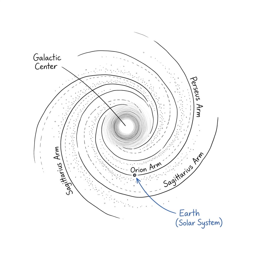
Spiral Shape Galaxy:- Such galaxies have arms e.g. Milky way galaxy have 6 arms. Our solar system lies in Orion path. Similarly our nearest galaxy Andromeda.
Milky way
Elliptical Shape:- e.g. Cygnus A
Irregular shape Galaxies:- Such galaxies do not have any particular shape e.g. Magellanic Clouds Large and Small. These two galaxies are satellite galaxy of milky way.
There is a presence of high gravity in the centre of galaxy which are mostly black holes e.g. name of the black hole present in the centre of galaxy, milky way is Sagittarius A.
Galaxies have their peripheral which are called cradles or birth place of star from where new stars are formed.
Quasar is one the brightest object in universe. It is extremely bright centre powered by super massive black hole.
Our Milky Way galaxy is a part of local group which contains 52 to 54 galaxies. Local group is part of Virgo Supercluster.
Virgo Supercluster is part of Laniakea Supercluster. Eventually part of Pisces-Cetus Supercluster Complex.
Stars
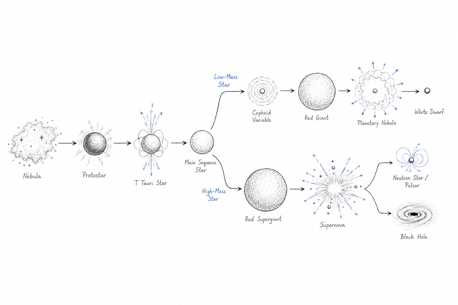
Stars are those celestial bodies which have their own light which comes out due to nuclear fusion which take place at the core of the star. The life cycle of star is as follows:-
Life Cycle of Star
Nebula
Star forming Nebula is vast cloud of gas of dust in space where new stars are born. Gravity causes parts of the cloud to collapse which forms Proto Star out of Nebula.
Proto Star
A Proto Star is a young, developing star formed when a dense region within a Nebula collapses under gravity. It is not yet a true star because nuclear fusion has not started in its core. As it contracts and heats up, it eventually reaches the temperature needed for fusion.
T Tauri Stage
It is a very young star in the final stage before becoming Main Sequence star. It has a age usually less than 10 million years.
Main Sequence Star
A main sequence star is a stable star that produces energy by converting hydrogen into helium in its core through nuclear fusion. This is the longest stage in the star lifecycle. Our sun is in main Sequence star stage.
Our Sun had become main sequence star about 4.5 billion year ago.Cepheid Variable:- It is not a separate stage in the life cycle of all stars. It is type of pulsating star that is usually found after the main sequence phase. The star repeatedly expand and contracts, causing its brightness to vary regularly.
Red Giant and Super Red Giant Star
Red Giant:- Small and medium size stars, which loose their fuel gradually, which has mass up to maximum 8 solar masses enter into the stage of red giant. In this star become much larger then the main sequence star.
Super Red Giant:- Large size of stars which consume their fuel faster than small stars, which have mass more than 8 times of solar mass enter into the stage of super red giant. In which size of star become very large due to nuclear fusion of heavier elements like helium, carbon, oxygen, etc in successive stage.
Planetary Nebula Stage
Small stars enter into this stage after red giant stage. In this small core remains at the centre and the outer peripheric gradually blows away.
White Dwarf
It is end stage of small stars.
Super Nova Explosion Stage
After super red giant stage large stars enter into super nova stage i.e. super massive explosion. It produces and disperses heavy elements such as iron, gold, uranium, etc
Neutron Star
It is formed when mass of dying star is aged to 25 solar masses.
Pulsor Star
It is subtype of neutron star. Neutron stars are made up of neutrons. When it releases huge amount of radiation it is called pulsor star.
Black Hole
It is end stage of dying star if it has mass is more than 25 solar masses (20 to 25 solar masses). Black hole are the reason of massive gravity even the light can't escape. If it goes or enter into event horizon of black hole. The centre of the black hole is called Singularity no space, no matter, no time.
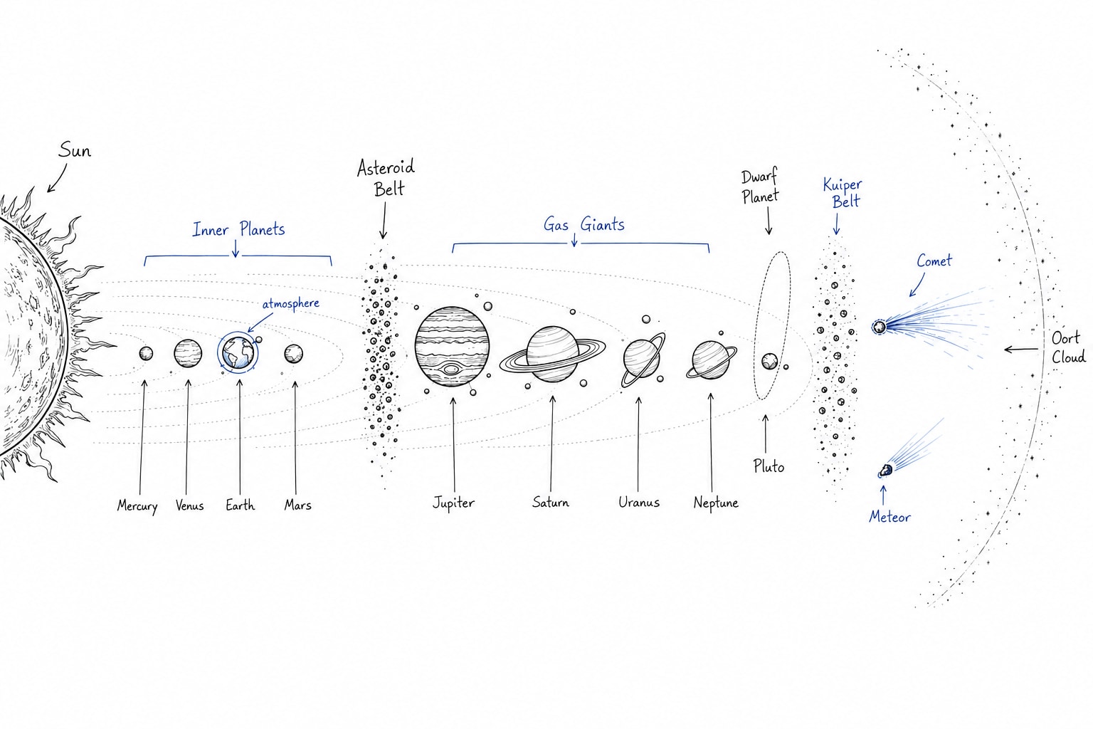
Solar System
Sun (Star)
Planets (Satellites)
Dwarf Planets
Asteroids
Meteors
Comets
Kuiper Belt
Oort Cloud
Solar System
Sun
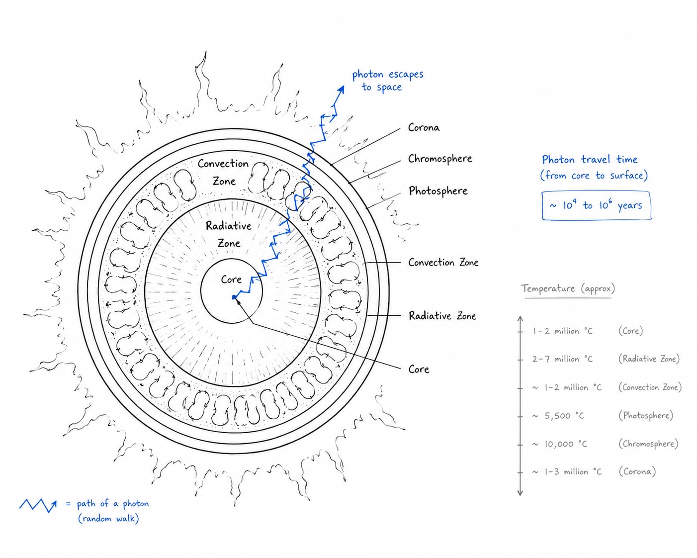
Sun
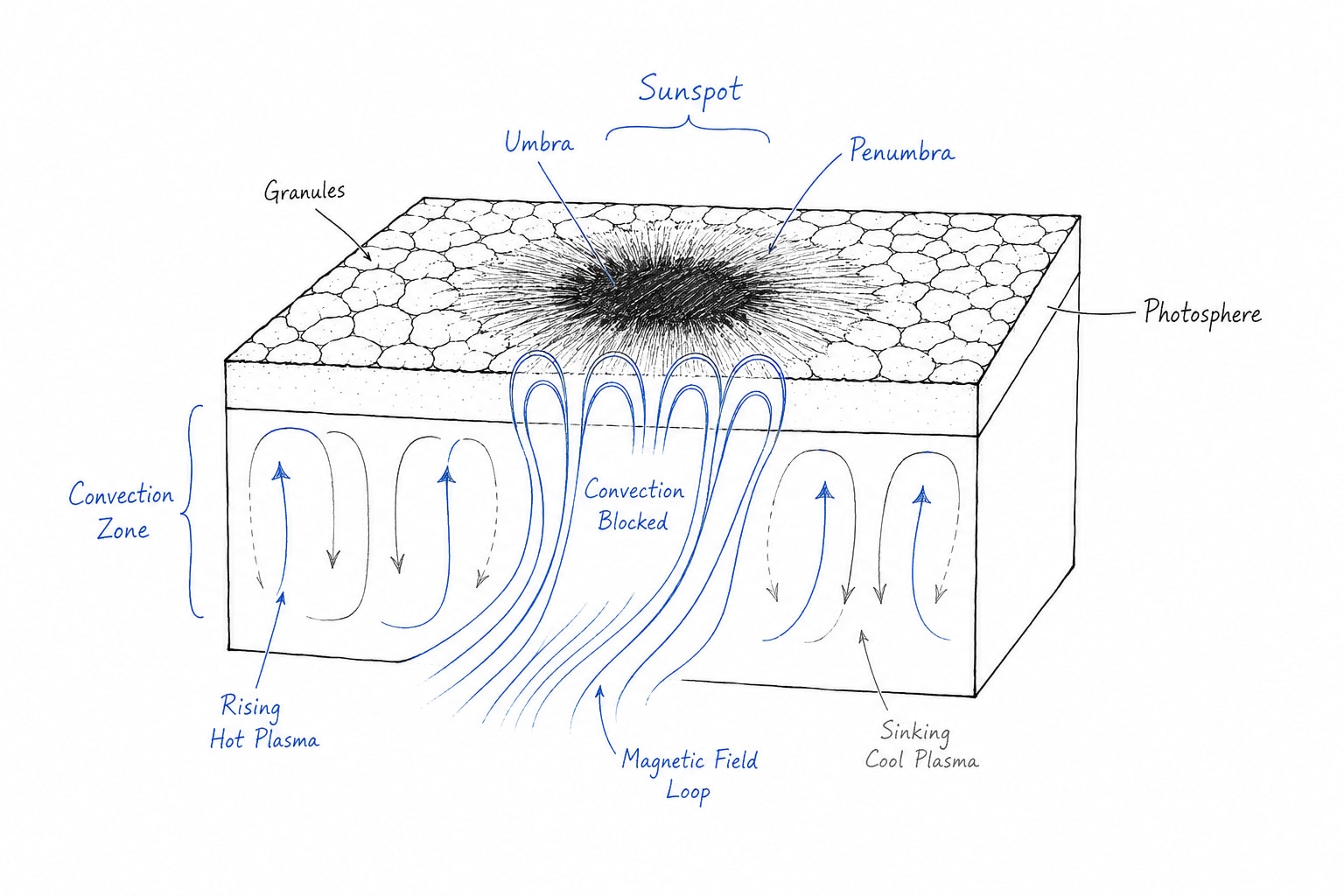
Sun Spots
Sun spots are those special places which have developed on sun surface which have abnormally high electromagnetic activity. This is why the amount of heat of from these areas is lesser than the average. These have relatively low temperature. The darkest part in the centre of the sun spot is called Umbra and relatively less darker part is called Penumbra.
Sun spot goes from minimum to maximum in 11 year cycle. In every 11th year sun's magnetic polarity also reverses.
When the number of sun spot is recorded maximum the amount of radiation is also recorded maximum and vice-versa.
sun spots
Solar winds
Solar winds are a stream of plasma particles that are ejected form the sun's atmosphere. They are caused by the sun's magnetic field and they can cause Aurora on earth poles.
Solar Flares
Solar flares are on intense burst of radiation that is caused by the release of magnetic energy from sunspots.
Solar Prominence
These are enormous, arching structure of hot, glowing gas that extends from the sun's surface to its outer atmosphere. They are often seen during total solar eclipse.
Planets
Heliocentric theory was given by Caupenieus Kepler was the first one to explain and prove that planets are revolving around the sun on elliptical path. That is why there is a concept of Periheran and Epiheran. Earth reaches its Epiheran on 4thJuly and Periheran on 3rd Janurary.
Definition of Planet
Objects which revolved around sun
Should have sufficient gravity to give spherical shape
It must have clear neighbourhood (of orbit)
Mercury
Mercury is the first planet from the sun.
It is about 55% the mass of the earth.
It has about 38% of earth's gravity.
It has prograde rotation i.e. west to east.
It has second hottest planet of solar system.
It has no moon.
Venus
It is second planet form the sun.
It is considered as earth's twin because of almost similar size and mass.
It has retrograde rotation i.e. east to west.
It completes its one rotation in 243 earth days i.e. the slowest rotation among the major planets.
It completes its one revolution in 225 earth days, thus is a day is longer than the year on Venus.
Venus is hottest planet of solar system because it has very high concentration of green house gases CO2 i.e. about 96.5% if it rains of Venus it is mainly carbonic acid or sulphuric acid.
The average temperature of Venus is 465o C.
It is brightest planet also. It is called morning and evening star.
It is called goddess of beauty.
It has no satellite.
Earth
Third Planet.
Its average density is 5.5g/cm3.
Only planet where water is found in liquid state. It is because of its ideal temperature.
It has ideal temperature because it is situated at a ideal distance from the sun. This ideal distance is called habitable zone or goldilock zone.
It has one natural satellite called moon.
Moon was formed 4.4 billion years ago where as earth was formed 4.5 billion years ago.
Moon revolve around the earth in about 27 days and almost same it take to complete its one rotation also.
Earth average orbital speed is about 30 km/s.
Escape velocity form the earth is 11.2 km/s.
Mars
It is fourth planet from the sun.
It is called red planet because it contains red rock that is because of oxidation.
It complete its one rotation in 24 hours and 37 minutes i.e. very close to earths rotation (Earth sideral day is 23 hours 56 minutes 4 seconds, Earth solar day is 24 hours )
Mars has 2 moons. Deimos and Phobos.
Earlier mars had strong magnetic field (billion of years ago) but now it does not have strong magnetic field.
Largest volcano of solar system is Olympus Mons and this is on mars.
Jupiter
It is fifth planet from the sun.
It is gas giant
It has 318 times greater mass then the earth.
It has faint ring.
It has 95 moons
It has largest planet of solar system.
It is made up of hydrogen 90%, helium 10%. It has traced amount of methane ammonia and water vapour.
It complete one rotation in 9 hours 56 minutes. This makes it the fattest rotating planet in the solar system.
It completes its one revolution in 11.86 years on an average 12 years. That's why Khumb Mela is celebrated after every 12 years at 4 places
Haridwar, Ganga river
Prayagraj , Ganga river
Ujjain , Sipra river
Nasik, Godavari river
Its important moons are
Io - most volcanically active body in the solar system.
Europa
Ganymede - It is bigger than mercury. It is largest moon in the solar system.
Callisto
Saturn
It is sixth planet from the sun.
It is gas giant.
It has prominent ring.
It have 270+ moons. Major moons are:
Titan - It is second largest moon of solar system larger than mercury.
Enceloadus - It is covered with ice.
Rhea
Lapetus
Dione
Mimas
Second largest planet in solar system made of 96% hydrogen and 3% helium.
It complete its one rotation in 10.7 hours or about 10 hours 33 minutes.
It complete its one revolution in 29.5 years.
On north pole of Saturn storms are developed in hexagon shape.
The density of Saturn is less than water
Uranus
Seventh planet
It is ice giant.
It has 28 moons. Important moons are
Titania - Largest moon of Uranus.
Obreon
Aerial
Miranta
Most of the moons are name after character from William Shakespeare plays.
It colour is blue-green. The reason behind blue of Uranus is good presence of methane gas. Methane gas absorbs red light and reflects blue-green light.
Uranus is third largest by diameter and fourth largest by mass.
It's rotation is retrograde i.e. east to west alike Venus.
It complete it's one rotation in 17 hours 14 minutes and revolution in 84 years.
Uranus is titled on it axis by about 98o.
It has also a faint ring.
Neptune
It is eight and farthest form the sun.
It is ice giant.
It has about 16 moons. Its famous moons are-
Proteus
Larissa
Neried
It has faint rings.
It has blue colour.
It rotates west to east and completes it's one rotation in 16 hours and its complete one revolution in 165 earths year.
Neptune experiences fattest wind blow of our solar system sometimes faster than 2000 km/h.
Dwarf Planets
Dwarfs planets are those one which
which revolve around the sun
have spherical shape
but do not have clear neighbourhood orbit.
There are five dwarf planets.
Pluto - Largest one.
Make Make
Howme
Eris
These four lie in Kuiper Belt
Ceres - Smallest dwarf planet.
It lies in asteroid belt
Asteroid Belt
Asteroid belt is region of solar system which lies between mars and Jupiter. It contains millions of rocky substances including ceres. These are also revolving around the sun.
Meteors
Meteors are rocky substances which are attracted by earths gravity and enter into earths atmosphere. There in mesosphere due to high frication of air it catches fires and it is called shooting star. Most of them are completely burn and change into ashes and few of them hit the earth surface. If number of meteors come together and start burning in mesosphere it is called meteor shawers.
Comet
Comet are small celestial bodies primarily made up of ice and dust. when it approaches to the sun while revolving it its head starts glowing that glowing head is called coma because of evaporation of the ice it develop tail i.e. called dust tail. Its central rocky part is nucleus.
Comets come from mainly two places
Kuiper Belt i.e. located beyond Neptune. From here short period comets come
Oort Cloud - from here long period comets come which have time greater than 200 years.
The very famous comet called Halley's comets come after 76 year last appeared in 1986. It is expected again in 2061.
Oort Cloud
It is cloud which surrounds or envelops entire solar system. It was first proposed by Jan Oort in 1950s.
Earth
Earth has geoid shape. It's geoid shape is explained as
Earth like shape which is unique.
It has spherical shape/ Spheroid but it is not perfect square because it has flattening on the pole because of maximum centripetal force and maximum centrifugal force.
Motion of Earth
Rotation
Earth rotates on axis and complete its rotation in 24 hours called solar day or in 23 hours 56 minutes and 4 seconds called sideral day. Earth completes its rotation on its axis which is titled at 23.5 day at present. However, according to Milankovitch cycle the earth tilt axis values between 22.1o and 24.5o in a time span of 41000 years.
There is another motion on the earths axis which occurs due to wobbling in the earth. This motion is called precision which complete one cycle in a time frame of 26 thousand years.
Earth Revolution
Revolution is motion of earth around sun in its orbit earth completes its one orbit in 365.6 days because of orbiting motion i.e. revolution as well as tilt of earth it experiences seasonal change.
Revolution and rotation both cause dynamic changes on the earth surface rotation causes day and night as well as flatting on the pole and belonging on equator.
Eccentricity is about the change in the shape of Earth's orbit which goes from near circular to highly eccentric in time frame of 1 lac years.
Eccentricity/ Obliquity/ Precession influenced the amount of insolation reaching on earth. In other words it affect climate change.
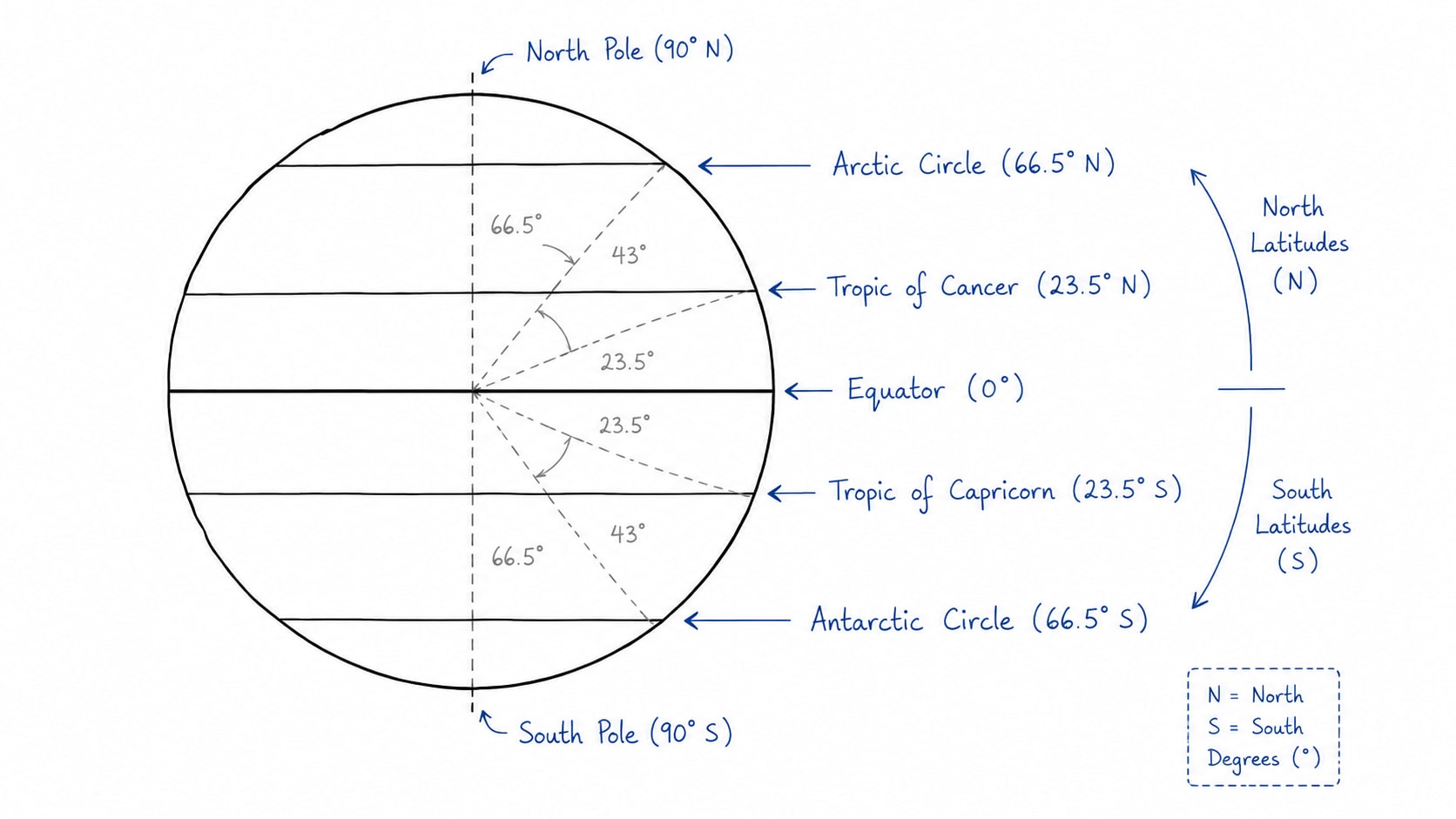
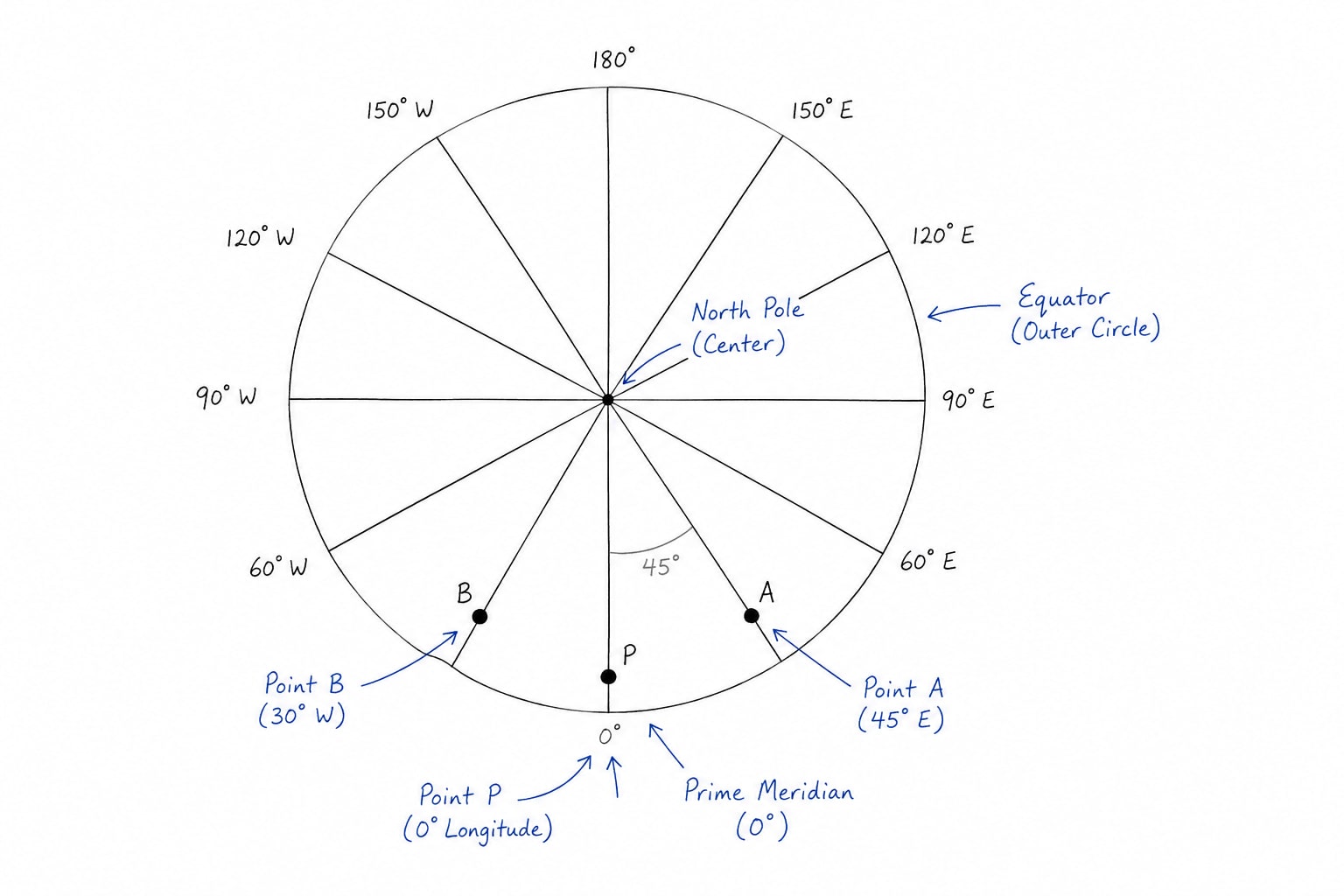
Longitude and Latitude
Latitude
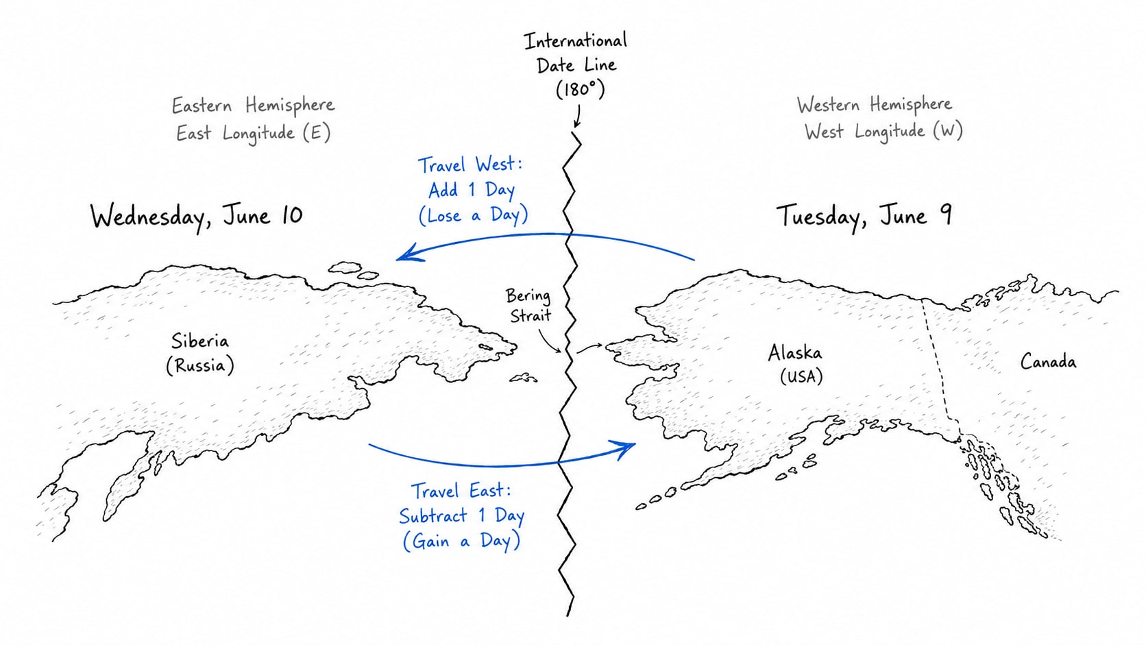
Time Zones
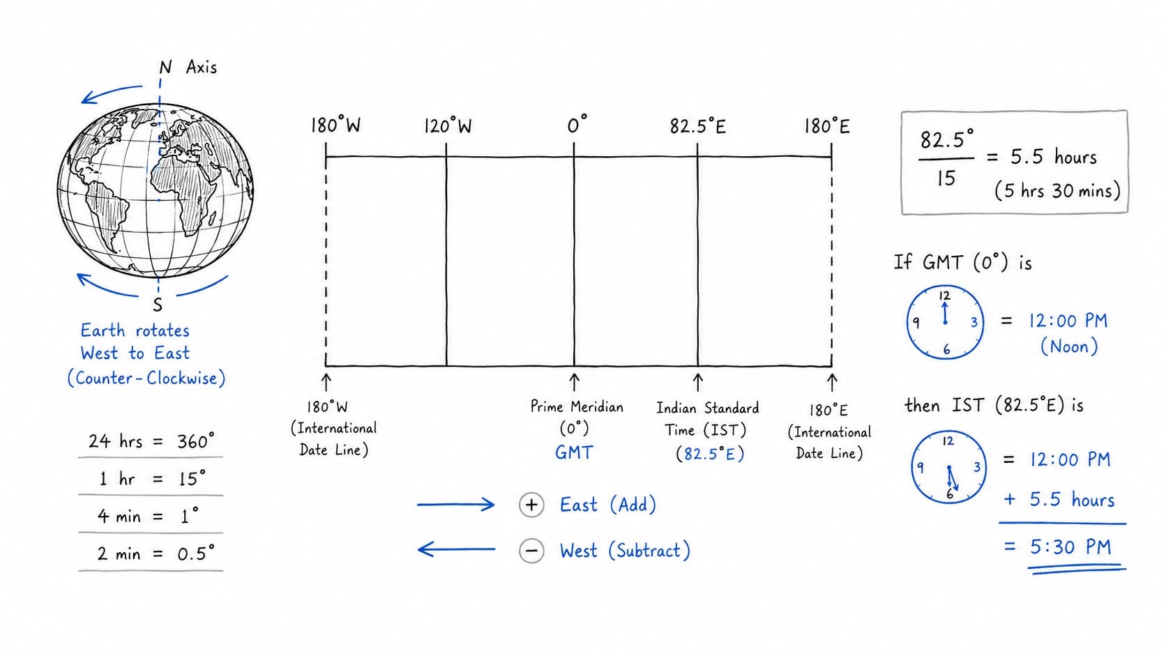
Many countries in the world have more than one time zone because of high latitudinal extend or east to west expansion of their geographical area. e.g. Russia have more than 10 time zones, US have more than 5 time zones. However, France has maximum number of time zones specially because of its colonial past. India has only one time zone i.e. IST (Indian standard time) is based on longitude of 82.5o E near Mirzapur/ Parayraj Uttar Pradesh. This means that the entire country form Gujrat from in west to Arunachal Pradesh in the east uses the same clock time. However, the longitudinal distance between the western and eastern most part of India is about 30o. That's why a debate is going on in the country on having two time zones in India.
Why India should have 2 time zone?
Huge difference in sunrise and sunset
Dong on Arunachal Pradesh experiences sunrise during summers at 4 AM approximately
Bhuj of Gujrat experience sunrise around 6 AM during summers
As a result sun rises nearly two hour earlier in eastern India than the western India. Due to this people in North east India start their day much earlier besides this offices and school open after sunrise by a large margin which causes loss of or wastage of valuable day light
Energy Savings: Research by India's scientific agencies and studies by the government expert committee suggest that advancing time in the north east could save electricity. The national institute of advance studies i.e. NIAS, Bengaluru estimated annual savings of around 200 to 270 million units if eastern India adopts a separate time zone. By doing this less artificial light is needed in the evening.
Better productivity and health: People naturally function according to daylight this is called scardian rhythm. In the north east early sunrise but late office timing create a mismatch. Children often go to school long after sunrise. Workers loose their productivity because of late start in the morning. Thus, aligning clock time with sunlight can improve sleep cycle, work productivity and health outcomes.
Many large countries have multiple time zones e.g. Russia, US, Canada, Australia, etc.
Why India should not have two time zones?
Railways and Aviation safety: India operates one of the worlds largest railway networks. Historically before independence different cities of India had different time zones like Bombay time, Calcutta time, Madras time, etc. This was creating a lot of confusion. Today over 13 thousand passenger trains run daily and thousands of flights operate annually. Creation of two time zones could increase scheduling complexity and risk of error.
Administrative complexities: If Assam follows one time and Bihar another it would make very difficult to operate government offices, banks, courts, national examination, stock markets etc.
Economic Integration: India is highly integrated economically. Thus every business prefer one clock, one market opening time and one office schedule. Multiple time zones may increase coordination cost.
Alternate solution
Instead of changing clock or time zones we can reschedule office time, school time and most of thing 1 or 21 hour advance. e.g. nation wide schools can be started at 7 AM instead of 8 and offices and banks could be started at 9 AM instead of 10. e.g. Similar arrangement is done in Chai Bagan which is one hour ahead of IST informally.
In 2014 the government appointed committee led by scientist Dr. R Kasutirandan had given his report by saying that benefit of second time zone does exist but operational and safety challenges specially for railways outweighed the gains. Thus he recommended retaining a single time zone while allowing flexible working hours.
Geomorphology
Earth's interior
Continental Drift theory
Plate Tectonics theory
Volcanic
Earthquake
Mountains, Plateaus, Plains
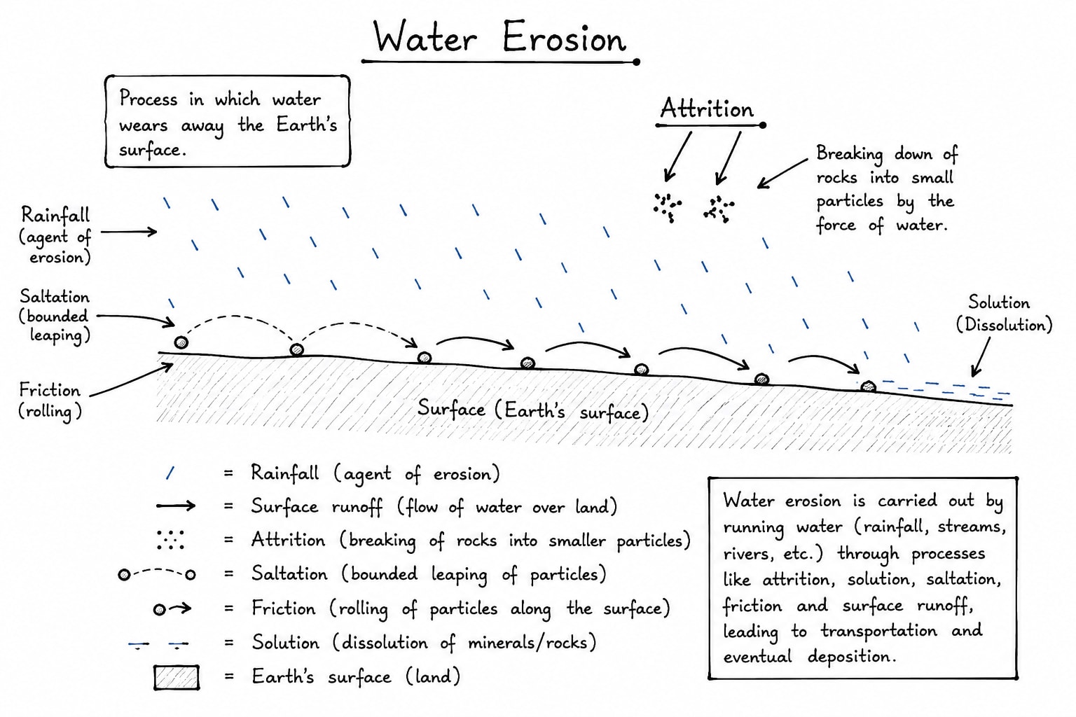
Weathering and Erosion
Rock and Rock cycle
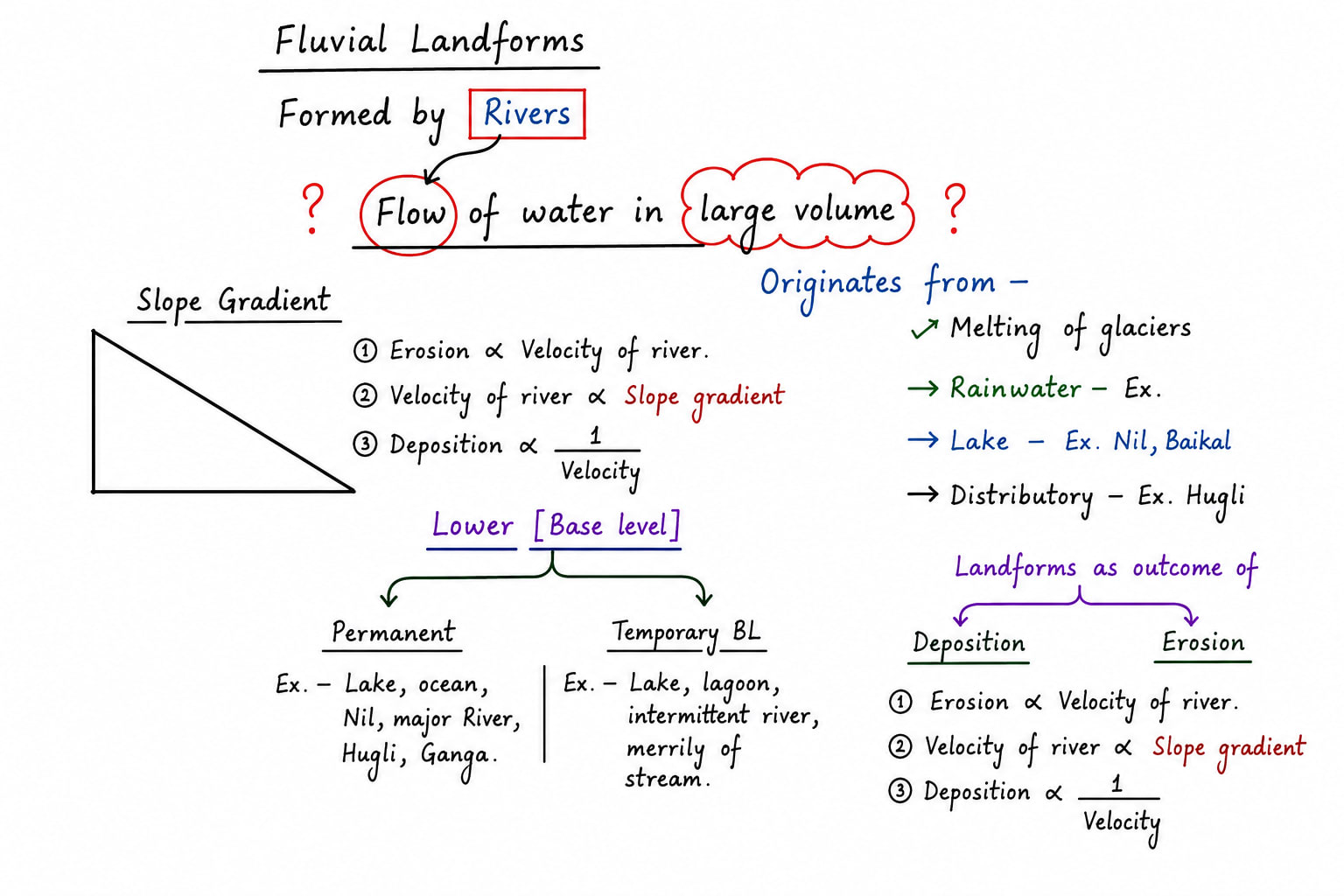
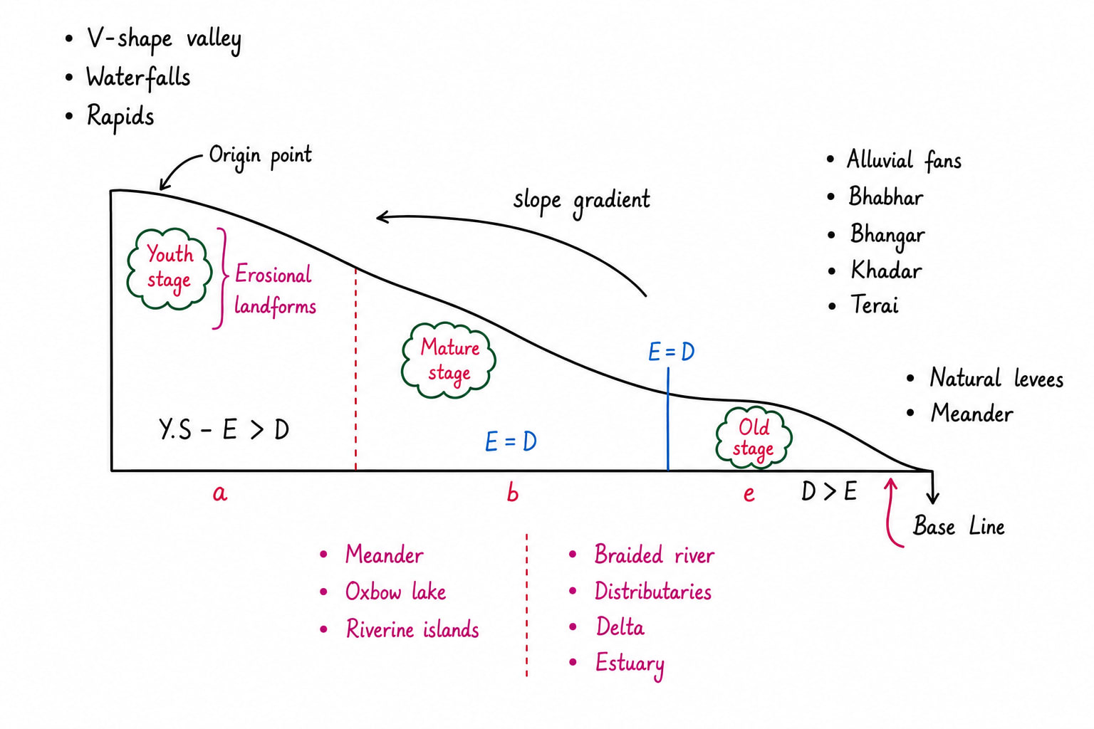
Landforms by
Rivers
Winds
Glaciers
Ground Water
Costal waves
Earth's Interior
According to the various theories explaining origin of solar system and planets the earth also come out from the same nebula which had formed our solar sun. The important theories include
Nebular Hypothesis: It is most accepted hypothesis today it was given Immanuel Kant in 1755. It was later developed by Laplace in 1796. It's main idea is that the solar system was formed form rotating cloud of gases and dust called Nebula. The gravity caused the centre of nebula to collapse. It formed sun at the centre and the remaining materials formed planets.
Planetesimal Hypothesis: It was proposed by Chamberlin in 1905.
Tidal Hypothesis: It was given by James Jeans and Jeffreys in 1917.
Binary star Hypothesis: It was given by Russell.
Dust Cloud Hypothesis: It was given by Gerard Kuiper.
If we consider any of these hypothesis right and we know that earth was formed 4.5 billion years ago when it was hot semi molten and later on solidified then the earth surface should be smooth plane surface but it is not so. The earth surface is highly irregular and full of relief features mainly due to endogenic forces which operate form earths interior.
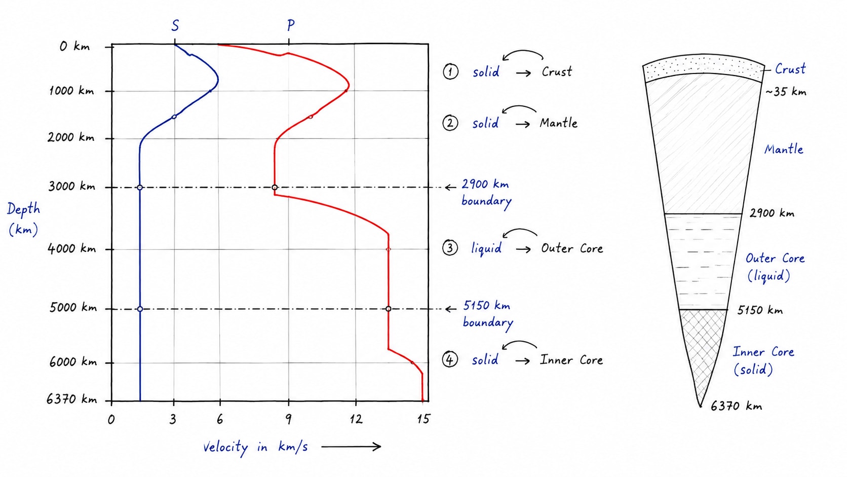
Study of Earth Interior
The centre of earth which is called core has a depth 6370 km no technology can led us up to such depth to make direct observation. This is why scientist used both direct and indirect methods to understand earth interior because the difficulty level to reach up to the core is too high to reach.
Direct Methods
Deep Mining:- Till date latest scientific tools and technology we have reached up to the depth of 8 to 12 km only. However, it suggest that with increasing depth temperature and density increases.
Study of temperature:- with increasing depth temperature increases by 1oC/32m but this rate of increase in temperature is restricted only up to 8km beyond that temperature increases but with relatively slower rate. That's why calculation suggest that at the depth of core temperature is about 5000 to 5500oC.
Causes of such high temperature
Trapped primitive heat since the formation of earth in its interior.
Concentration of radioactive elements like Uranium and Thorium which decays and produces high amount of heat. The maximum concentration of radioactive elements is in the upper mantle.
Conversion of gravity into heat.
Study of Pressure:- with increasing depth pressure increases. Pressure is force per unit area which is applied upon the lower surface by overlaying surface. This is why core bears maximum pressure followed by mantle followed by crust. To be more precise inner core maximum pressure followed by outer core, lower mantle, upper mantle, lower curst and upper crust.
with increase in pressure
temperature increasing with increasing depth
melting point of the rocks also increases.
with increasing depth density of rocks gradually increases this is why there melting point also high e.g. the top most layer of the earth surface is made up of silica and aluminium that has least density the middle layer is made up of silica and magnesium whereas innermost part is made up of nickel and ferrous.
Earth surface rocks has average density of 2.6g/cm3 to 3g/cm3 whereas core has 10-30g/cm3 this is why average density of 5.5g/cm3
Indirect methods
Study of Meteors
Meteors helps us in gaining direct observation. Meteors are rocks flying in space attracted by earth's gravity and hit the surface of earth as a solid mass. Meteors are the remnants of the past which reviles the process of formation of solar system as well as earth. In 99% cases these meteors are made up of iron and nickel which gives clear indication that the earth core should also be made up of iron and nickel.
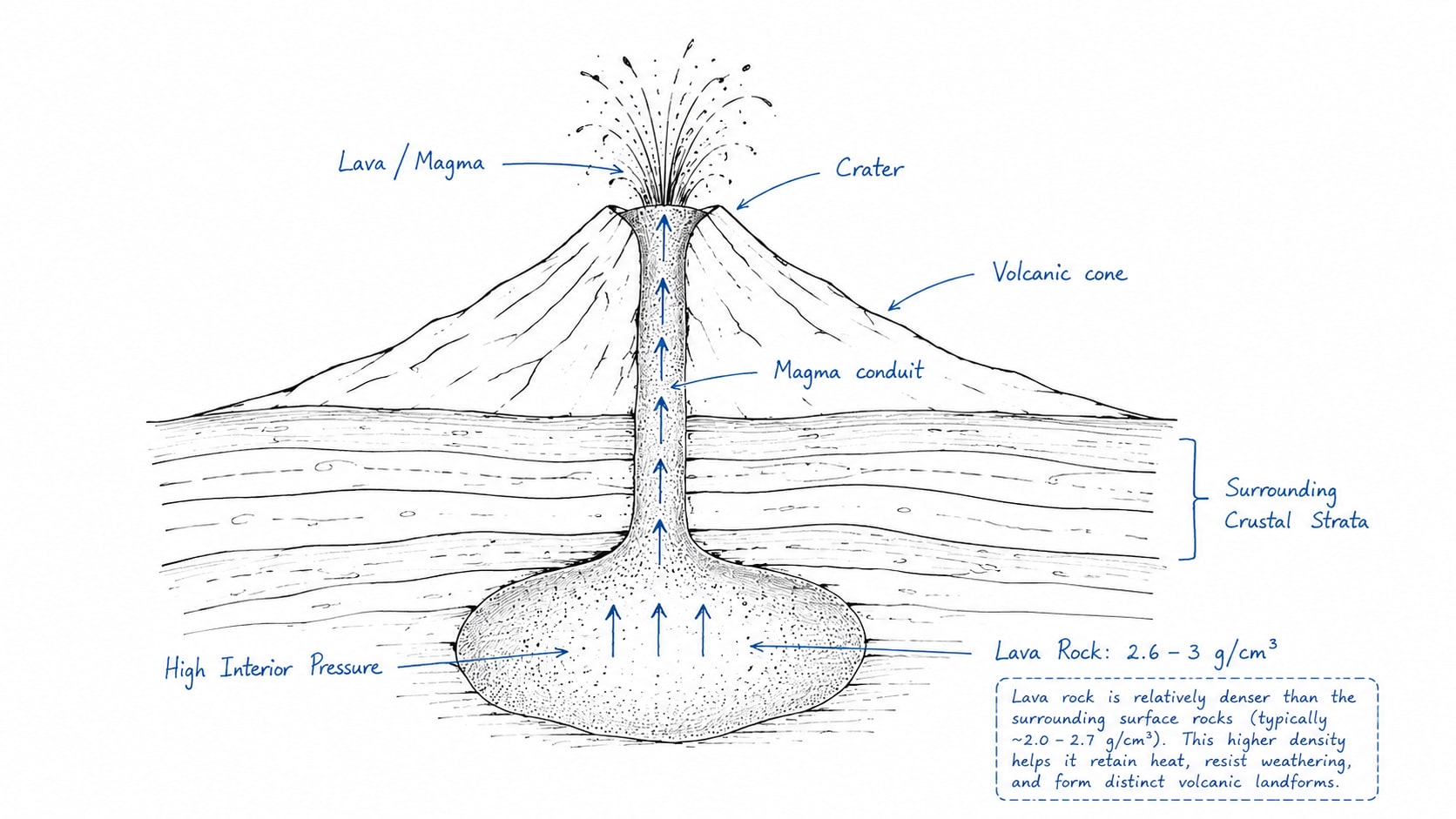
Study of Volcanism
Volcanic eruption is eruption of molten rocks from the interior with burst which clearly suggest that in the earth interior temperature, pressure and density all three increases with increasing depth
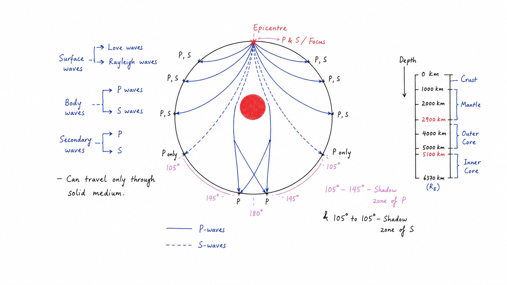
Study of Seismic waves
Seismic waves are most effective method to know about interior because these are the only methods to pass through the entire interior of earth. Seismic waves are of two types:-
Surface waves:- Surface wave originates from epicentre and do not travel thorough interior of earth. It travel only on the surface. These are of two types L waves and R waves
Body waves:- Body waves originates from focus and it travel only through the interior. These are two types of:-
Primary waves of P waves
Primary waves carry maximum energy and have maximum velocity and shortest wavelength.
It can pass through solid, liquid and gaseous medium.
It refracts when medium is changed.
S waves
S waves carry lesser amount of energy and velocity than the P and its wavelength is also longer than P.
It can only through solid medium.
It also refracts when medium is changed.
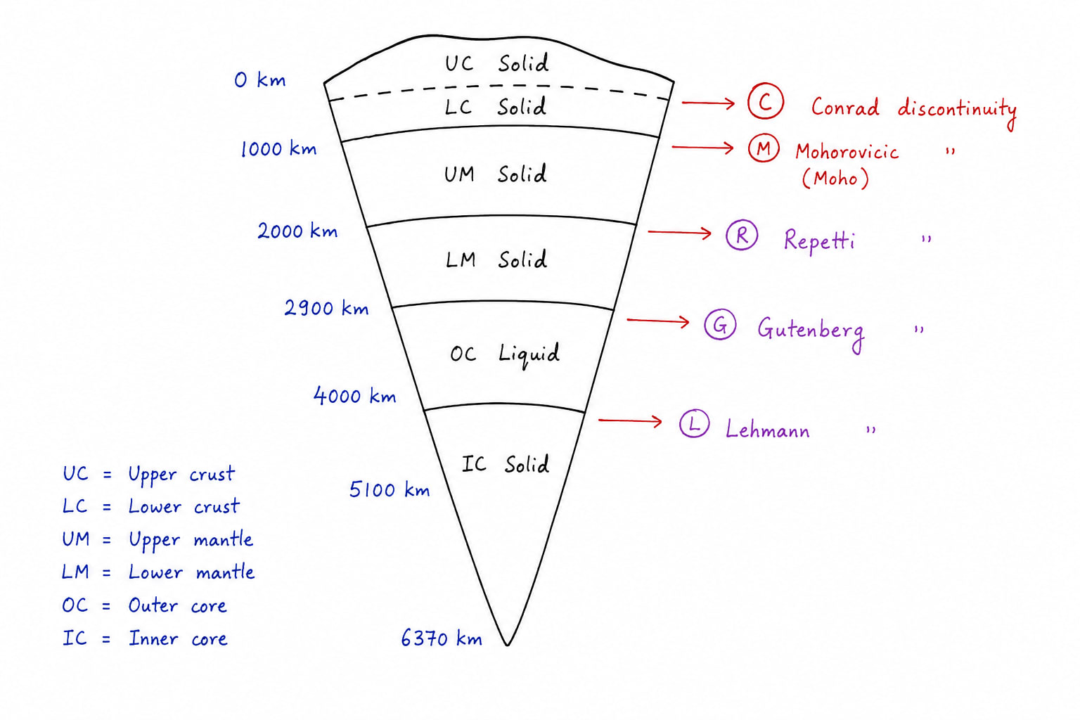
Structure of Earth Interior
The study of P and S waves suggest that earth interior is not homogenous medium it is heterogenous. It is divided primarily into three layer i.e. crust, mantle and core.
Crust
Further study suggest that crust has also two layers, upper crust and lower crust. Upper crust is further divided into two parts
Oceanic Crust:- It has thickness of 0-10km. It is primarily made up of basalt.
Continental Crust:- Continental crust has thickness of 35-40km. It is primarily made up of granite.
upper crust is separated from the lower crust by Conard discontinuity.
Mantle
Mantle has two parts
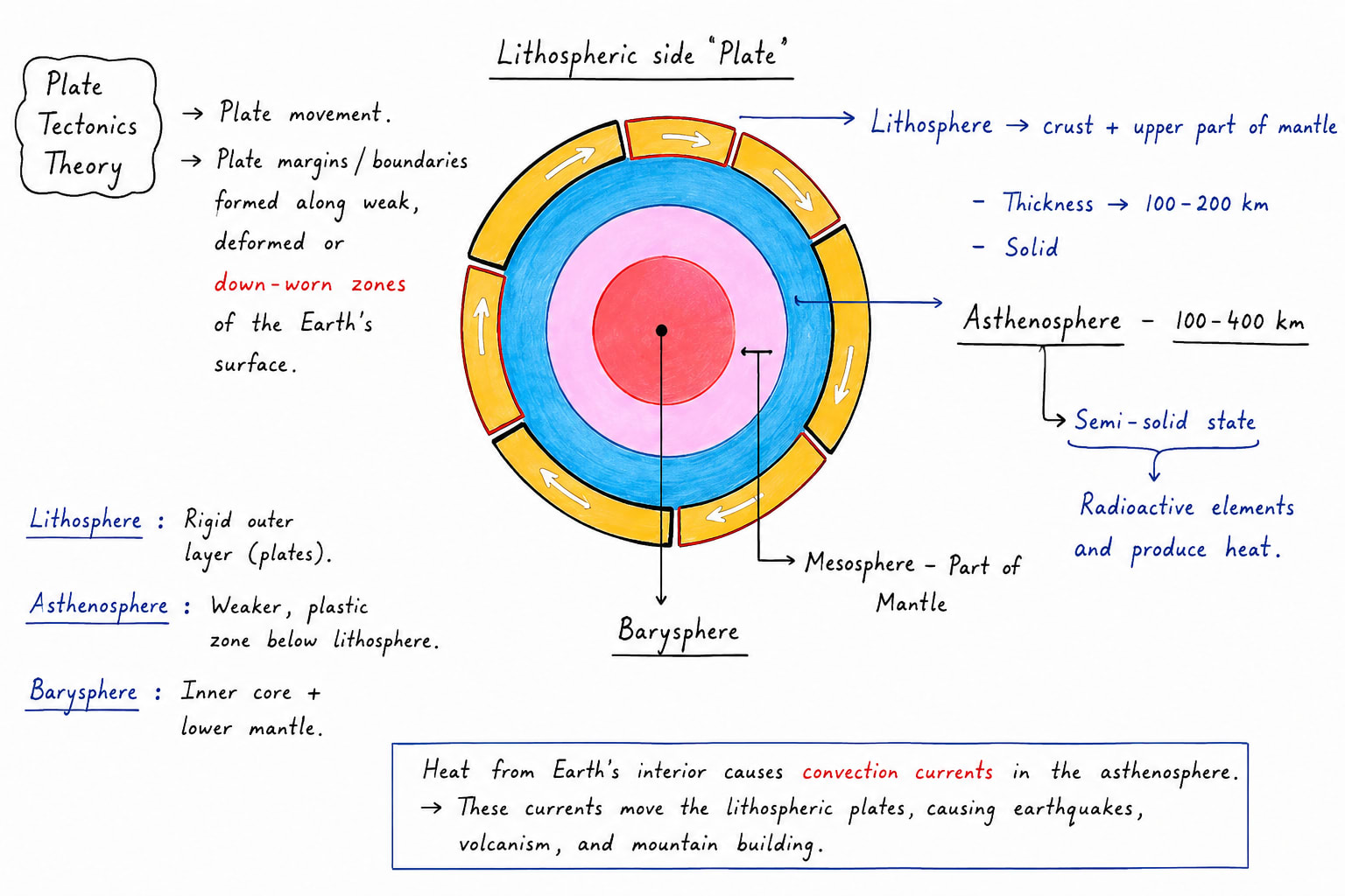
Upper Mantle:- Upper mantle is separated from lower crust by mohorobic discontinuity. It is also called aesthenosphere.
Lower Mantle:- Lower mantle is separated from upper mantle by repiti discontinuity. It extends up to depth of 2900 km.
Core
Core is divided into two parts
Outer core:- It is in liquid state. It extends from 2900km to 5150km. This layer is responsible from electromagnetic shield of the earth. It is separated from lower mantle by Guttenberg discontinuity.
Inner Core:- Inner core is in solid state. It extends between 5150km to 6370km.
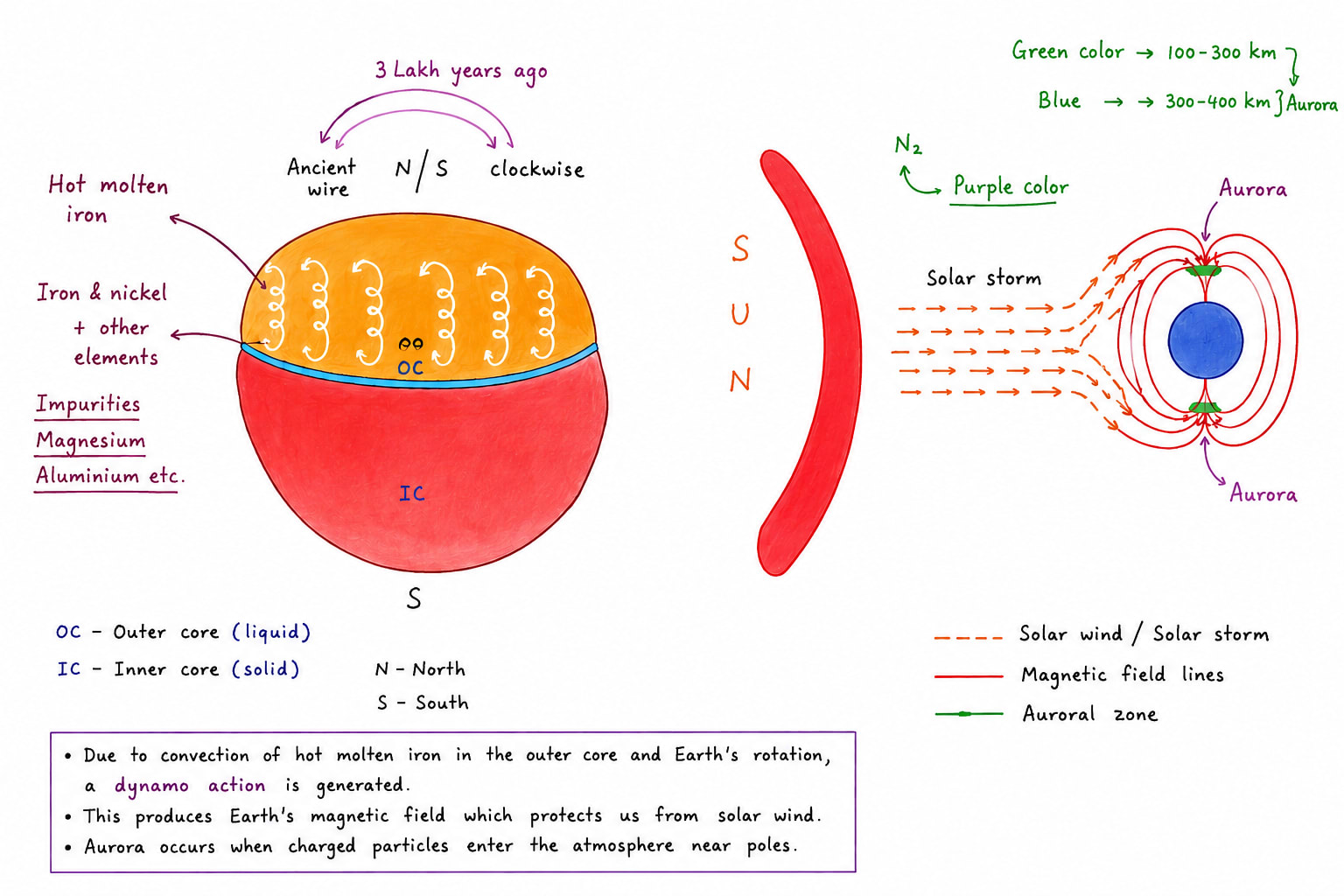
Geomagnetism
Geomagnetism refers to earth magnetic field which makes the earth behave like a giant bar magnet with magnetic north and south poles. The magnetic axis is inclined by about 11o to the earth's rotation axis. This magnetic field extend into space forming the magnetosphere which surrounds and protects earth.
Causes of Geomagnetism
The earth's magnetic field is generated by geodynamic mechanism operating in the liquid outer core
The outer core consist mainly of molten iron and nickel.
Convection currents caused by heat escaping from the core lead to the movement of these electrically conductive fluids.
Combine with the earth's rotation, Coriolis force, these motion generate electric currents.
The electric current in turn produces earth's magnetic field.
Impact of Geomagnetism
Protection form solar radiation.
Deflects charged particles from the sun, preventing harmful radiation form reaching the earth surface.
Formation of Auroras:- Interaction between solar winds and magnetic field produces auroras near polar regions.
Geomagnetic Storms:- Strong solar activity can disturb the magnetic field affecting satellite, ISS, communication system, GPS and power grids.
Magnetic Navigation:- Compasses aligned with earth's magnetic field and aid navigation.
Importance of Geomagnetism
Essential for the existence and evolution of life by shielding earth from solar and cosmic radiation.
Helps in navigation of ships, aircrafts, mitigatory birds like Amur Falcon which flies from Magnolia, Southern Siberia, Northern China to South Africa, Zimbabwe, Namibia and Botswana via India, Nagaland where it rests for few weeks or months. Similarly, Siberian birds coming from Siberia to Bharatpur of Rajasthan.
It provides clues about the earth's interior and core dynamics.
It support space weather forecasting and satellite operations.
Recent Development
Scientist continue to monitor the weaking and shifting of the magnetic field particularly the South Atlantic anomaly where magnetic intensity is usually low.
European space agencies, swarm satellites to study changes in earth's magnetic field to improve understanding of the earth's interior core process and space weather.
Conclusion
Geomagnetism is dynamic phenomenon generated by earth liquid outer core beyond enabling navigation, it act's as a protective shield against harmful solar radiation and provide critical insights into earth interior.
Auroras
Auroras are spectacular natural light occur in the upper atmosphere, ionosphere near the polar regions. These are known as aurora borealis in the northern hemisphere. These are also called northern lights. In southern hemisphere these are called aurora australis or southern lights.
Causes of Auroras
Auroras result form the interaction between the solar winds and earth's magnetic field
The sun continuously emit charged particles called the solar winds.
The earth's magnetosphere channels these particles towards the polar regions.
The particles collide with gases in the upper most atmosphere mainly between the altitude of 80-400km i.e. ionosphere.
There is presence of oxygen and nitrogen gases which become excited due to this interaction and release energy in the form of visible light.
Colours of Auroras
Green Colour:- It is mainly due to the presence of oxygen between 100-300km. It is most common colour.
Red Colour:- It is because of oxygen between 300-400km.
Blue and Purple Colour:- It is because of Nitrogen.
Importance of Auroras
Indicator of space weather:- Auroras helps scientist to monitor solar activity and geomagnetic storm.
Evidence of earth-sun interaction:- Demonstrate the functioning of the earth's magnetic field and magnetosphere.
Scientific Significance:- Provide insights into atmospheric physics, plasma dynamics and solar terrestrial relation.
Importance for technology:- Aurora event often accompany geomagnetic storms that can affect satellites, ISS, GPS, radio communication, power transmission, etc.
Ecommerce and tourism value:- Auroras attract millions of tourist to the countries of north like Canada, Norway, Iceland, Finland to watch northern lights specially in the months of November to February. In southern hemisphere tourist visit Chile, Argentina, New Zealand, etc. in the months of May to August.
Conclusion
Auroras are visible manifestation of interaction between sun and earth. Beyond this scenic beauty they provide valuable information about space weather, geomagnetism and other atmospheric process making them important for both scientific and technological preparedness.
Continental Drift Theory
This theory was given by German Meteorologist named Alfred Wegener in 1912 and elaborated in his book the 'Origin of continents and Oceans' in 1915. The theory states that the present continents were once joint together as a single super continent called Pangea, which later broke apart and drifted to their present positions.
This theory was the first scientific experiment or attempt to explain the similarity of coastlines, rocks, fossils and geological structures found on different continents.
Concept of Continental Drift Theory
According to Wegener:-
Around 250 million years ago all land masses formed one giant super continent called Pangea.
Pangea was surrounded by a super ocean called Panthalassa.
A shallow sea was formed when Pangea got divided into 2 parts. The northern part of Pangea, situated north to Tethys sea was called Laurasia and the southern part was called Gondwanaland. Northern part is also known as Angara land.
Further rupturing of Laurasia formed North America and Eurasia.
Further rupturing of Gondwanaland formed South America, Africa, Antarctica, India, Australia and Madagascar.
Because of rupturing of continents and their respective movement formed different oceans also like:-
Between North America and Eurasia intrusion of Panthalassa water formed North Atlantic and later on South Atlantic was formed between America and Africa.
Indian ocean was formed between Africa, Australia and Antarctica.
Artic ocean was formed when the Panthalassa water near North pole was surrounded by North America and Eurasia almost from all the sides.
Pacific ocean i.e. largest ocean on the plant is remanent of the old Panthalassa.
Over geological time due to fragmentation of the land masses and their gradual shift has led to the present arrangement of the continents.
Wegener believed that the continents are composed of lighter rocks i.e. silica and aluminium, floating over dense oceanic crust which is made up of silica and magnesium allowing them to move.
Evidences supporting this theory
Jigsaw fit of continents:- The coastlines of continents appear to fit together like pieces of a puzzle. e.g. the eastern coast of Brazil/South America matches closely with the western coast of South Africa. The best fit is obtained by matching continental shells rather than present coastline. This suggested that these 2 continents where once joint.
Geological Evidence:- Rock formation and mountain belts of similar age and composition are found on opposite side of ocean e.g. the Pre-Cambrian rock formations occur in Africa and South America. These similarities indicate a common geological stream
Similarly the Appalachian mountain of North America continue into Norway also a part of Caledonian mountain range. It suggest that these mountains were formed when North America and western Europe were together.
Fossil Evidences:- Identical fossils are found on continents now separate by oceans. e.g.
Mesosaurus:- Fossil of Mesosaurus are found in South America. It was a fresh water reptile. It could no have crossed the Atlantic ocean.
Lystrosaurus and Cynognathus:- Their fossils are found across multiple southern continents. Though these were land reptiles and unable to swim.
Glossopteris:- It is fossil of a plant/fern found in India, Australia, Antarctica, Africa and South America. However, this plant grows in old climatic conditions.
Such fossils distribution strongly suggest that these continents were once connected.
Paleoclimatic Evidence:- Evidence of ancient climates also support continental drift. e.g. Permo-Carboniferous glacier deposit are found in India, South Africa, Australia, South America and Antarctica. These regions are now widely separated but once was part of Gondwanaland near the south pole.
Other e.g. the presence of vast coal deposit in Russia, Kazakhstan, US, UK (near Atlantic region) and in Antarctica. Coal forms in warm humid conditions indicating these areas were once located in different climatic zones.
Presence of Gold Placer Deposits near Guinea coast of Africa:- Many river carry gold deposits/minerals and deposits into the sea but gold reserves are not found along with western African coast instead these are found in Brazil. If we put jigsaw fit evidence and the presence of gold placer deposits along with the fact that gold reserves are found in Brazil then it clearly becomes evident that these two continents were together in their geological past.
Forces Responsible for Continental Drift
Three types of forces were suggested by Wagener which were responsible for:-
Rupturing of Pangea
Movement of continents form pole to equator
Movement of continents to the west like North America and South America
For rupturing of Pangea he made tussle between the gravitation and force of buoyancy responsible.
According to him since these two forces act in the opposite direction and gravity is more powerful force thus Pangea ruptured about 200 million years ago.
Pole-Freeing Force:- It is caused by earth's rotation it is basically centrifugal force due to which continents were believed to move from the pole to equator like India, Africa, Eurasia, etc.
Tidal Force:- It is generated by gravitational attraction of sun and moon which rise in the east and set down in west because of the earth rotates from west to east.
Limitations of Continental Drift Theory
Inadequate explanation of driving force:- The theory could not explain that
Why Pangea ruptured:- According to Wegener, it was because of tussle between the gravity and force of buoyancy but scientist have proved that it was a wrong interpretation. Gravity keeps the things intact.
Pole free force was held responsible for continental drift from poles toward equator:- Scientist have proved that not only this force is too weak to move the continents but also it should also move the mass i.e. both continent and ocean floor instead of continents only as suggested by Wegener.
The tidal force of sun and moon:- Which were made responsible for the west ward drift of the continent if taken seriously than this for should be 90,000 times greater than the present tidal forces of sun and moon and in such case it could have stopped the rotation of earth itself.
Apart form these limitations related to insufficiency of force he also lacked some conceptual clarity also e.g.
According to him continents were drifting over the ocean floors this is conceptually wrong as plate tectonics has proved that is lithosphere slabs which are drifting over asthenosphere.
Secondly he tries to explain the formation of folded mountains and island arcs or archipelago. To explain these he said that when continents were drifting over ocean floor where fractional resistance along their leading margin that's why continents got folded and mountains were formed. Island arc are those continental part found at trailing margin of the continents which could not match the rate of the drift of the moving continents e.g. Japan, Indonesia, Caribbean Island.
Conclusion
Alfred Wegener drift theory was a land mark contribution to geology although it failed to explain the exact mechanism of continental movement it's extensive geological, fossil, climatic evidences strongly suggested that continents once were united as Pangea. Later discoveries in sea floor spreading and plate tectonics confirmed the essence of Wegener's idea, making continental drift theory the foundation of modern geoscience and out understanding of earth's dynamic nature.
Plate Tectonics Theory
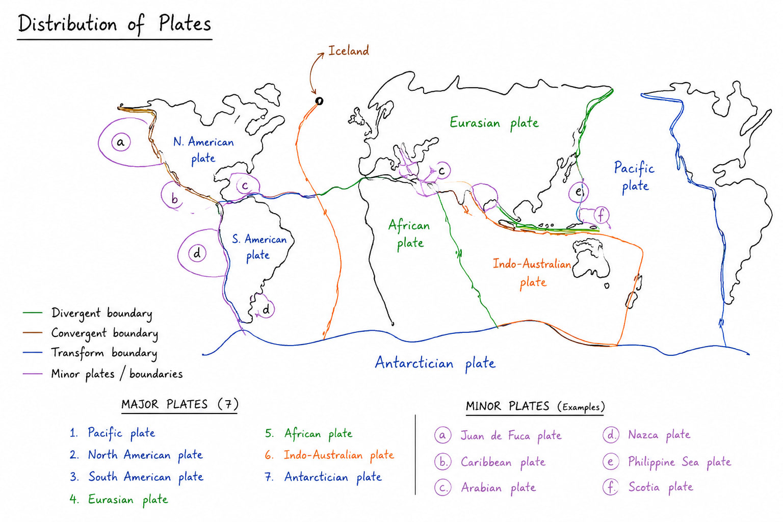
Plate tectonics is the theory which studies plates and various tectonic activities which take place along with plate margin. This theory was given in 1960s by Tuzo Wilson who quant the termed Plate, Dan Mackenzie, Woolrich Morgan, Arthur Holmes, Harry Hess. According to this theory, earth's outer rigid layer called lithosphere is broken into several large and small slabs which are called plates. These plates floats and move slowly over the semi molten layer beneath them called asthenosphere. Due to this plate movement several plate margin are formed along with the various tectonic activates like earthquake, volcanism, mountain buildings ocean trenches. mid oceanic ridings are formed.
Types of Plates
On the basis of their constituents
Continental Plate
Oceanic Plate
Oceanic cum Continental Plate
On the basis of their size
7 Major Plates are
North American Plate
South American Plate
African Plate
European Plate
Indo-Australian Plate
Antarctician Plate
Pacific Plate
20+ Minor Plate
Juan-de-fuca
Coscos Plate
Carrabin Plate
Nazca Plate
Scotian Plate
Somalian Plate
Arabian Plate
Turkish Plate
Barman Plate
Philippine Plate
Bismarck Plate
Distribution of Plates
Plate Margin
There are three types of plate margins
Constructive Plate Margin
It is formed when two plates move apart due to divergence. Two convectional currents operating beneath lithosphere in asthenosphere due to this
1. Fissure eruption of volcano occurs
2. Mid oceanic rigs are formed e.g. MOR of Atlantic
3. Earthquakes on mild magnitude occurs
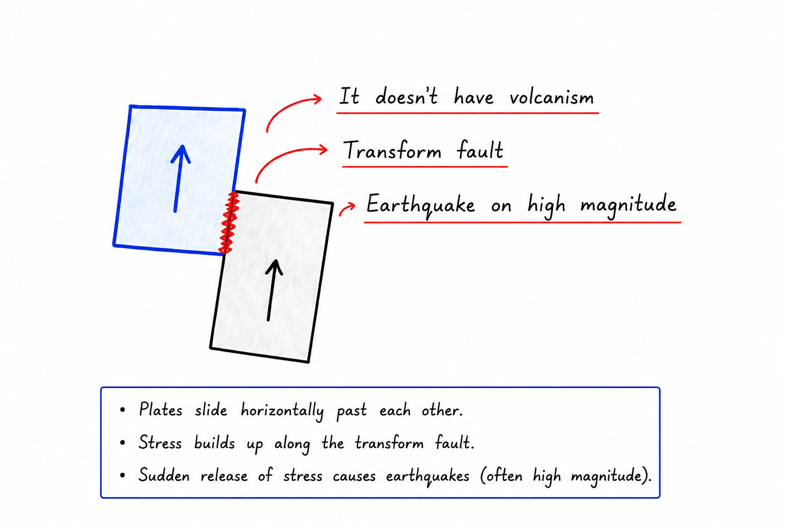
Conservative Plate Margin
Conservative plate margin are those one where two plates neither come close/ converge nor diverge/ move apart. Two plates simply slide pass to each other that's why there is construction or destruction either. It only develops
Transform faults
High Magnitude earthquakes
No volcanism
e.g. San Andras fault of North America.
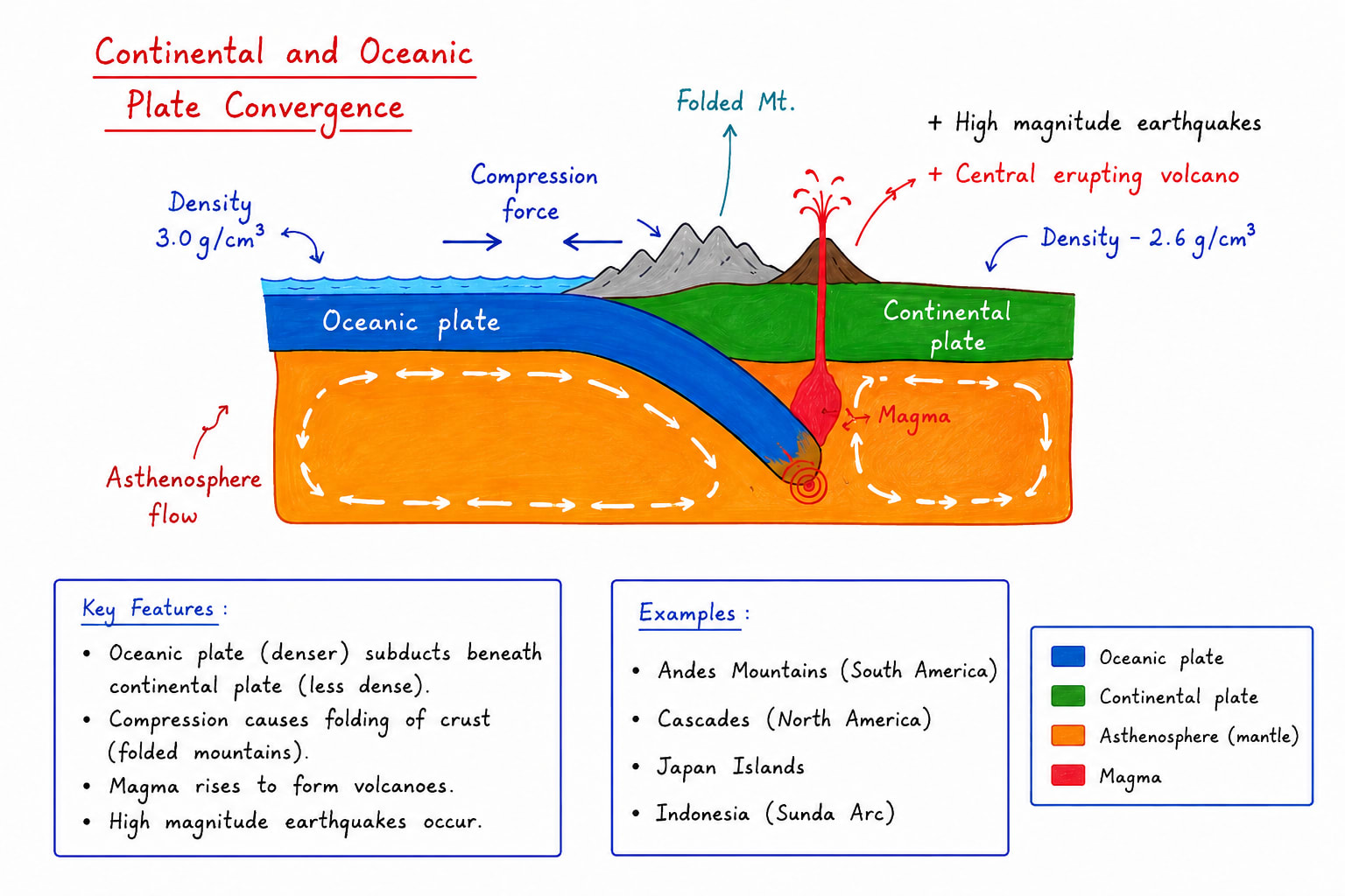
Destructive/Convergent Plate Margin
Destructive plate margin or convergent plate boundary develop when two plates move towards each other in this case three possibilities:-
Continental and Oceanic Plate Convergence
In this case
central eruption of volcano develops e.g. Mt. Stromboli of Italy.
folded mountains are formed e.g. Andes mountains were formed due to plate convergence between South American plate and Nazca plate.
high magnitude earthquake
Oceanic and Oceanic Plate Convergence
When two oceanic plate converge relatively heavier plate subducts under lighter plate due to this
Island arcs are formed and sometimes festoons also.
Central eruption of volcano e.g. Mt. Fuji of Japan, Mt. Mayon and Mt Tall Philippines, Mt. Krakatoa of Indonesia.
High Magnitude earthquakes and Tsunami e.g. 2004 tsunami was due Indonesia, 2011 tsunami was due to Japan
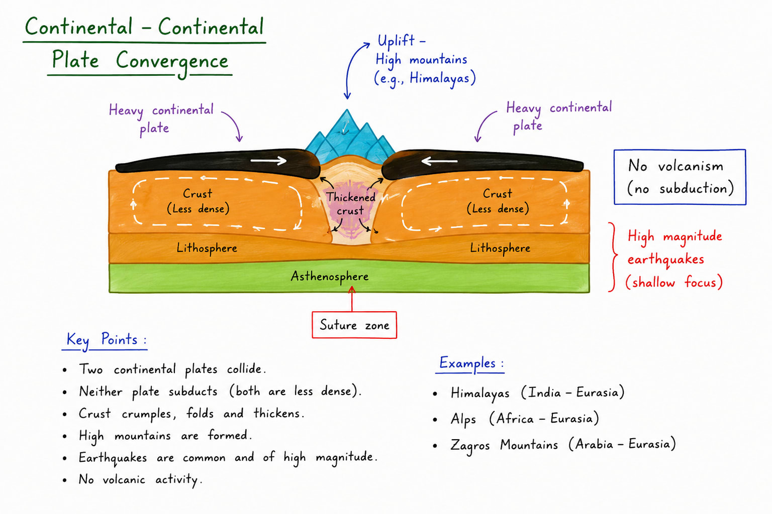
Continental and Continental Plate Convergence
When two continental plate convergence relatively heavier plate abducts beneath lighter plate due to this
High mountain ranges are formed. e.g. The Himalayas.
No volcanic eruption because
Thickness of the lithosphere become almost double due to abduction
Due to lack of water steam support to rising magma is very weak.
Rising magma is very vicious.
High Magnitude earthquake.
An island arc is Curved chain of volcanic island formed at a convergent plate boundary where one oceanic subducts beneath other oceanic plate. The subducted plate melts in the mantle magma rises through crack. repeated volcanic eruptions formed a chain of island parallel to the ocean trenches due to earth curvature and plate movement the chain generally develops a crescent or arc shape. e.g. Japan, Philippines, Indonesia, etc.Festoons is a highly curved chain like curvature arc it represent most pronounced form of island arc, resembling a garland or necklace. It is formed by intense subduction and strong compressional forces. The differential plate movement causes the arc to bend more sharply. These are often associated with deep ocean trenches and active volcano. Indonesia or Philippines are example of island arc and festoons.
Indonesia
Indonesia is located where several plates meet that Indo-Australian Plate, Eurasian plate, pacific plate and Philippines plate.
Formation Process of Indonesia
Stage 1- Subduction of Indo-Australian Plate: The oceanic part of the Indo-Australian plate move northward. It subducted beneath the Eurasian plateStage 2 - Formation of Ocean Trenches e.g. Java Trench and Sunda TrenchStage 3 - Magma generation: Subduction of plate in asthenosphere led to its melting and formation of magmaStage 4 - Development of Volcanic arc: Magma rose to the surface and formed Volcanic islands like Sumatra, Java, Bali, Lompoc, etc.
Indonesia is world largest archipelago. It has about 17000+ island, over 120 active volcanos and experiences frequent earthquakes and tsunami due to active subduction.
Formation Process of Philippines
Philippines lies at the junction of Philippine plate, Eurasian plate and Sunda plateStage 1 - Oceanic plate convergence: The Philippine sea plate and parts of the Eurasian plate moved toward each other. One heavier oceanic plate began subducting beneath the other.Stage 2 - Formation of deep Trenches: Subduction created deep ocean trenches such as Merina trench, Mindanao trench.Stage 3 - Magma Generation: The descending plate released water into mantle partial melting occurred. Magma rose through volcanos.Stage 4 - Volcanic Islands are formed: These islands merge and grew into larger islands such as Oleson.Philippines have move than 7000 island and numerous active volcanos.
Force responsible for plate Tectonics
According to geoscientist the most important force responsible for plate movement is flow of convectional currents which are operating in asthenosphere. These convectional currents are formed due to decay of radioactive elements which produces huge amount of heat and melts surrounding rock. These molten rocks form convectional current. when two convection cell converge or diverge overlaying plates converge or diverge respectively.
There are two secondary forces also responsible for plate movement:
Ritch push force: This force is applied by the magma rising through the divergent plate boundary
Slab Pull: When a subducting plate enters into asthenosphere it pulls rest of the plate inside.
Evidences of Plate Tectonics Theory
Evidences of Plate Tectonics Theory include:
Sea Floor spreading
Palaeomagnetism
Hot spots (Volcanos)
Sea Floor Spreading and it's support to Plate Tectonics Theory
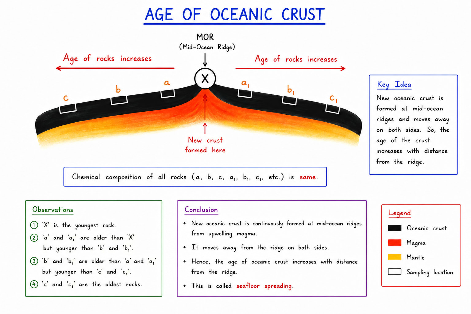
The idea of sea floor spreading refers to the process by which new oceanic crust formed at mid oceanic ridges and gradually moves away on either side. The concept was proposed by Harry Hass in 1960s and became a crucial foundation for the theory of plate tectonics.
According to this theory, molten magma rises from the mantle through fissures at divergent plate boundaries, specially along mid oceanic ridges such as mid Atlantic ridge. As the magma cools and solidifies, it forms new basaltic crust. Continuous addition of new material pushes the older crust away from the ridge, causing the ocean floor to spread.
Mechanism of sea floor spreading
Upwelling of magma occurs due to convection currents in the mantle.
New oceanic crust is created at the mid oceanic ridge.
Older crust moves outward symmetrically.
Oceanic curst is eventually destroyed at subduction zone or ocean trenches.
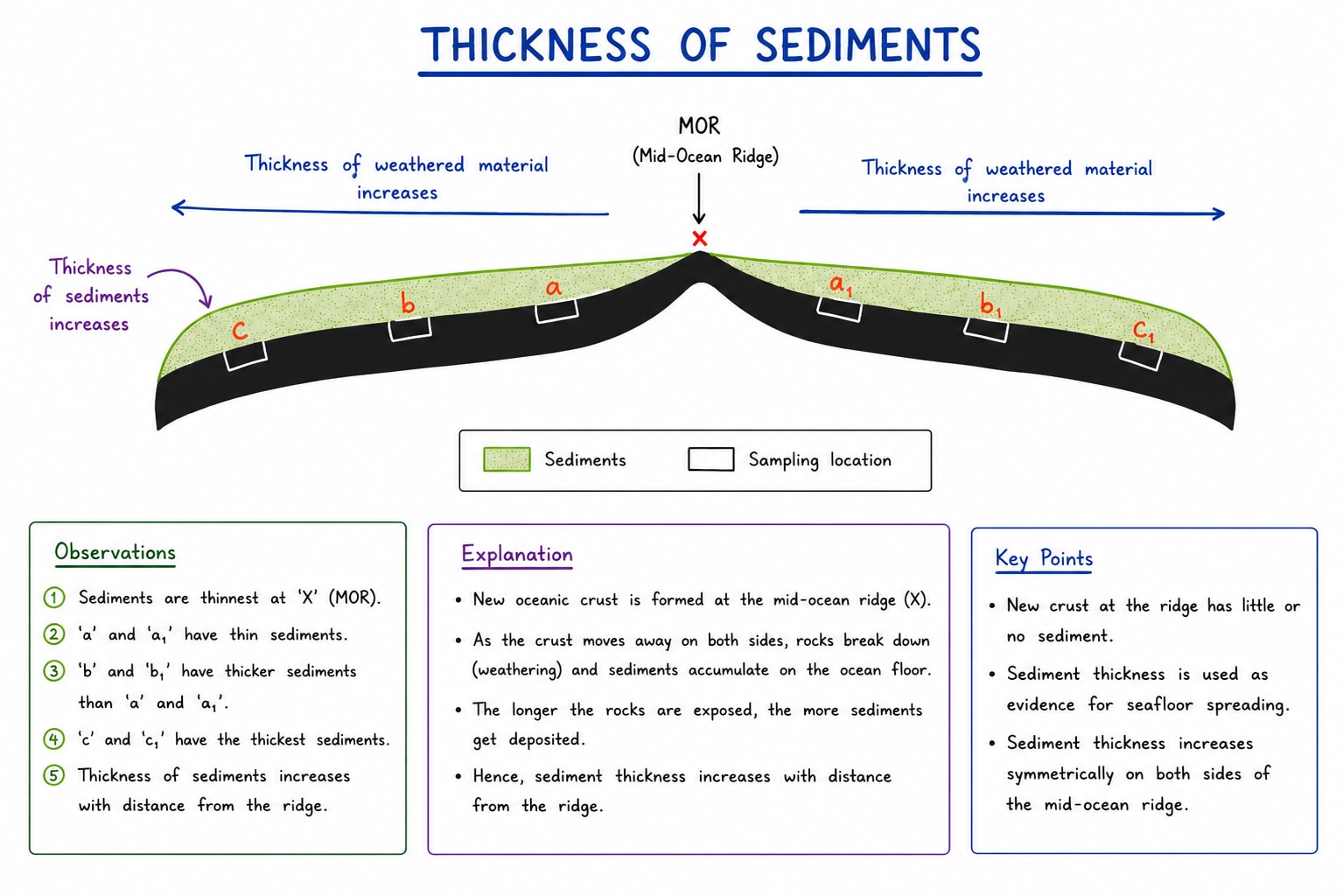
Evidences supporting Sea floor Spreading.
Age of Oceanic Crust:- Rocks near the mid-oceanic ridges are younger while those farther away are older.
It clearly suggest that gradual spreading of the sea floor is a reality.
Thickness of Sediments:- Marnie sediments are thinner near mid-oceanic ridge and thicker away from them because older crust has had more time to accumulate sediments.
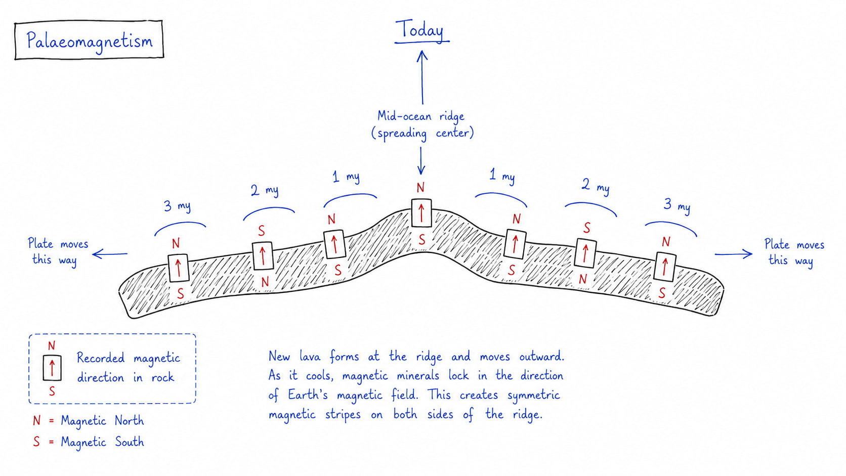
Palaeomagnetism:- Alternating magnetic bands on either sides of ocean ridges record periodic reversal in earth's magnetic field. The symmetrical arrangement proves continues creation and outward movement of oceanic crust.
Sea floor spreading provided the physical mechanism for continental drift proposed by Wegener. It demonstrated that lithosphere are not stationary but move continuously over the asthenosphere. The creation of crust at divergent boundaries explain the continental movement, plate movement, mountain building, earthquake, ocean trench formation and volcanism.
Palaeomagnetism
Palaeomagnetism refers to the study of the record of earth's ancient magnetic field preserved in the rocks. When volcanic rock solidify magnetic materials such as magnetic align themselves according to the direction of earth's magnetic field at that time. These magnetic signatures remain locked within the rocks and provide valuable evidence about past movements of continents and ocean floor.
The concept of Palaeomagnetism became a major breakthrough in validating the theory of plate tectonics during the mid 20th Century.
Process of Palaeomagnetism
Earth behaves like a giant magnet with north and south magnetic poles.
Molten rocks containing magnetic minerals align with earth's magnetic fields during cooling.
Once solidifies after getting magnetic polarity, magnetic orientation is preserved permanent. It does not change unless the rock is exposed to higher temperature beyond 600oC (Curie Point).
Over geological time reversal in earth's magnetic field create distinct magnetic patterns in rocks.
Evidences from Palaeomagnetism
Magnetic Reversal:- Geological studies revelled alternating bands of normal and reversed polarity on the ocean floor. These magnetic strips occurs symmetrically on both side of mid oceanic ridges providing continuous formation of outward movement of oceanic crust.
Age and Magnetic Patter corelation:- The age of rocks increases with distance from mid-oceanic ridges while magnetic patterns remains symmetrical. These confirms sea floor spreading and movement of plates.
Evidence of Continental movement:- Palaeomagnetic data showed that continents such as south America and Africa were once joint and later drifted apart.
Role in supporting Plate Tectonic Theory
Palaeomagnetism provide strong quantitative evidence for both continental drift and sea floor spreading. It demonstrated that lithospheric plate move over time and that oceanic crust is continuously created and displaced.
The discovery of symmetrical magnetic strips around mid-Atlantic ridge become one of the strongest proofs of plate tectonics. It also explained the dynamic nature of earth's crust including earthquake, volcanism, and mountain building.
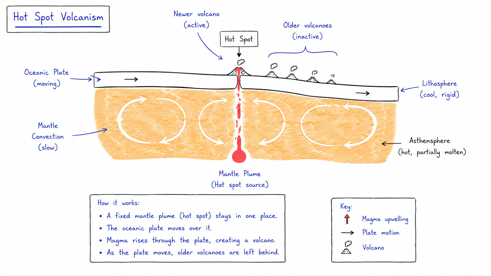
Hot spots and their role in supporting plate tectonics
Hot spots are localized zone of intense volcanic activity caused by rising plumes of hot magma from deep within core-mantle boundary and this is called mantle plume.
Unlike ordinary volcanos formed at plate boundaries, hot spots may occur in the interior of tectonic plate. This concept was explained by Tuzo Willison and became important evidence for plate tectonics.
A hot spot remains relatively stationary while tectonic plate move over it. As the plate shifts successive volcanos are formed, creating chains of volcanic island and sea mounts (Volcanic mountains formed under water).
Mechanism for hot spot activity
The mantle flume rises from deep inside earth due to high temperature and low density.
Magma reaches the surface through weak zones in the lithosphere.
Volcanic eruptions create island or volcanic mountains.
As the tectonic plate moves, older volcanos become inactive and new volcanos formed above the hot spots.
Evidences from hot spots
Volcanic island chains:- Chains of volcanic island show a clear age progression. The youngest volcano lies above the active hot spot, while older volcanos are farther away.
Direction and speed of plate movement:- The orientation and age of volcanic chains helps scientist determine the direction and rate of tectonic plate movement.
Evidence independent of plate boundary:- Hot spots occur even within the plates proving the plate themselves are moving rather than volcanic zone shifting.
Good example of hot spot are Hawaii hot spot of Pacific, Reunion hot spot of Indian Ocean, Icelandic hot spot of Atlantic ocean, Yellow stone park hot spot of US.
Earthquakes
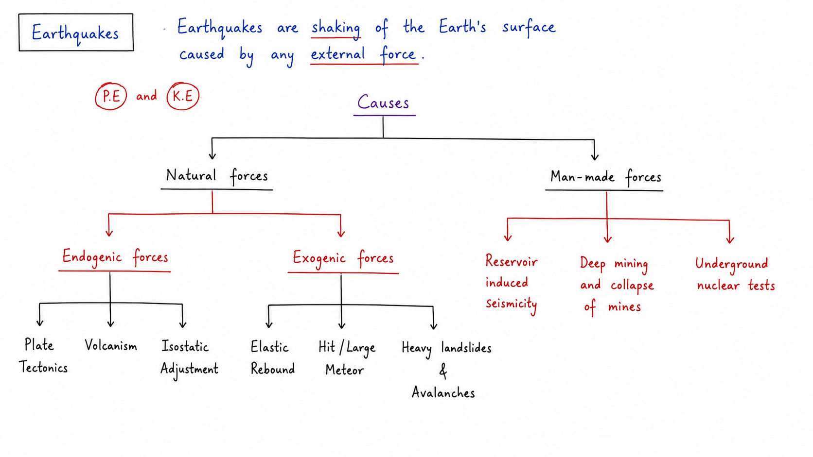
Earthquakes which are deep shaking in the earth surface are basically caused when a massive exogenic force converts huge amount of potential energy to kinetic energy. This energy flows in the form of seismic waves through the medium of earth surface and cause deep shaking.
Causes of Earthquakes
Tectonic Movement:- The Earth's lithosphere is divided into several tectonic plates that are constantly moving due to convection currents within the mantle. These movements occur at convergent (destructive), divergent (constructive), and transform (conservative) plate boundaries. As plates interact, enormous stress accumulates in rocks along faults and plate margins. When this stress exceeds the strength of the rocks, they suddenly break or slip, releasing energy in the form of seismic waves and causing an earthquake. Tectonic movements are responsible for the majority of earthquakes worldwide, particularly around the Pacific Ring of Fire, the Himalayan region, and major fault systems such as the San Andreas Fault.
Volcanism:- Volcanic activity can generate earthquakes due to the movement of magma beneath the Earth's surface. As magma rises through cracks and fissures, it exerts pressure on the surrounding rocks, causing them to fracture and produce seismic tremors. Explosive volcanic eruptions may also trigger earthquakes by the sudden release of gases and magma. These earthquakes are generally localized around volcanic regions and are often known as volcanic earthquakes. They commonly occur near active volcanoes such as Mount Etna, Mount St. Helens, and Kilauea.
Isostatic Adjustment:- The earth's crust sometimes rises or sinks to maintain balance after nature changes in the weight on the surface e.g. when glaciers melt after an ice age, the enormous pressure on the crust decrease. The crust slowly rises upward, causing a stress within the rock. This process is called isostatic adjustment. The release of this stress may produce earthquake e.g. Greenland is experiencing earthquake very frequently due to melting of the glaciers which is caused by global warming.
Elastic Rebound:- Earth crust stores huge amount of energy. The sudden release of stored energy causes earthquake. Actually earth crust is made of several layers and this is part of the plate. Tectonic forces continuously exert stress on rocks along fault lines, destructive plate, constructive plate and conservative plate margin. These rocks deform elastically and store strain energy over time. When the accumulated stress exceeds the strength of the rock they suddenly fracture or slip along the fault. The stored energy is then released in the form of seismic waves, causing an earthquake. After the rupture the rock rebound to less deformed state. Actually this is the factor responsible for most of the earthquake which occur along with fault lines worldwide.
Heavy landslide or Avalanche:- Large land slides or avalanche also trigger earthquake when a huge mass of rock or ice suddenly moves down mountain slope due to gravity they create deep shaking in the earth surface. It is very important cause of earthquake in hilly areas specially. e.g. Uttarkashi, Chamoli, Pithoragarh district of Uttarakhand.
Meteoritic Hit:- Sometimes meteors of extra-ordinary large size hits earth surface e.g. a meteor hit earth near Mexico about 65 million years ago, it causes supermassive earthquake, supermassive tsunami led to the extinction of dinosaurs.
Mining Activities:- Mining operation involves drilling, blasting and removing large quantities of rocks and minerals beneath earth surface. These activities weaken underground rock structure and disturb natural balance of pressure withing the crust. Sudden collapses or explosions inside mines can produce deep shaking and small earthquakes. Many mining regions on India like Bastar plateau, Chhota Nagpur plateau, Karnataka plateau keep on experiencing minor earthquakes.
Reservoir Induced Seismicity:- The construction of huge dams creates artificial reservoir containing massive amount of water. The weight to this store water exert pressure on the earth crust below. Water can also seep into cracks in rocks, reducing friction and increasing the possibility of movement along faults. This phenomenon is called reservoir induced seismicity. Several earthquake around the world have been large dam projects. e.g. Koyna dam in Maharashtra. (Koyna is tributary of Krishna)
Nuclear explosion:- Underground nuclear test release enormous amount of energy in a very short time, this energy create minor earthquakes.
Types of Earthquake Waves
Seismic waves are the waves of energy produced during an earthquake these waves travel through the earth and along its surface causing the shaking felt during earthquakes. Scientist study seismic waves to understand the structure of earth and to major the strength and location of earthquake. Seismic waves are mainly divided into two broad categories
Body Waves:- It originates from focus and moves thorough the inner layers of earth. They are faster than surface waves. These are of two types
Primary Waves:- P waves are called primary waves because they travel the fastest and arrived first at seismic station after an earthquake occurs. It has following properties.
It carries maximum energy.
It has shortest wavelength.
It has maximum speed.
It travel through solid, liquid and gaseous medium.
It is longitudinal wave because it causes particles of the medium to vibrate parallel to direction of propagation.
S Wave:- S waves are called secondary waves because they arrive after p waves.
These wave move in side to side or up or down motion i.e. perpendicular to the direction of propagation.
Its wavelength is longer and velocity is slower than p wave.
It can only travel through solid medium.
It produces stronger shaking than the p wave.
It is a transverse wave.
Surface Wave:- Surface wave originates from epicentre. Epicentre is a point on the surface which is nearest to focus. Types of surface wave
Love Wave:- Love waves moves the ground horizontally from side to side. They do not create vertical movement. It travel faster than Rayleigh waves. It is name after British Mathematician AEH Love. It is also a transverse wave.
Rayleigh Wave:- Rayleigh waves move like a wave originating in water if a pebble is thrown into it that's why these have rolling and circular motion. These have slowest speed and responsible for most severe damage.
Measurement of Seismic Waves
Mercalli Scale
Mercalli intensity scale measure the intensity and effects of earthquake on people, buildings and earth's surface. It was developed by Giuseppe Mercalli. This scale used roman numerals form I to XII.
Properties of Mercalli Scale
It measures earthquake intensity and damage.
It is based on observation and effects.
It uses roman numerals from I to XII
It varies from place to place for same earthquake, depends on population density and efficiency of disaster management.
Useful for understanding earthquake impact on society.
The meaning of I on this scale is not felt except by instruments, where XII means extreme destruction.
Richter Scale
Richter scale was developed in 1935 by CF Richter. He was from California, USA. It measures the magnitude or energy released by an earthquake. The scale is logarithmic, meaning each whole number increase represents a 10 fold increase in amplitude and about 31.5 times more energy released.
Properties of Richter Scale
The Richter scale is based on amplitude of seismic waves recorded by a seismograph.
It is widely used for measuring small and medium earthquake.
It is logarithmic in nature. With every increase in number it causes much stronger difference between the 2 numbers is 31.5 times in terms of energy and 10 fold increased in amplitude.
Meaning of 1 on Richter scale is the energy equivalent to the energy released by explosion of 1 kg of TNT (Trinitrotoluene) a kind of explosive. The difference between 1 and 2 is 31.5 times, difference between 1 and 3 is 31.52 and 1 and 10 is 31.59 times.
This scale is ranges from 1 to 10 but its upper limit is not fixed it could be extended.
Any earthquake occurring less than 3.5 on Richter scale is usually not felt by humans but felt by animals (specially reptiles).
Any earthquake occurring 5.5. to 6 on Richter scale is less damaging.
Earthquake occurring 6.1 onwards can be destructive. 8.0 and above are severally destructive.
Richter scale is most frequently and widely used scale because of its scientific conclusion and high objectivity.
Moment Magnitude Scale
The moment magnitude scale is the modern scientific scale used to measure earthquake accurately if comes on super high magnitude. It was developed to overcome limitations of the Richter scale specially for very large earthquake. This scale measured the total energy released by an earthquake based on fault moment, rock strength and the area affected.
Properties of Moment Magnitude Scale
It measure total energy released.
More accurate for large earthquakes, use worldwide by modern scientist.
It is based on seismic movement calculation.
Does not saturate for powerful earthquakes.
Provide consistent global comparisons.
Instrument used to measure Seismic Waves
Seismograph
A seismograph is an instrument that detects and records seismic waves during an earthquake. It consist of the recording device.
Seismometer
A seismometer is a sensitive scientific instrument to measure ground motion accurately.
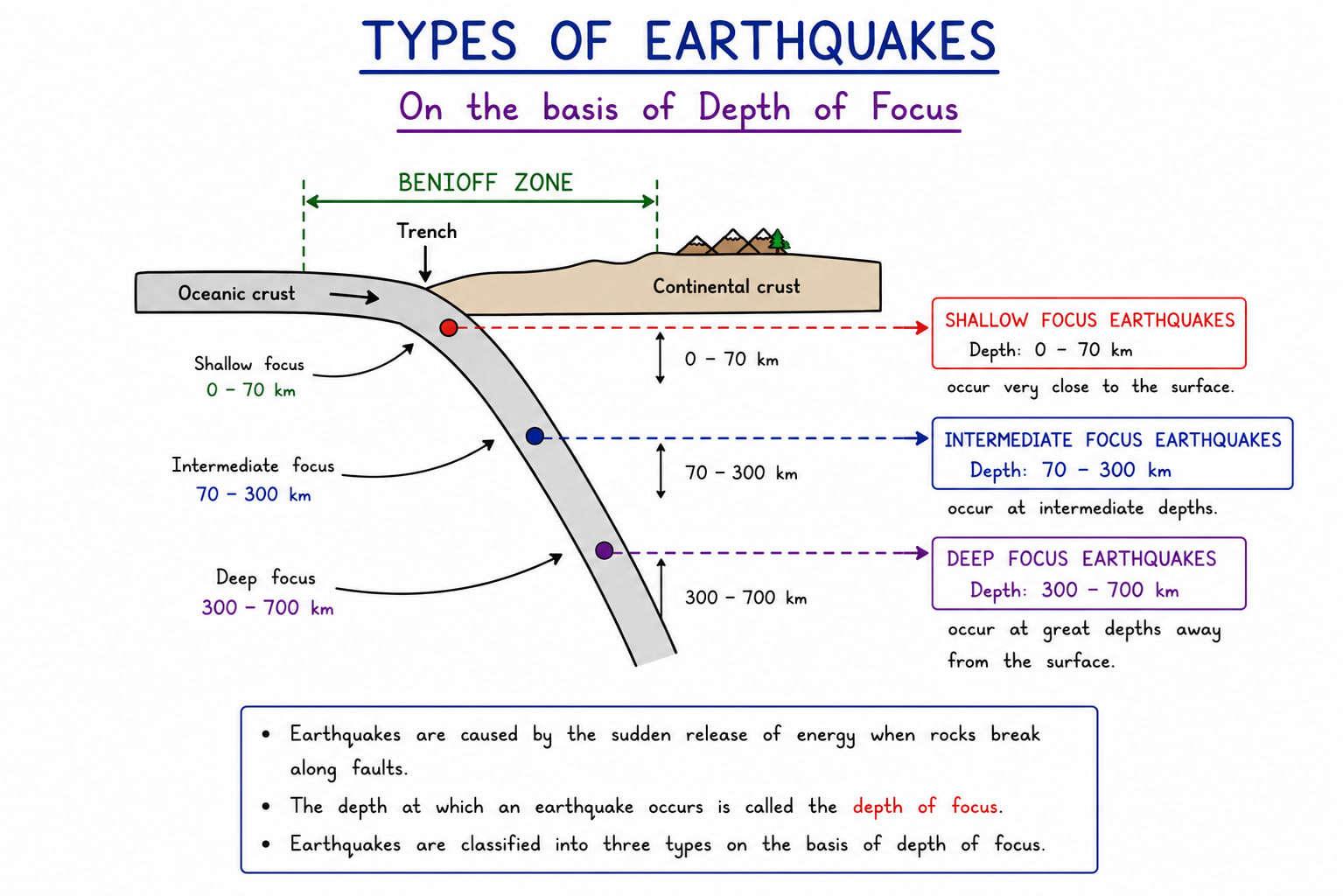
Types of earthquake on the basis of depth of focus
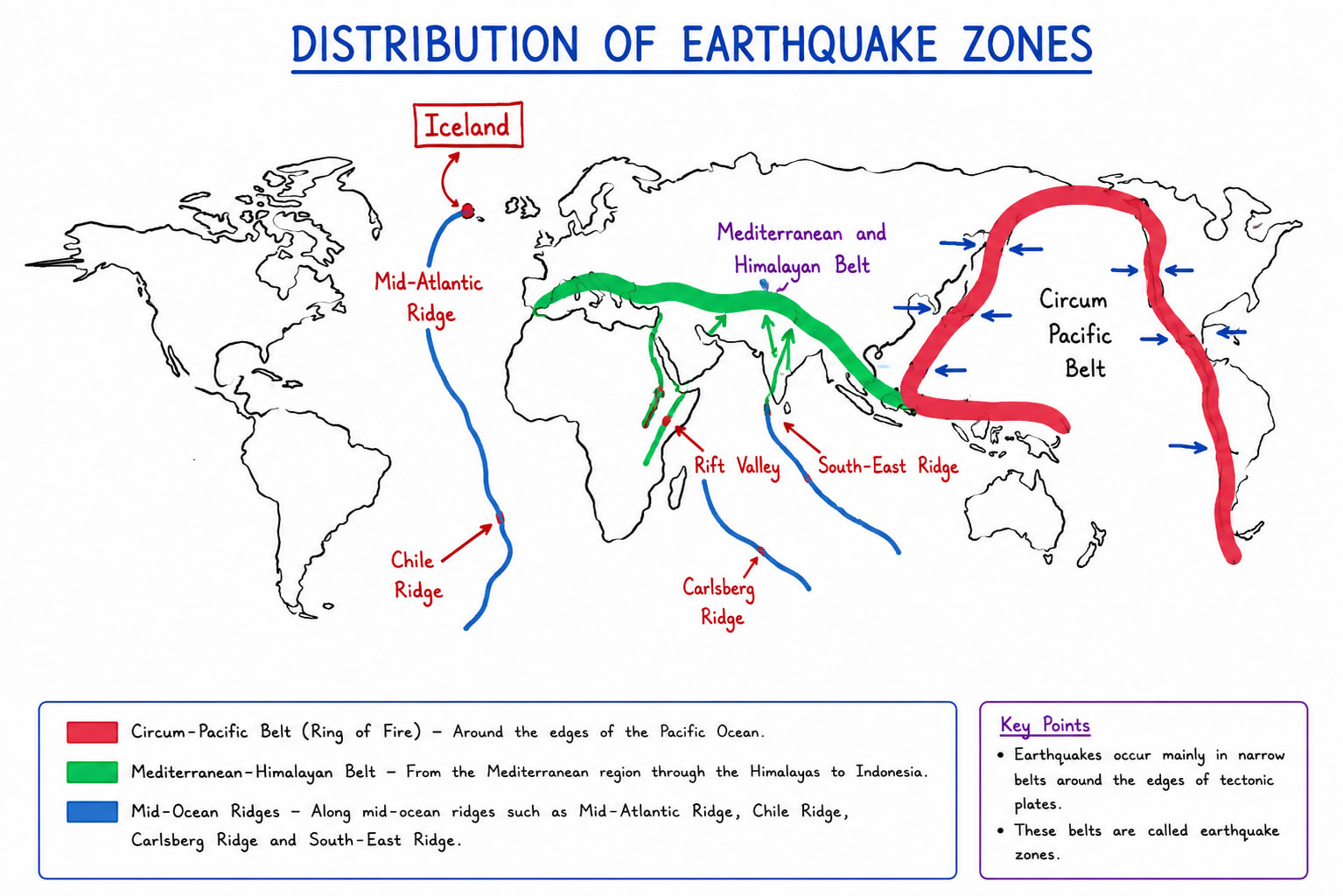
Distribution of Earthquake
Circum Pacific Belt
Circum Pacific Belt which is also called Pacific ring of fire is the largest and most active earthquake zone in the world. It surrounds the Pacific ocean and contains about 75% of the worlds active volcano and nearly 80% of major earthquakes. This belt passes through the western coast of North and South America, eastern coast of Asia and Oceania. Countries such as Japan, Indonesia, Chile, US, Ecuador experience frequent earthquakes.
Mediterranean-Himalayan Belt
This earthquake belt extends from the Mediterranean region through middle east and Himalayan region into south-east Asia. It is second largest seismic belt in the world. Earthquake in this region occur mainly because of African plate and Indian plate collide with Eurasian plate.
Mid-Oceanic Ridge Belt
It lies underwater in Atlantic ocean and Indian ocean mainly. Mid-Oceanic ridges are fought along with divergent plate boundaries. Earthquakes in this belt are usually less destructive.
However since earthquakes are not only caused by endogenic forces only these are caused by exogenic forces as well as man made forces. That is why earthquake can occur anytime, anywhere. No place in the world is earthquake proof.
Seismic Map of India
Seismic map of India is a map that shows the earthquake prone regions of the country according to expected intensity and frequency of earthquake. It helps to identify areas that are more vulnerable to seismic activity so that the proper safety measures and construction standard can be followed. The seismic zoning of India is very important because the country lies near active tectonic plate boundary, specially the collision zone between the Indian plate and the Eurasian plate.
The Seismic zones of map of India is prepared by the Bureau of Indian Standards. The map is included in Indian Standard Code i.e. IS 1893- Criteria for earthquake resistance design of structures.
The Bureau of Indian Standards updates the map from time to time based on:
New geological studies
Historical earthquake records
Seismological research
Tectonic movements
Scientific observations of seismic activities
The National Centre of Seismology and other scientific organization also provide important seismic data in preparing and revising these maps.
Objective of Seismic Map
Identification of earthquake prone areas.
Safe construction practices.
Disaster management and planning.
Urban and Regional Planning.
Public Awareness and Safety.
Criteria Used for Seismic Zoning of India
Frequency of earthquakes.
Magnitude and intensity of earthquake.
Tectonic and geological conditions.
Nature of soil and rock structure.
Seismological studies by using modern instruments like satellite based observations and seismograph.
Historical damage records.
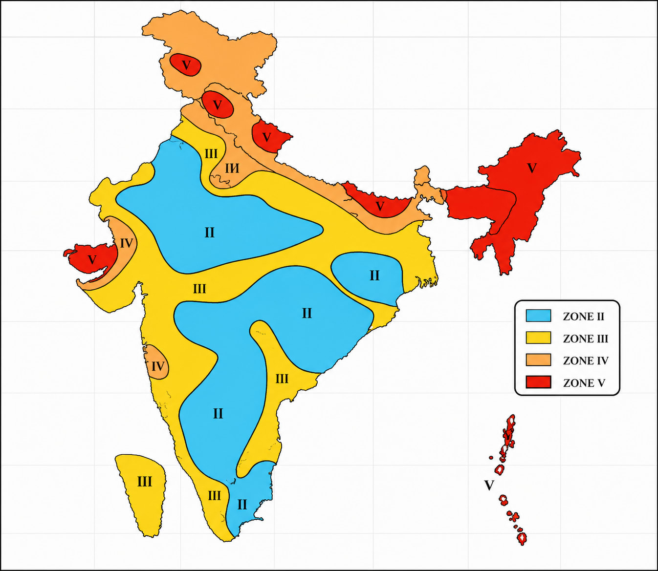
Seismic Zones of India
India is divided into four seismic zones based on earthquake hazard levels. Earlier there were five zones but zone I was removed after revision done by BIS. The present seismic zones are
Zone II It is low damage risk zone. It includes Karnataka, Tamil Naidu, Madhya Pradesh, parts of Rajasthan
Zone III Moderate risk zone. It includes Keralam, West Bengal, Maharashtra.
Zone IV High damage risk zone. It includes Delhi, Bihar, Punjab, Himachal Pradesh, Uttarakhand, south-western Maharashtra and parts of Gujrat.
Zone V Very high damage risk zone. It includes Jammu and Kashmir, Andaman and Nicobar and western Gujrat.
Some Important Terms
After Shock
It is small earthquake occurring after main earthquake. This is very dangerous.
Foreshock
Small shock before occurring before main earthquake.
Liquefaction
It occurs when water saturated loose soil temporarily behave like liquid during strong earthquake causing building to sink.
Seismic Gap
It is section of end active fault that has not experienced earthquake for a long period.
Isoseismal line
A line drawn on the paper to connect places which experience equal earthquake intensity
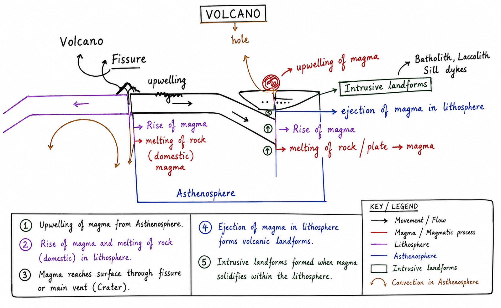
Volcanism
Volcanism is a dynamic process which includes:-
Melting of rocks and magma formation in asthenosphere.
Rises of Magma
Ejection of magma into lithosphere/ Crust.
Upwelling of magma on the surface.
Types of material which comes out during volcanic eruptions
Water Vapour:- water vapour constitutes about 70% to 80% of the total material which comes out during volcanic eruptions.
Different Gases:- which includes carbon dioxide, sulphur dioxide, hydrogen sulphides, nitrogen.
Volcanic eruption is most important natural source to contribute in sulphur dioxide in the atmosphere.
Lava:- Lava means molten rock. Molten rock beneath the surface called magma, when it reaches the surface it is called lava.
Pyroclastic Material:- Pyroclastic material are those one which are part of the surface which has been broken and flowing with lava.
Types of Volcanic eruptions
On the basis of eruption process these are categorized into two:
Central Eruption of Volcano:- It is called central eruption when magma upwells on the surface through a hole or vent. These are associated with destructive plate margin i.e. convergent plate margin when one oceanic plate converges with other oceanic and continental plate. The features of central eruption of volcano are:-
Magma erupts with burst.
The lava is highly viscous.
On pH scale lava is acidic.
Eruption process is highly explosive. On the basis of explosion intensity these are further categories into
Hawaiian Type:- It is most gentle type of eruption.
Strombolian Type:- It has moderate explosive activity.
Vulcanian Type:- It is violent explosion.
Pelean Type:- It is extremely violent explosion.
Plinian Type:- It is most explosive type.
Fissure Eruption of Volcano:- When lava erupts thorough long crack or fissure instead of central vent it is called fissure eruption. These eruptions spread lava over a wide area. Properties of fissure eruption includes:-
These are associated divergent plate boundaries.
Lava is least viscous.
On pH scale lava is basic.
On the basis of age or state. These are categories into three
Active Volcano:- A volcano that erupts frequently or shows signs of activity is called active volcano. Other definition is that any volcano which has erupted during Holocene are called active volcanos. Good e.g. include
Barren Island, Andaman and Nicobar. Only active volcano of India which lies 130km east of Andaman and it is process of eruption since 1990s
Mt. Stromboli, Italy. It is called light house of Mediterranean sea
Ojas-del-saldo, South America. One of the highest active volcano in the world.
Dormant Volcano:- A volcano that has not erupted for a long time but may erupt in future is called dormant volcano. e.g. Mt. Fuji, Japan, Mt. Kilimanjaro, Kenya Africa.
Extinct Volcano:- A volcano that has not erupted in historical times and is not expected to erupt again is called an extinct volcano. e.g. Mt. Kenya, Arthur's Seat
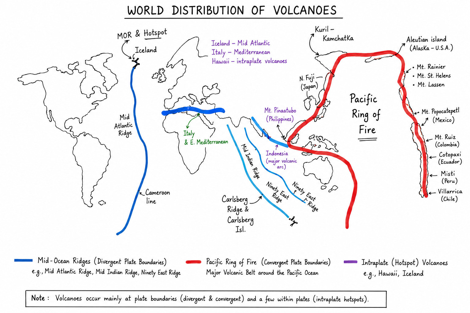
World distribution of Volcanos
Volcanos are unevenly distributed on earths surface most volcanos are found along plate boundaries where tectonic plates interact their distribution is closely related to zones of earthquake and mountain, island arc building.
Major Volcanic Belts of the world
Volcanos are mainly concentrated in three major belts:
Circum Pacific Belt
It is also called ring of fire. This is the largest volcanic belt of the world surrounding the pacific ocean. About 75% of the worlds active volcanos are found here. e.g. Mt. Fuji of Japan, Kamchatka of Russia, Aleutian Volcanos of USA Alaska, Mt. Hood of US, MT. Rainier US, Mt. Sasta US, Mt Cotopaxi of South America, Mt Chiambarjo of South America, Mt Ojas Dal Salado South America
Volcanic eruption of 2026 in Pacific Ring of Fire
Axial Sea Mount - Oregon coast USA
Volcan - Oregon coast USA
Volcan-de-Fuego - Guatemala, a Central American Country
Bismarck Sea Eruption - Papua New Gini
Mid World Mountain Belt
It is also called Mediterranean Asian Belt. This belt extends from Mediterranean region eastward through Asia. It is second major volcanic belt. It includes Mt. Etna, Mt. Vesuvius, Mt. Stromboli which is called light house of Mediterranean. It extends in Asia, in Myanmar Mt. Popa in Andaman Nicobar Bearn Island, in Indonesia Mt. Cracktoa and finally merges in Pacific ring of Fire.
Volcanic eruption of 2026
In 2026 Mt. Etna and Mt. Stromboli are erupting, Bearn Island are erupting since 1990s.
A part of Mediterranean belt extends southward in Africa and goes up to Kenya where Kilimanjaro is situated.
Mid Oceanic Ridge Belt
This volcanic belt is found in along with divergent plate boundaries in Atlantic Indian and Pacific Ocean. In Atlantic ocean it is called Dolphin ridge volcanic eruption. In Northern Atlantic Iceland has active volcano. It is situated upon mid oceanic ridge as well as hotspot volcano. MOR of southern Atlantic is called challenger ridge.
In Indian Ocean good e.g. are Carlberg ridge, Lakh Debi Chegoes Ridge, 90 east ridge, etc. In Pacific Ocean Nazka Rige
Hotspot Volcanos
These are special type of volcanos which occur away from plate boundaries. It receives magma from core mantle boundary, from their it reaches to surface as mantle plume. Good example of hotspot volcano are Hawaii Hotspot in Pacific, Reunion hotspot in Indian Ocean, Icelandic hotspot in Atlantic Ocean, Yellow stone Volcano in North America.
Landforms formed by Volcanic Activities
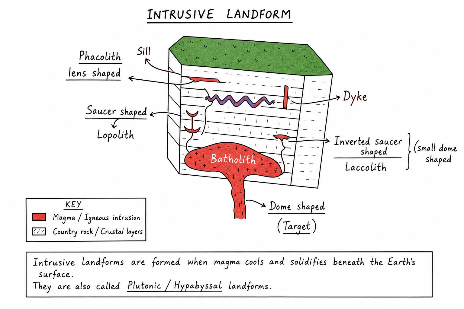
Intrusive Landform:- Intrusive landform are formed when magma cools and solidifies below the earth surface before reaching on the surface. These landform are also called plutonic landforms because the cooling occurs slowly underground, intrusive rocks usually have large crystals. These are made up of granite mostly.
instusive_landforms
Major intrusive landforms are
Batholith are mass of intrusive rock formed deep inside the crust e.g. Ranchi Batholith
Laccolith are dome shaped intrusive body looks like mushroom e.g. Henry Mountains
Lopolith are saucer shaped intrusive landform e.g. Bushveld Igneous Complex.
Phacolith are lens shaped intrusive landform. It occurs in anticlines and synclines of the rocks.
Sill are horizontal layer of magma.
Dyke are vertical layer of magma/ igneous rock.
Extrusive Landforms:- In central eruption of volcano magma comes out through a hole which is called mouth. and in fissure eruption of volcano it comes through a deep crack i.e. called fissure.
Crater is large mouth
Caldera is a very very large mouth which is formed through implosion.
Nested Caldera is formed when large caldera is filled with small mouth or cone, formed due to small eruption of successive volcanic activity. It seems like a large nest of bird is filled with eggs.
Crater like if formed when creator or caldera of extinct volcano is filled with rainwater or flood water.
Miscellaneous Terms
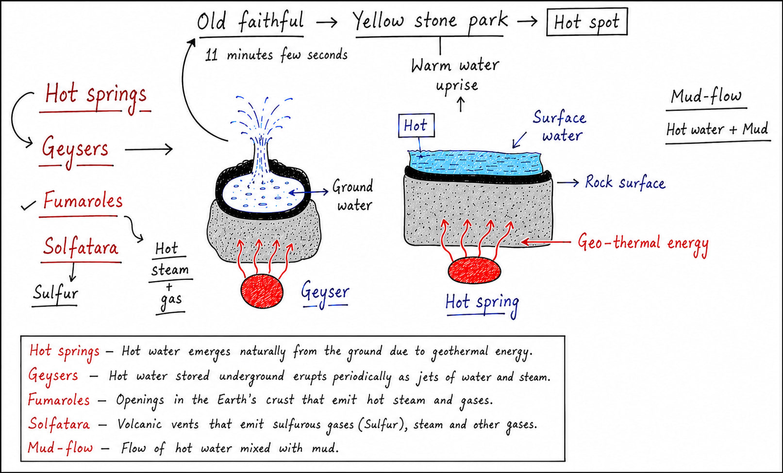
Hot springs, geysers, fumarole, solfatara are known as secondary volcanic features because they are produced by volcanic heat after the volcanic activity declines.
Hot Spring
A hot spring is a natural spring in which surface water is heated by volcanic or geothermal heat and emerges at the earth surface as warm or hot water.
Formation of Hot Spring
The surface water present in the lake, pond or running water is heated up by the geothermal energy present just beneath the surface. The temperature of water is higher than normal surface water. It is very rich in minerals. Good e.g. are Manikaran Sahib Himachal Pradesh, Puga Valley Ladakh, Rajgir Bihar.
Geyser
A geyser is a ejection of hot water when the groundwater is heated up by the geothermal beyond certain temperature, then the hot water and stream are forced upward through narrow openings. Geysers are the points of periodic eruption and it requires intense geothermal heat. The best e.g. is Old Faithful of Yellowstone National Park in Wyoming state of USA.
Fumarole
A fumarole is an opening in the earth crust through which steam and volcanic gases escape. These gases mainly include water vapour, sulfur dioxide, hydrogen sulphide, and carbon dioxide. Good e.g. is Valley of Ten Thousand Smokes in Alaska.
Solfatara
Solfatara is special type of fumarole or hot spring which emit large quantity of sulfur dioxide.
Mud Volcano
Mud Volcano are cone shape features that erupts hot mud gases, water instead of magma/lava. It is mainly associated with regions which have gas and petroleum.
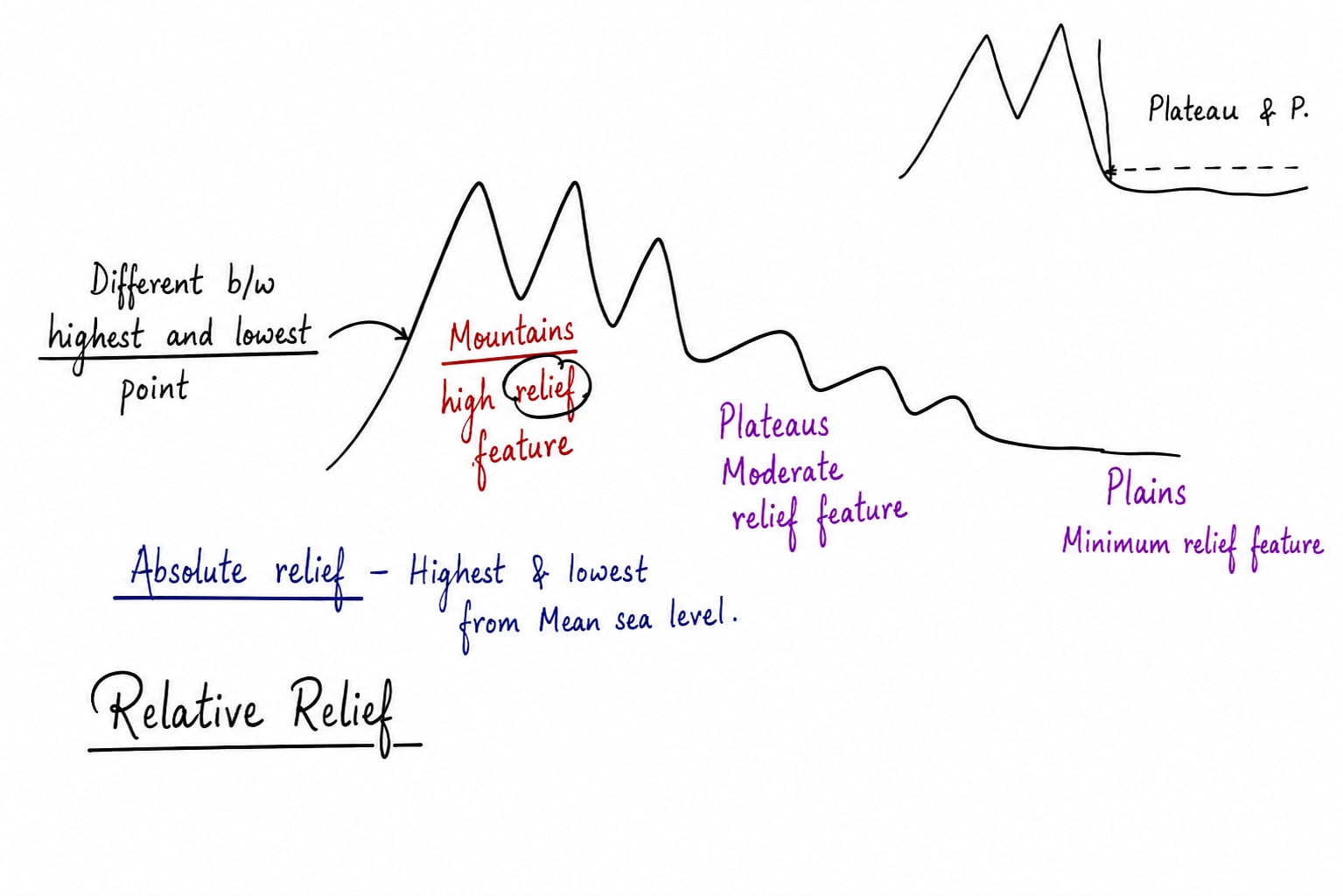
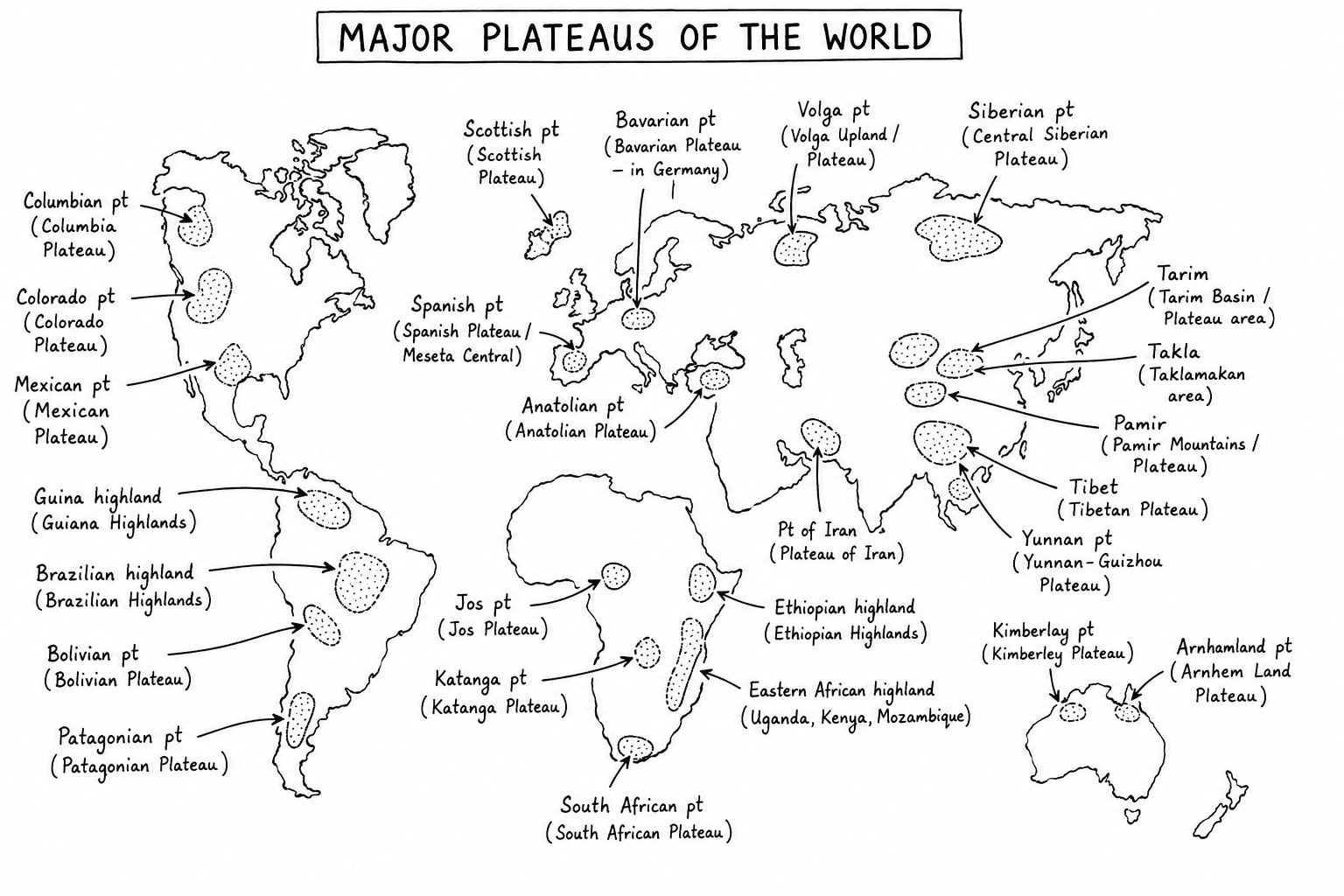
Mountains, Plateaus and Plains
Types of Landforms
Primary Landform:- Continents and Ocean Basins
Secondary Landform:- which are formed upon continents and ocean basins like mountains, plateau and plains
Tertiary Landform:- which are formed upon mountains, plateau and plains like river deltas, beaches, etc.
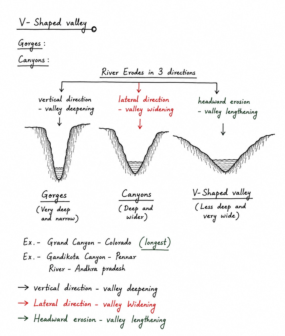
Mountains
Mountains are most important feature of earth surface in terms of their size, process of formation, etc. On the basis of their origin mountains are categorized into four types.
Folded Mountains
Folded Mountains are formed mainly by the compressional forces when tectonic plate move toward each other. e.g. The Himalayas, Alps, Andes, etc.
Process of formation of Folded Mountains according to plate tectonics
Deposition of Geosyncline:- Geosyncline is a long narrow subsiding basin where these layers of sediments accumulate over millions of years. Rivers and winds bring sediments into to basin gradually sediments became every thin due to continues deposition.
Movement of Plates:- According to the plate tectonics theory, the earth crust/ lithosphere is divided into plates that move slowly when two plates converge strong compressional force develops and sedimentary layers of geosyncline are squeezed.
Folding of Sedimentary Rocks:- Due to compression rocks layers bend into folds and gradually these folds develop into folded mountains.
Good e.g. of this process is The Himalayas which was formed due to compressional forces applied by Eurasian plate and Indo-Australian plate upon Tethys geosyncline which was present between these two plates.
Types of Folded Mountains
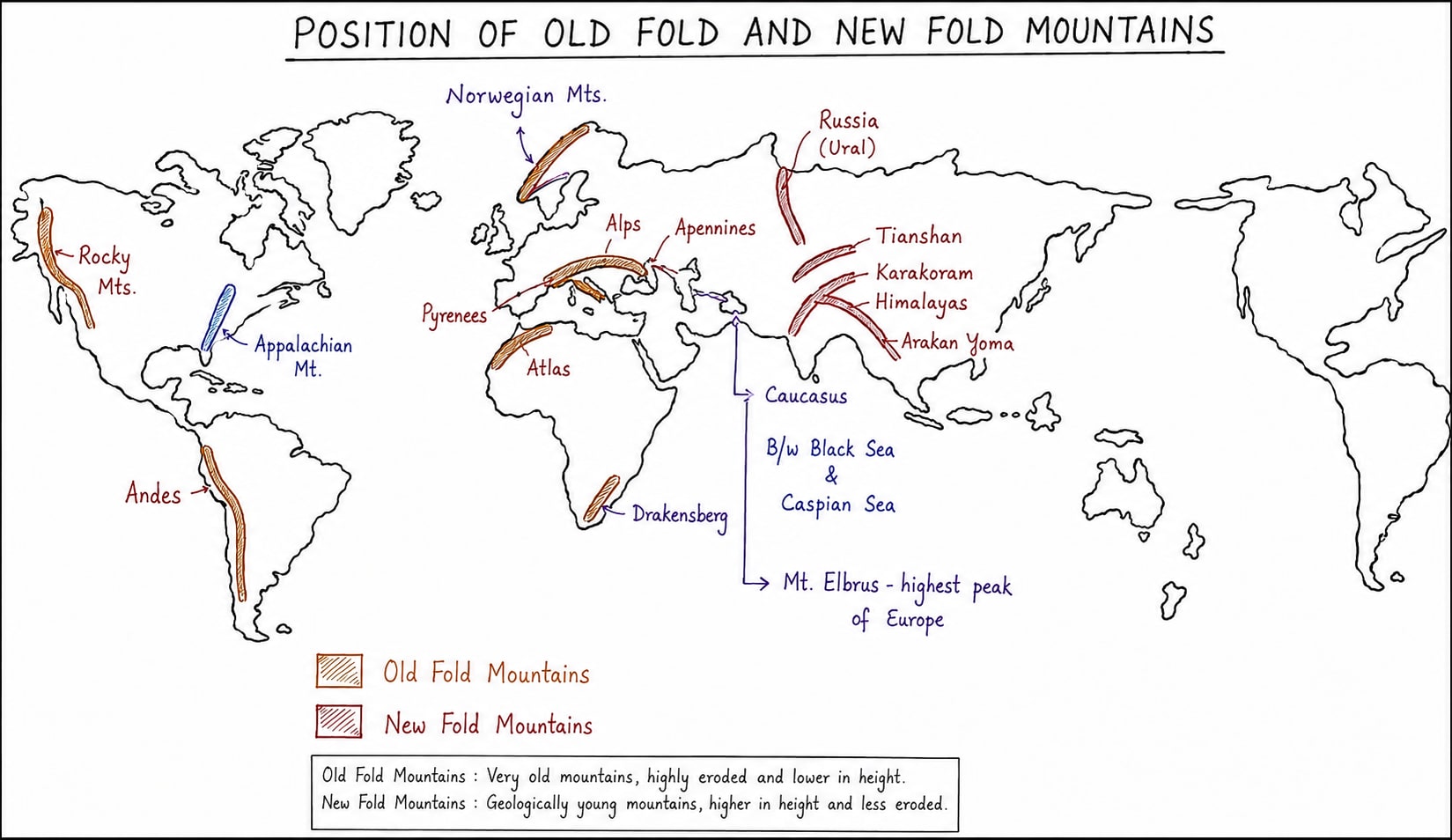
On the basis of their age folded mountains are categorize in two:-
Old Folded Mountains:- These were formed before the rupturing of this Pangea. It includes
Appalachian Mountains
Norwegian Mountain
Ural Mountain
Pennine Mountain
Drakensberg Mountain
Aravalli
Tien-Shan Mountain, etc.
New Folded Mountains:-
Andes, South America
Alps, Europe (France, Germany, Switzerland)
Apennine, Italy
Pyrenees, between France and Spain
Dinaric Alps, Along with eastern coast of Acratic Sea
Kunlun Mountains, China
Himalayas, Asia
Arakan Yoma, Myanmar
Southern Alps, New Zealand
Block Mountains
Block Mountains is a mountain formed when large block of earth crust are uplifted due to faults caused by tectonic forces. e.g. Black Forest of Germany, Vosges of France, Sierra Nevada of North America, Wasatch of North America, Vindhya range, Satpura range, Ajanta Range of India.
Horst is a type of block mountain. It is an uplifted block between two faults.Graben is a depressed part on the either side of horst.Rift Valley is a valley lane between two block mountains. e.g.
Narmada Rift Belt between Vindhya Range and Satpura Range
Tipu Rift Valley between Satpura Range and Ajanta Rang
Rhine Rift Valley between Vosges Range of France and Black Forest Range of Germany.
Volcanic Mountains
These are formed along with plate convergence zone, central eruption like Mt. Stromboli.
Formed along with plate divergence, fissure eruption e.g. Mid Atlantic Ocean Ridge-longest mountain range in the world (On the continents longest mountain range is Andes of South America)
Relic Mountains
These are called residual mountains also which are formed due to weathering and erosion in the end stage of life of every mountain e.g. Aravalli, Eastern Ghats, Ural, etc.
Plateau
Plains
Plains are surfaces of minimum relief. These are formed due to erosion and deposition by various agents like river, wind, glaciers, etc and all such plains are known with different names like-
Plains formed by rivers are called Alluvial or Peneplain.
Plains developed by wind are called Pediplains.
Plains developed by coastal waves are called coastal plains.
Rocks and Rock Cycle
Igneous Rocks
Igneous rocks formed from the cooling and solidification of molten rock material called lava.
Igneous rocks do not contains layers.
Igneous rocks do not content fossils.
Classification of Igneous Rocks
They are classified based on their formation environment, mineral composition.
On the basis of formation environment
Intrusive Igneous Rocks:- Intrusive igneous rocks are called Plutonic rocks also which are formed due to slow cooling and solidification of magma beneath earth surface e.g. gabbro, granite
Extrusive Igneous Rocks:- These are formed when lava cools quickly on the earth surface e.g. basalt and andesite.
Hypabyssal Igneous Rocks:- These are formed at intermediate depth.
On the basis of their composition
Felsic:- Silica content is greater than 66% e.g. granite.
Intermediate:- Silica content is between 52-60% e.g. Diorite.
Mafic:- Silica content is between 45-52% e.g. basalt.
Ultramafic:- Silica content is less than 45% e.g. Peridotite.
Sedimentary Rocks
Sedimentary rocks are formed through the accumulation, compaction and cementation of minerals and organic substances over time.
Sedimentary rocks have clear layers.
Sedimentary rocks contains Fossils.
Formation of Sedimentary Rocks
Sedimentary rocks are formed through
Weathering and erosion
Transportation of eroded material
Deposition of sediments
Compaction
Cementation
Types of Sedimentary Rocks
Sedimentary rocks are classified into three main types based on their origin and composition
Clastic Sedimentary Rock:- These are formed from fragments of pre-existing rocks compacted and cemented together e.g. sandstone, shale.
Chemical Sedimentary Rock:- These are formed thorough chemical reaction, evaporation of water e.g. limestone.
Organic Sedimentary Rock:- These are formed from the accumulation of organic materials from plants and animals e.g. coal, chalk.
Metamorphic Rocks
Metamorphic rocks are formed from the transformation of pre-existing rocks under conditions of high temperature, pressure or chemically active fluids without melting. This process is called metamorphism.
Metamorphic rocks have relatively high density and firmness.
These have layers if metamorphism have taken out of sedimentary rocks e.g. anthracite coal.
It has no layers if its formed out of igneous rocks.
It may or may not contain fossils.
Formation of Metamorphic Rocks
Metamorphism occur through
High temperature i.e. 200o to 800o C
Pressure
Chemically active fluid like very hot water
Time because it take thousands to millions of years
Types of Metamorphism
Contact Metamorphism:- It is caused by heat from nearby magma.
Regional Metamorphism:- Large scale metamorphism during mountain building.
Dynamic Metamorphism:- Caused by faulting e.g. Vindhyan Range.
Hydrothermal Metamorphism:- Mostly in oceans.
Rock Cycle
Rock cycle illustrate how rocks are formed, broken down and transformed into new rocks type through the process like melting, cooling, weathering, erosion, compaction, cementation and metamorphism. It is dynamic system with no fixed starting points as rocks can transition between types in various ways depending on environment conditions.
Process and Transition in Rock Cycle
Igneous to Sedimentary:- When igneous rocks are exposed on the surface. These are subjected to weathering, erosion, transportation, cementation and compaction to form sedimentary rocks e.g. granite and sandstone.
Sedimentary to Metamorphic:- When sedimentary rock is subjected to high pressure or chemically active fluid due to burial or tectonic activity then the sedimentary rock is metamorphized e.g. limestone to marble, sandstone to quartzite, shale to slate.
Metamorphic to Igneous:- When metamorphic are subjected to high temperature beyond melting point e.g. gneiss to basalt and quartzite to basalt.
Igneous to Metamorphic:- It is formed when igneous rock is subjected to high temperature and pressure below melting point e.g. granite to gneiss and basalt to amphibolite.
Sedimentary to Igneous:- When sedimentary rocks are exposed to high temperature beyond melting point e.g. sandstone to diorite.
Metamorphic to Sedimentary:- When metamorphic rock is subjected to erosion, transportation, deposition and cementation e.g. marble to limestone, quartzite to sandstone and eclogite to mudstone/shale.
Weathering and Erosion
Weathering is a natural process by which rocks, soils and minerals are broken down or altered at or near the earth surface through physical, chemical or biological means. It is a key initial step in the rock cycle as it break down igneous, sedimentary and metamorphic rocks into smaller particles or altered minerals that can be eroded, transported and eventually formed sedimentary rock.
Weathering is essentially breaking or rock in situ. In this weathered rock materials fell down at the bottom. Weathered rock materials are not transported away. Weathering provides a foundation or base to many of erosional activities.
Types of Weathering
Weathering is classified into three main types based on the mechanism of breakdown
Physical Weathering
The physical breakdown of rocks into smaller fragments without changing their chemical composition. Process include:-
Thermal Expansion:- Rock expand or contract due to temperature changes causing stress and cracking.
Frost Action:- Water enter cracks in rocks, freeze, expands and factures the rocks.
Exfoliation:- Outer layers of the rocks peel away due to pressure release as overlaying burden of material is eroded. Exfoliation is also called onion weathering. It is mainly associated with granite rocks.
Chemical Weathering
The Chemical alteration of rocks minerals through reaction with water air or other substances changing its composition. The process include:-
Oxidation:- Iron bearing minerals react with oxygen forming rust like compounds.
Carbonation:- Carbonic acid i.e. CO2 + H2O react with minerals specially with calcium carbonate rocks and breakdown the rocks.
Acid Rain:- Rainwater reacts with sulfur dioxide, nitrous oxide and forms sulfuric acid and nitric acid respectively. When it react with mineral present in the rock it is broken down.
Dissolution:- Minerals dissolve in water specially in acid water easily e.g. calcite minerals present in limestone dissolve in rainwater easily.
Hydrolysis:- Water reacts with minerals, forming new minerals like clays e.g. feldspar in granite turns into clay.
Biological Weathering
Breakdown or alteration of rocks by living organisms, often combining physical and chemical process. Process include:-
Root Wedging:- Plant roots grown into rocks cracks, prying them apart.
Burrowing:- Animals which live in soil break apart the rocks, exposing them to further weathering.
Organic Acid:- Lichens, Mosses or microbes secrete acid that chemically alter rock surface.
Importance of Weathering
It is most initial stage for the breaking of rock. It is usually necessary to support erosion. We know most of the erosional agents like water, wind, coastal waves are not very effective agent of erosion in their purest form. Weathering process provide require amount of sediments which acts as instrument of erosion.
Weathering process is responsible for formation of various types of soil e.g.
Soil of India
Outcome of which weathering process
Red Soil
Oxidation process, Chemical Weathering
Forest Soil
Biological Weathering
Desert Soil
Chemical Weathering
Laterite Soil
Leaching Process
Alkaline Soil
Chemical Weathering
Sandy Soil
Physical Weathering
Black Soil
Specially physical and chemical weathering of basalt rock
Bog Soil
Biological weathering
Erosion
Erosion is a process by which the rock particles are removed or displaced by natural forces like wind, water, etc. This process includes
Water Erosion:- It is most prevalent type of India caused by rain water, river water etc. This erosion id done by applying frictional force, attrition (collision of rocks with each other), saltation when rocks and the pebbles flow with water along with river belt while jumping and falling.
Wind Erosion:- Wind erosion includes
Suspension:- Fine particles are carried long distance in air.
Saltation:- Medium size particles bounce along the surface
Surface Creep:- Large particles roll along the ground.
Similarly, coastal waves and glaciers are important agents of erosion.