Comprehensive Indian Physical Geography notes for UPSC. Detailed coverage of the Himalayas, Peninsular Plateau, river systems, climate patterns, and soils.
Physiography of India
Origin and Evolution of Himalayas
The Himalayas, one of the world youngest and highest mountain ranges were formed due to tectonic process involving the collision of Indo-Australian plate with Eurasian plate. Their origin and evolution are the result of complex geological events spanning millions of years, shaped by plate tectonics, crustal deformation and erosion.
Origin of Himalayas
Tectonic Setting (Pre Collision)
Around 200 million years ago the Indian plate was part of super continent, located near the southern edge of ancient Tethys sea.
During Jurassic period, about 150 million years ago Gondwana began to break apart and the Indian plate started drifting northward.
About 100 million years ago, the Tethys ocean was subducting beneath the southern margin of Eurasian plate.
Initial Collision (50 to 55 million years ago)
Around 50 to 55 million years ago early Eocene, Indian plate collided with Eurasian plate, marking the onset of Himalayan orogeny.
Tethys ocean close as the continental crust of Indian plate began to push against Eurasian plate, initiating the uplift of proto Himalayas.
The collision was not abrupt, it involved the scraping of oceanic sediments and volcanic rocks, forming the initial Himalayan foot hills.
Evolution of Himalayas
Early Phase (50 to 30 million years ago)
The collision caused intense folding due to abduction process, formation of Indo-Tsangpo-Suture Zone, formation of greater Himalaya.
Middle Phase (30 to 10 million years ago)
Formation of main central thrust to the south of greater Himalayas, upliftment of middle Himalayas. South to middle Himalayas main boundary thrust was formed.
Late Phase (10 million years ago to present)
Formation of Shivalik and formation of Himalayan frontal fault between Shivalik and plains.
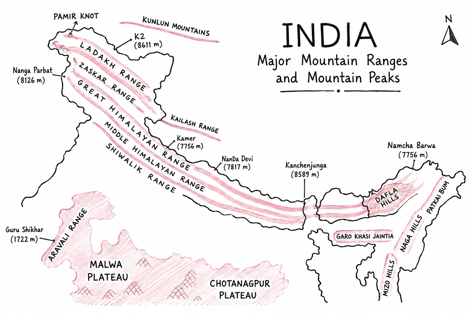
At present Himalayas are still rising. These are young folded mountains. These are about 2400km long between Nanga Parbat in Jammu and Kashmir to Namcha Barwa in Arunachal Pradesh.
Latitudinal Division of Northern Himalayas
These are mainly classified into
Trans Himalayas
The Himalayas
Trans Himalayas
Trans Himalayas extends north to Himalayas and south of Tibet. It has 3 parallel ranges
Karakoram Range
It is about 500 km long. Its highest peak is K2/ Godwin Austin (second highest peak of the world.)
K2 is highest peak of India.
Ladakh Range
It extends south of Karakulam. It is smallest among all.
Zanskar Range
It extends south of Ladakh; between Ladakh and Zanskar, Indus river flows. It is about 300km long.
The Himalayas
Himalayas has three parallel ranges
Greater Himalayas
Its average altitude is greater than 6000m.
Its highest peak is Mt. Everest in Nepal followed by Kanchenjunga in Sikkim i.e. highest peak of Himalaya in India, 8586m. Makalu and Annapurna are other important peaks.
It extends about 2400km between Pakistan, India, China, Nepal and Bhutan.
Greater Himalaya have old lake deposit which are found at high altitude. These are locally called Karewa. This Karewa soil is used for saffron cultivation.
Greater Himalayas is abode of glaciers from where numerous river originates e.g. Gangotri, Yamunotri, and Pindari, etc.
Middle Himalayas
Middle Himalayas are also known as Lesser Himalayas.
It extends south to Greater Himalayas.
It is divided into number of ranges, valleys, located between middle of Greater Himalayas include Kashmir valley and Kathmandu valley.
The ranges of Middle Himalaya include
Pir Punjab Range
It separate Jammu from Kashmir.
It paved way to National Highway 44, newly constructed railways, Mata Vaishno Devi and Patnitop hill station.
Dhauladhar Range
It is in Himachal Pradesh.
It is famous for hill station and apple cultivation.
Nag Tibba Hills
Nag Tibba range is famous for its scenic beauty and tracking enthusiast.
Missouri Hills
It is Uttarakhand.
It is called Queen of hills because of presence of beautiful hill stations.
Mahabharat Range
It extends mainly in Nepal. Kathmandu valley lie between Mahabharat range and Greater Himalaya.
Dafla Hills, Miri Hills, Abor Hills and Mishmi Hills
These are known of Middle Himalaya in Arunachal Pradesh.
Shivalik Hills
It is youngest among all three ranges.
The valleys between Himalaya and Shivalik are called Duns in the west e.g. Dehradun, Paatlidun and Dwar in the east e.g. Haridwar, Kotdwar, etc.
Shivalik also divided into multiple ranges like
Jammu Hills- Jammu
Dudhwa Hills- Uttar Pradesh
Churia Hills - Nepal India (Uttar Pradesh) border
Someshwar Hills - Nepal, India (Bihar) border
Longitudinal Division of Northern Himalayas
Kashmir Himalayas
It is also called Punjab Himalaya.
It extends between Indus river in the west to Satluj river in the east.
It include Greater Himalaya of Jammu and Kashmir, Himachal, Vir Punjab Range and Dhauladhar range and the Jammu hills of Shivalik.
It is origin point of numerous rivers including Chenab, Ravi, Vyas and Jhelum.
Kumaon Himalayas
It extends between Satluj river in the west to Kali river in the east.
It includes Greater Himalaya, Nag Tibba hills and Missouri Hills.
It is world famous for its hill stations and glaciers like Gangotri, Yamunotri and Milan, Gaumukh glacier.
Ganga, Yamuna and Alaknanda originates from here.
Nepal Himalayas
It is longest Himalayas.
It extends between Kali river in west to Teesta river in east.
It contains money highest peak including Mt. Everest and Kanchenjunga.
It has Kathmandu valley and Pokhara valley.
Various river pass through this like Ghagra, Gandak, and Kosi.
Assam Himalayas
It is second longest.
It is famous for its biological hotspot status.
It extends from Teesta to Brahmaputra river.
Important Passes in Himalayas
Pass
Location
Importance
Khardung La Pass
Ladakh
One of the highest motorable pass
Zojila Pass
Ladakh
It connect Srinagar to Lah
Banihal Pass
Jammu and Kashmir
Connects Srinagar to Lah
Burzil Pass
Jammu and Kashmir
Connect Kashmir with PoJK
Baralacha Pass
Himachal Pradesh
Connects Himachal to Tibet
Lipu Lake
Uttrakhand
Connect Kailash Mansarovar
Mana Pass
Uttrakhand
Connects India with Tibet
Niti Pass
Uttrakhand
Connects India with Tibet
Nathula Pass
Sikkim
Connects India with Tibet
Jelep Pass
Sikkim
Connects India with Tibet
Bomdila Pass
Arunachal Pradesh
Connects India with Tibet
Sela Pass
Arunachal Pradesh
Connects Tezpur of Assam to Tawang of Arunachal Pradesh
Plains
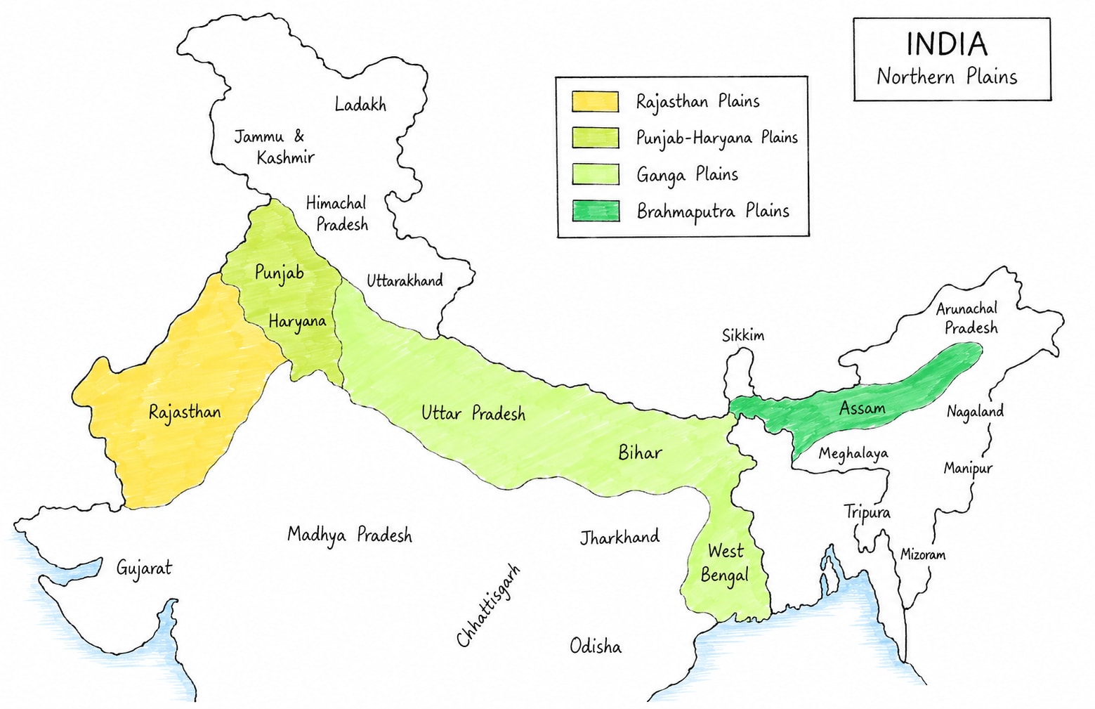
North Indian plains also known as Indo-Gangetic plains or Great Plains of India, represents youngest and most fertile physiographic division of country.
It is spanning over approximately 7 to 7.8 lac km2. They extend over 3200km including Pakistan and 2400km within India. It extends from arid region of western Rajasthan to the moist region of Brahmaputra valley in east. It has average width of 150 to 300kms. It is located between Himalayas in north and peninsular plateau in the south.
Origin of North Indian Plain
The origin of these plain traced back to the tertiary period when the convergence of Indian and Eurasian tectonic plate caused the uplift of the Himalayas, creating a deep tectonic depression or syncline between the rising Himalayas and peninsular plateau.
This depression was further accentuated by isostatic adjustments and down warping, particularly in the Gangetic plain between Rajmahal hills of Chhota Nagpur plateau and Garo hills of Meghalaya.
Over the last 2.5 million years Ganga, Brahmaputra and Indus river have filled entire depression by using their sediments.
Classification of North Indian Plains
The classification of north Indian plains is two fold
Physiographic Division
It is based on soil types and the age of alluvial. This includes
It is based on dominant river system. These are divided into following
Rajasthan Plains
It cover nearly about 1.75 lac km2 west of Aravalli range. This region is called Marusthali. This part receives rainfall less than 50 cm per annum. Luni river is the most dominant river of the region which form inland drainage system. This region is facing problem of soil salinity and expansion of desert.
East of Aravalli is called Banasthali. It receives more than 50cm to 75cm per annum. Most dominant river in north, Mahi and Sabarmati river, in the south. This region is known for its high soil fertility that's why it support large number of population. Problem in this region is soil erosion done by Chambal river.
Punjab-Haryana Plain
About 600km long and 300km wide plain which extends north and east of Rajasthan and mainly west of Aravalli. It is land of five doab which include Sindhu Sagar doab, Chaj doab, Rechna doab, Bari doab and Bist doab. It is region of green revolution but facing problem of increasing alkalinity in the soil, soil erosion by local rivers and demising result due to high use of fertilizers and chemical compounds in the past.
Ganga Plain
It is about 1400km long and 300km wide from Delhi to West Bengal, Kolkata. It is sub-divided into three parts:-
Upper Ganga Plain
It covers western UP, Ganga-Yamuna doab, Rohilkhand and Bundelkhand. It is the region of high soil fertility specially in Ganga-Yamuna doab but low fertility in Bundelkhand. The region include Kanpur, Kanoj, Saranpur, Mathura, Agra, etc.
Mid Ganga Plain
It covers eastern UP to Bihar. It features thick alluvial that's why high fertility. It covers larger part of Awadh plain in the north to Ganga that includes Gorakhpur, Prayagraj, Chapra and Varanasi, etc. south to Ganga it includes Mirzapur, Chitrakoot, Mughalsarai, etc.
Lower Ganga Plain
It includes larger part of Bihar and West Bengal. It is also known for high fertility. In the lower Ganga plain, Ganga river bifurcates. Its distributary is called Hooghly and that flows through West Bengal.
Brahmaputra Plain
It is about 720km long and 80Km wide, surrounded by eastern Himalayas and hills. It features multiple riverine alluvial island and vast alluvial plain. It is high flood prone area that's why its fertility is so high.
Plateaus
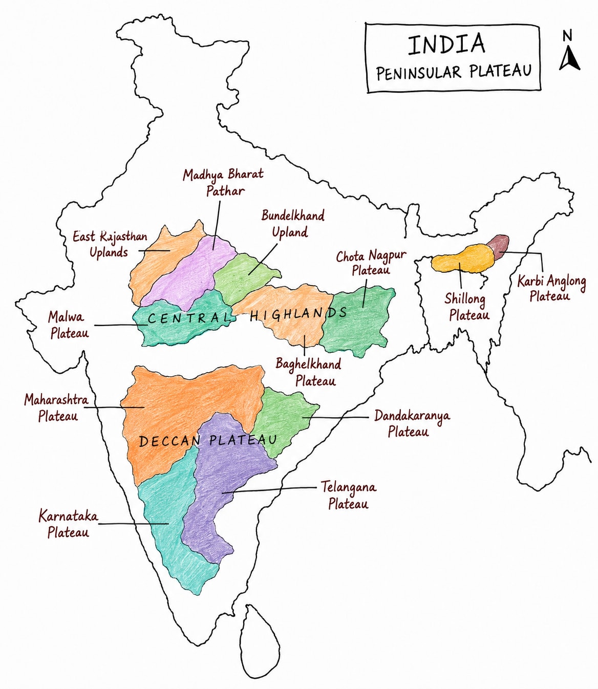
Deccan Plateau
Deccan Plateau has three main division
Maharashtra Plateau
Maharashtra Plateau form the northern part of Deccan plateau, primarily laying within the state of Maharashtra.
It has volcanic origin. It was formed due to volcanic eruption, which had taken place during cretaceous period, about 65 million years ago.
Due to this volcanic eruption Deccan traps were formed. It is a thick sequence of basaltic lava
It is drained by Godavari, Bhima and Krishna rivers.
It is known for its fertile black soil, which supports almost every type of crop.
Telangana Plateau
It is situated primarily within Telangana state.
It was also formed through volcanic eruption.
This is drained by Godavari, Krishna and Moosi river.
It is very rich in iron ore, limestone and coal.
Karnataka Plateau
It lies in the southern part of Deccan plateau.
It extends in Karnataka and Tamil Naidu primarily.
It is drained by Kaveri and Tungabhadra river.
It is very rich in gold, iron ore and limestone.
Central Highlands
Chhota Nagpur Plateau
It is richest among all central highland plateau.
It has oldest rock in India about 2.5 billion year old (The first which came out of sea).
Its rocks include Dharwad and Gondwana rock series.
It is drained by Damodar river, Subanrekha river, North Koel and south Koel river.
It is rich in coal (Gondwana rocks series) and iron ore (Dharwad rock series).
Other minerals are Mica, Bauxite and Uranium.
Meghalaya Plateau
Meghalaya plateau is extension of Chhota Nagpur plateau.
It is divided into three parts
Karo
Kasi
Jaintia
Shillong is the highest point.
Cherapunji and Mawsin ramp are situated in Kasi hills.
It is drained by southern tributers of Brahmaputra.
It is rich in coal, limestone and sillimanite.
Marwar Plateau
It lies in western Rajasthan, west to Aravalli.
It is predominately a sandy plain that includes bad land.
It is drained by Luni river primarily and other seasonal rivers.
It is rich in gypsum, lignite, gems and sandstone.
Madhya Bharat Pathar
It covers south-east Rajasthan and north-western Madhya Pradesh.
It is spread east to Aravalli range.
It is drained by Chambal and Betwa river.
It is rich in limestone, diamonds (Panna).
Bundelkhand Plateau
Bundelkhand plateau lies east to Madhya Bharat Pathar and Malwa plateau.
It is composed of Bundelkhand gneiss, it is India's oldest rock.
It is drained by Betwa and Ken river.
It is rich diamonds, granite and sandstone.
Baghelkhand Plateau
It is between bundelkhand and Chhota Nagpur plateau.
It lies in the north-eastern Madhya Pradesh.
It is drained by Son, Rewa and northern tributaries of Mahanadi.
It is rich in bauxite, coal and limestone.
Malwa Plateau
It lies in north-western Madhya Pradesh and south-eastern Rajasthan.
It is drained by Chambal river and Narmada and Mahi river.
It is rich in limestone and sandstone.
It is also arid plateau.
Mountains and Hills of Peninsular India
Aravalli Hills
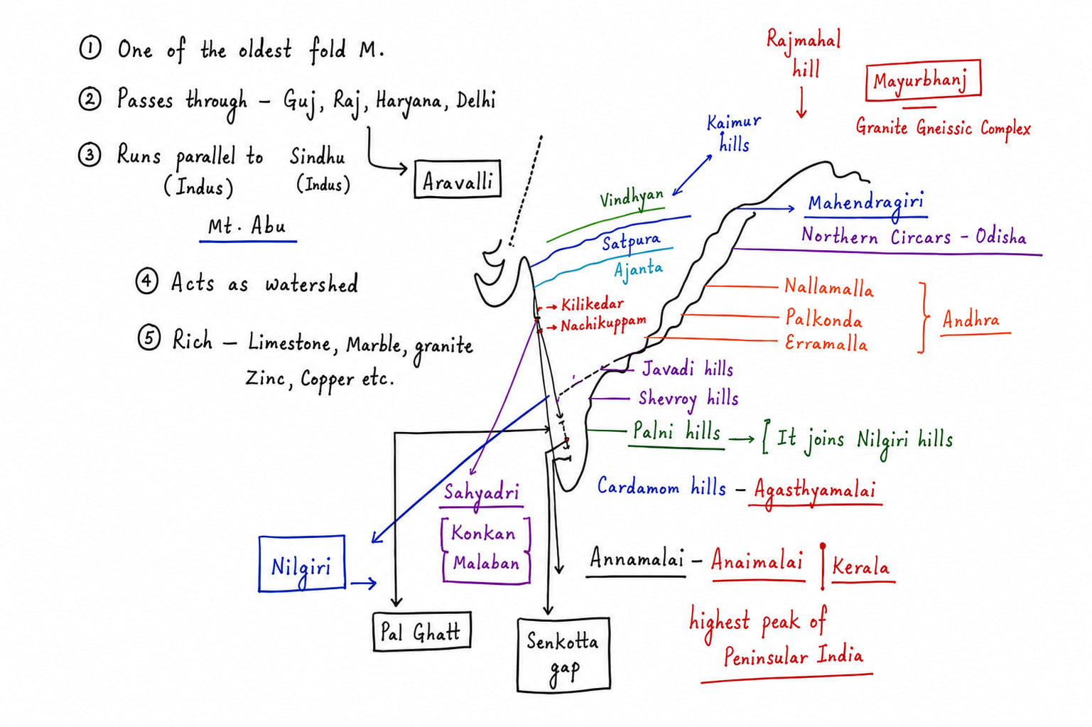
Aravalli range is one of the oldest mountain range in the world stretching approximately for 800kms from Gujrat to Delhi across Indian states of Gujrat, Rajasthan, Haryana and Delhi.
Its highest peak is Guru Shikhar in Sirohi district of Rajasthan.
It is an example of old folded mountains.
It was formed about 1.8 to 2.5 billion years ago that's why it is considered as one of the oldest mountain range in the world.
It forms barrier between Thar desert and the fertile easter Rajasthan.
It is very rich in marble, granite, zinc, cooper and talc.
It is origin point of number of rivers like Luni, Sabarmati, Mahi, etc.
Vindhyan Range
It is about 1050km long east to west running mountain.
It is an example of block mountain
Its highest peak is Sadbhavna Shikhar (Amarkantak).
It form northern edge of peninsular India.
It was formed about 1.6 to 1 billion years ago.
Number of rivers originates from here like Son, Ken, Betwa, Chambal, etc.
It is rich in various minerals like limestone, bauxite, sandstone and diamond mine in Panna.
Satpura Range
It is about 900km long range runs parallel to Vindhyan range. These two ranges are separated by Narmada rift valley.
It is example of horst.
Its highest peak is Dhupgarh in Pachmarhi, Madhya Pradesh.
Gawaligarh hills, Mahadev hills are its branches/ part.
It was formed during 65 to 60 million years ago during Narmada Tapi rift valley formation.
Number of rivers originates from here like Hiren, Tawa, etc.
It is rich in coal, manganese, bauxite, limestone, copper.
Western Ghats
Western Ghats extends from Gujrat to Tamil Nadu via Maharashtra, Goa, Karnataka and Kerala.
It is about 1600km long parallel to Arabian Sea.
Its highest peak in Anamudi (2695m) it is Anamali hills, Kerala.
It is known with different names with different parts.
Sahyadri Hills
Mainly in Gujrat, Maharashtra and Goa.
It has two famous peaks
Kalsubai, Nasik (Godavari originates nearby)
Mahabaleshwar, Satara (Origin point of Krishna).
Sahyadri Hills has two important passes
Thal Ghat (Mumbai to Nasik)
Bhor Ghat (Mumbai to Pune)
Nilgiri Hills
It is called in Karnataka and Tamil Nadu mainly.
Highest peak of Nilgiri is Doddabetta. It is in Tamil Nadu
At Nilgiri Eastern Ghat join Western Ghat in Tamil Nadu
Nilgiri is famous for Tea.
Annamalai
It is separated from Nilgiri by Palghat gap.
It is about 80km wide through this south-west enter into Karnataka and rains over Udupi, Bangalore and parts of western Tamil Nadu.
Annamalai extends into Tamil Nadu and Kerala.
Its highest peak is Anamudi and it lies in Kerala.
Cardamom Hills
Cardamom hills are separated from Annamalai hills by Shencottah Gap.
The highest peak of Cardamom hills is Agasthyamalai.
Cardamon hill is famous for cultivation of cardamom.
Eastern Ghats
Eastern ghats are example of old folded mountain.
Its average length is about 1500km and it runs parallel to Bay of Bengal.
It extends from Odisha to Tamil Nadu via Andhra Pradesh and parts of Karnataka.
Its highest peak is Mahendra Giri which lies in Odisha.
It is rich in bauxite, manganese, iron ore.
It is also famous for its red sanders trees which are found Seshachalam and Nalla Malla hills.
India's 50% bauxite and 95% chromite comes eastern ghats.
Rajmahal Hills
It is about 200km long extends mainly only in Jharkhand and West Bengal border.
It lies 90% in Jharkhand and 10% in West Bengal.
It was outcome of volcanic activity that's why it also called Rajmahal trap also.
It is rich in coal, China clay and uranium.
Rajmahal Gharogap
It is gap between Rajmahal hills in the west and Gharo hills in the east (Meghalaya Plateau).
It extends about 400km east to west.
It was formed due to upliftment of Shillong plateau when Indian plate hit and compressed against Eurasian plate in the east about 50 to 30 million years ago.
It has now a fertile soil which supports second most densely populated state of India.
It is separated from Satpura range by Tapi rift valley
It is very famous for its dense forest cover.
It is rich in coal, iron ore and bauxite
Coastal Plain of India
Indian coast line is 11098.81 km. It is up from previous 7516 km due to update calculation methodologies and higher resolution geospatial mapping. This revised total consist of 7870.51 km of mainland coast line and 3228.30 km of island territories.
The longest mainland coastline is of Gujrat i.e. 2340.60 km and the longest overall coastline of Andaman and Nicobar island 3083.50 km
Shortest coastline is of Goa 193 km
Indian coastline is mainly in two parts.
Western Coastal Plain
Eastern Coastal Plain
Western Coastal Plain
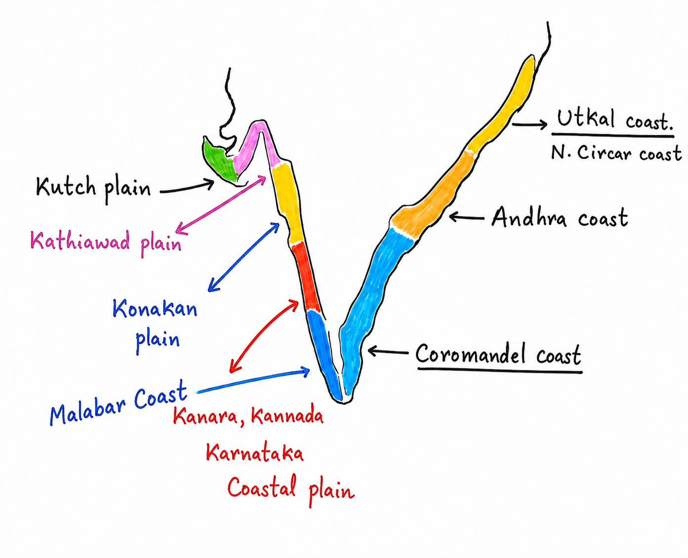
It extends from Run of Kutch of Gujarat to Kanyakumari/ Cape Comorin.
It lies between western ghats and Arabian sea.
It is an example of submergent coast.
It is divided into many parts.
Gujrat Coast
Gujrat Coastal Plain is mainly divided into two parts
Kutch coastal Plain
It is the western most part of Gujrat.
It is full of marshy areas, saline lakes, creeks
Kathiawar Plain
It extends all across the Gulf of Khambhat, on either side.
It is full of estuaries of rivers like the Sabarmati, Mahi, Narmada, and Tapi.
Konkan Coast
The Konkan Coast extends from Daman in the north to Goa in the south.
It is a rocky coast.
It is characterized by numerous creeks and small river valleys, such as those of the Ulhas, Savitri, and Vashishti rivers.
Major cities on this coast include Mumbai and Goa.
Kanara (Kannada) Coast
The Kanara (Kannada) Coast extends from Goa to Mangaluru.
It is famous for its numerous waterfalls.
South of Goa, the Western Coastal Plain becomes very narrow.
Malabar Coast
The Malabar Coast extends from Mangaluru to Kanyakumari.
It is famous for its lagoons and backwaters.
Backwaters are narrow channels of seawater that extend inland.
In Kerala, backwaters are locally called Kayals.
These are famous for houseboats and Vallamkali.
It is famous of Vemebnat lake and Ashtamudi lake.
Eastern Coastal Plain
Eastern coastal plain stretches from West Bengal in the north to Kanyakumari in south. It is an example of emergent coast. It is often wider than western coast. It lies between eastern ghats and Bay of Bengal.
It is divide into three regional parts.
Coromandel Coast
It lies primarily in Tamil Nadu
It is famous for its Kaveri delta.
Major cities are Chennai, Tutikorine.
Northern Sarkar
It mainly covers Andhra Pradesh thus called Andhra coast also.
It has famous Godavari delta, Krishna delta and Kolleru lake.
Uttakal Coast.
It is mainly in Odisha.
It is famous for Mahanada Bhramini delta and Chilka Lake.
It is famous for olive ridley turtles, which are endangered species.
Island
Andaman and Nicobar Island
Andaman and Nicobar islands are UTs and it is the one of the most important island territory due to its location near Strait of Malacca i.e. one of the busiest maritime trade route.
It is union territory since 1956.
It has island, islets and rocky outcrops more than 800
Inhabitant island 31
It has three district
Northern and Middle Andaman
Southern Andaman
Nicobar
Its highest peak is Saddle peak and the altitude is 732 m.
Its southern most point is Indira point in Great Nicobar.
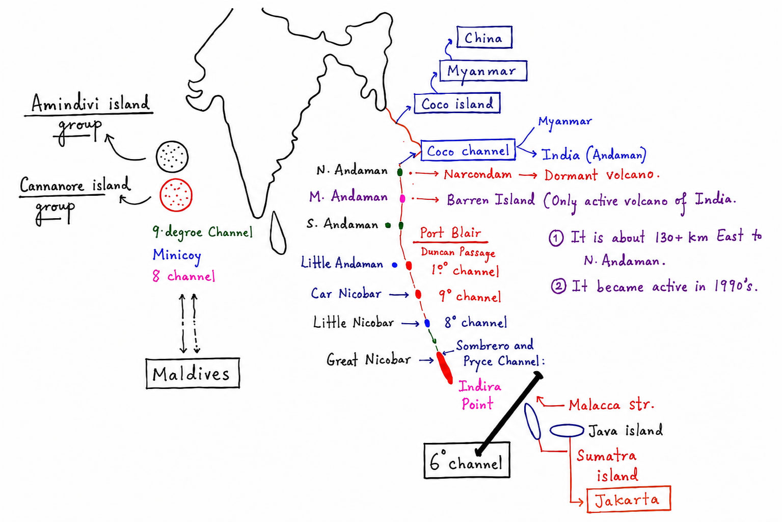
It is separated from Myanmar by Coco channel and from Indonesia, Sumatra island by 6 degree channel.
Formation of Andaman and Nicobar Island
The island are part of Arakanyoma mountain system which continues under water from Myanmar to Indonesia.
It was formed due to convergence between Indo-Australian plate and Burma plate.
Indian plate is subducting beneath Burman plate.
Division of Islands
Andaman Group
Northern Andaman / Narcondam Island
Extinct Volcano
Middle Andaman
Barren Island
Only active volcano of India
130+ km east from middle Andaman
Eruption started in 1990s
Southern Andaman
Port Blair
Duncan Passage
It is a water channel. It separates southern Andaman from Little Andaman
Nicobar Group
Car Nicobar
It is separated from Little Andaman by 10° Channel
Little Nicobar, Nancowry Island
Great Nicobar
Great Nicobar is separated from rest of Nicobar group by Pryce Channel and Sombraro Channel
Great Nicobar has southern most point of India i.e. Indira point.
6° Channel
It separates Andaman Nicobar and Indonesia.
New Name Changes
Old Name
New Name
Ross Island
Netaji Subash Chandra Bose Dweep
Havelock Island
Sawaraj Dweep
Neil Island
Sayid Dweep
Besides this on 23rd January 2023 government of India name 21 previously unnamed island after 21 Param Vir Chakra recipients.
Important Tribes of Andaman
Andaman Tribes
Great Andamanese
Jarawa
Onge
Sentinelese
Nicobar Tribes
Nicobarese
Shompen
Lakshadweep
Lakshadweep has a literal meaning of a region where thousands of island are. British called it Laccadivi islands. It is group of more than 36 coral islands in Arabian sea. It is smallest UT of India. It is governed by central government. It has three major group of island
Amindivi island
It is northern most group.
Important island are Amini, Kadmad, Kiltan, Cheltan and Bitra.
Cannanore island
It is called Laccadivi island also.
It is central group of island.
Its important island are Androdd, Kavaratti(capital), Kalpani, Agatti and Bangran.
Minicoy island
Minicoy is the largest island.
It is separated from Cannanore island group by 9° Channel and from Maldives by 8° Channel.
The official language of Lakshadweep
It is famous for its high biodiversity, coral formation, eco tourism.
It is inhabited by schedules tribes mostly there follower of Islam (unlike Andaman and Nicobar PVTs are there)
Drainage System of India and Drainage Pattern
Himalayan drainage system is mainly categorized into two
Antecedent River System
Consequent River System
Antecedent River System
An antecedent river system is a river that existed before the formation or uplift of the present day mountains or landforms. As the land gradually rises due to tectonic forces the river maintains its original course by cutting down into the rising terrain through vertical erosion.
Formation
River established its course on a relatively flat surface.
Tectonic uplift, mountain building occurs slowly.
The river erodes downward at a rate equal to or greater than the uplift.
Deep gorges are formed.
Characteristics
These river are older than mountain range.
Cuts across mountain ranges instead of flowing around them.
Form deep valleys, gorges and canyons
e.g. are Satluj river cuts through Himalayas and enter into India through Shipkila pass, Himachal Pradesh, Brahmaputra river cuts through Himalaya and enter into India through Arunachal Pradesh and forms Yarlung Tasngpo or Brahmaputra gorge, similarly Indus river, Kosi river, Gandhak river, Gagra river, etc.
Consequent River
Consequent river are those river which follow the regional slope gradient. If slope gradient changes it also changes its course e.g. Ganga, Yamuna, etc.
Himalayan rivers are categorized mainly into two
West flowing rivers of Himalaya - Indus River System
East flowing rivers of Himalaya - include Ganga and Brahmaputra rivers system
Peninsular Rivers
Peninsular rivers are of two types
East flowing - which drain into Bay of Bengal like Subarnarekha, Brahmani, Mahanadi , Godavari, Krishna, Kaveri, etc.
West flowing - which drain into Arabian seal like Luni, Sabarmati, Mahi, Narmada, Tapi, Mandovi, Juari, Peiyar, Pambiyar, Pamba, Bharathapuzha, etc.
Drainage Patterns
Diverse physiography which has given diverse drainage pattern. Drainage pattern means the direction of river flow, the way tributaries of main river join them e.g. at which angle, etc. Major drainage patterns are
Dendritic Pattern
It develops on uniform rock surface, resembles the branches of a tree.
Tributaries of the main river join it at acute angle along with a gentle slope.
e.g. Ganga, Godavari, Krishna, Indus, etc.
Trellis Pattern
In this river flow parallel to the hills and tributaries join the main river at right angle.
e.g. rivers of Vindhyan and Satpura range region.
Centrifugal Pattern
It is called radial pattern also.
In this river flow outward from a central highland.
e.g. Amarkantak plateau from where Son and Narmada originates and radiate out in different directions
Centripetal Pattern
where number of rivers flow into a common depression
e.g. Lake Loktak of Manipur, Lake Sambhar of Rajasthan.
Linear Pattern
When river flow parallel to each other.
e.g. rivers flowing out from the western slope of western Ghats.
It is called parallel drainage pattern also.
Factors Influencing Drainage pattern in India
Relief and Slope
River flow from high to low areas/ slope gradient.
Geological Structure
Hard and soft rocks influence direction and shape of the river because soft rocks are eroded more than the hard rock e.g. Trilece pattern
Climate and Rainfall
Heavy rainfall creates dense drainage network e.g. Assam, Manipur whereas dry region may have sessional and inland drainage e.g. western Rajasthan.
Topography
It includes mountains, plateaus, depression, etc. e.g. radial or centrifugal drainage system in plateau area and dendritic drainage system in plain areas.
Himalayan River System
Indus River System
Indus river system is one of the three major Himalayan river system of India.
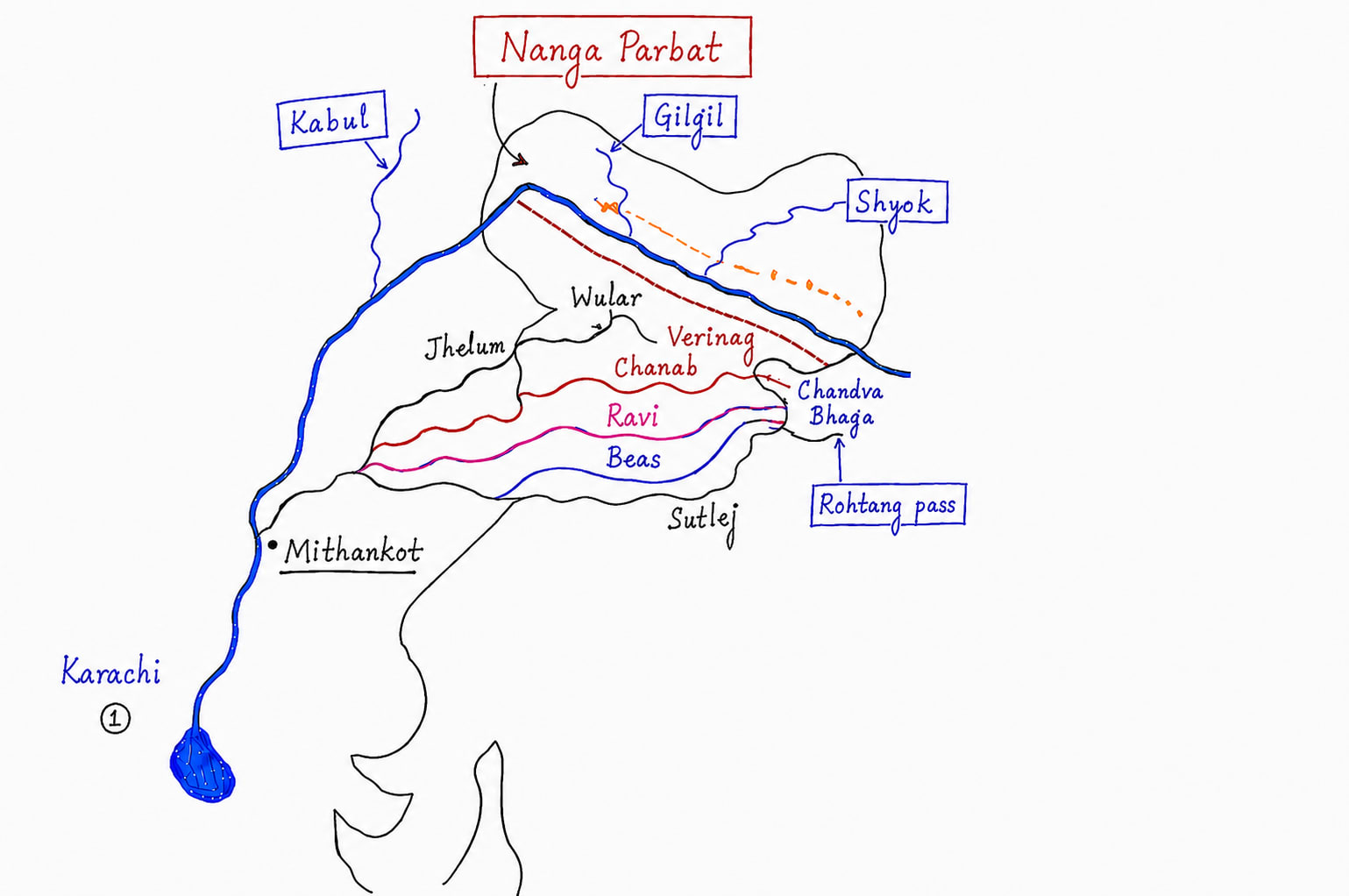
Indus river originates from near lake Mansarover close to the Kailash range in Tibet, China
It enters India near Themchok of Ladakh.
It flows through Ladakh then into Pakistan and finally empties into Arabian sea east to Karachi.
It flows through Indian states and UTs of Ladakh, J&K, Punjab, Himachal Pradesh (Indus river system).
Its tributaries are
Left Hand Tributaries
Jhelum
Originates of Verinag spring of J&K flows through Wular lake and Srinagar
Chenab
It is formed due to confluence of Chandra and Bhaga rivers at Tandi, Himachal Pradesh. It is largest tributary by volume of water
Ravi
Originates from Rohtak pass of Himachal and forms border between India and Pakistan.
Beas
Originates from Vyus Kund near Rohtak pass. It flows entirely in India
Satluj
Originates from Lake Rakas, Tibet, China. It is longest tributary of Indus.
Right Hand Tributaries
Shyok
Gilgit
Nubra
Hunza
Sihgar
Zanskar
Major dams and hydropower projects
River
Project
Satluj
Bhakra Nangal Dam, Nathpa Jhakri and Karcham Wangtoo
Beas
Poong Dam, Pandoh Dam
Ravi
Ranjeet Sagar Dam. It is called Thin Dam also, Shahpur Kandi Project
Indus water treaty was signed between India and Pakistan in 1960 at Karachi. This was mediated by World Bank. As per this treaty India share 80% water of west of the west flowing rivers of Indus and tributaries which include Indus, Jhelum and Chenab and make use of east flowing tributaries of Indus for its own that includes Ravi, Beas and Satluj.
However following April, 2025 Pahalgam terrorist attack India announce that it had placed Indus water treaty in abeyance. Before terrorist attack, after Uri attack also India had made this strong decision and conveyed this to Pakistan that it won't be respecting this agreement unilaterally
Brahmaputra River System
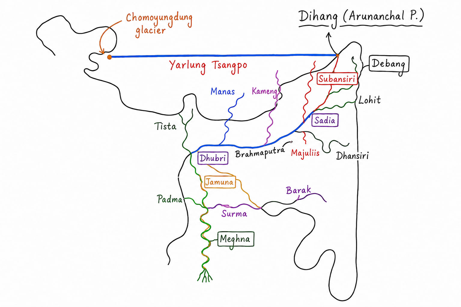
Brahmaputra river originates from Choma Yung Dung or Angasi glacier of Tiber near Mt. Kailash.
It flows eastward and called Yarlung Tsangpo.
It takes dramatic U trun and enter into Arunachal Pradesh from near Namchabarva peak.
In Arunachal Pradesh it is called Dihang or Siang.
In Assam, near Sadiya where Lohit river joins Dihang it gets its name Brahmaputra and it called Brahmaputra uptill Dhubri/ Assam.
Thereafter it enter into Bangladesh as Jamuna. Their it is joint by Padma (Ganga) and together these are called Megna which forms Ganga Brahmaputra delta.
It flows through state of Arunachal and Assam.
Major tributaries are
Left hand tributaries
Dibang, Arunachal
Lohit, Arunachal
Dhansiri, Nagaland Assam
Kopili, Meghalaya Assam
Right hand tributaries
Subansiri, Arunachal
Kamang (Gia Bharali), Arunachal and Assam
Manas, Bhutan and Assam
Sankosh, Bhutan and Assam
Beki, Bhutan and Assam
Raidak, Bhutan West Bengal and Assam
Tyista, Sikkiam and West Bengal and join Brahmaputra in Bangladesh
River
Project
Subansiri
Lower Subansiri Hydropower Project
Kamang
Kamang Hydropower Project
Dibang
Dibang Multipurpose Project
Siang
Upper Siang Hydropower Project (proposed)
Ranganadi
Ranganadi Hydroelectric Project
Ganga River System
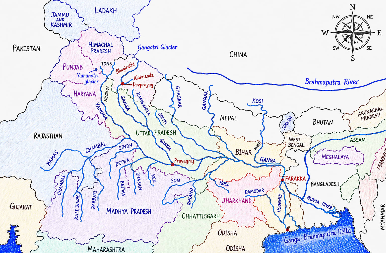
Ganga river system is most important river system of North-Indian plain and one among three Himalayan river system.
Ganga river originates as Bhagirathi River from Gangotri Glacier, from Gaumukh, Uttarakhand at the attitude of 3892 m.
At Devprayag Alaknanda joins Bhagirathi and from this point the river is officially called The Ganga.
Alaknanda river originates from Satopanth and Bhagirathi Kharak glacier near Chaukamba peak Uttarakhand.
Alaknanda carries more water than Bhagirathi before meeting at Devprayag.
Major tributaries of Alaknanda are
Dholi Ganga
Nandakini
Bindar
Mandakini
Panchprayag (five scared confluences)
Vishnuprayag: Alaknanda + Dholi Ganga
Nandprayag: Alaknanda + Nandakini
Karnprayag: Alaknanda + Bindar
Rudhraprayag: Alaknanda + Mandakini
Devprayag: Alaknanda + Bhagirathi
It is right sequence of Panchprayag north to south.
Ganga river thereafter i.e. after Devprayag flows through Rishikesh and Haridwar.
Near Farakkha Barrage near West Bengal Ganga is bifurcated and formed a distributary called Hugli. Hugli rivers flows through West Bengal north to south. Kolkata city is situated on it.
After Farakka Barrage the main river flows through West Bengal as Bhagirathi river
After entering into Bangladesh it is called Padma river where it is joined by Jamuna and together these are called Meghna which formed Sundarbans delta i.e. largest delta in the world.
Tributaries of Ganga
Left Bank Tributaries
Ram Ganga
Ram Ganga originates from Ghadwal Himalaya, Uttarakhand.
It flows through Uttarakhand and Uttar Pradesh.
It joins Ganga at Kanoj.
Important Dams is Kalagarh Dam also called Ram Ganga dam.
Gomati River
Gomati River originates from Gomat Taal, Pilibhit district of Uttar Pradesh
Major cities situated on it are Lucknow, Sultanpur and Jaunpur.
It joins Ganga east to Varanasi at Ghazipur.
Major barrage is Gomati barrage.
Ghaghra River
It is called Karnali river in Nepal.
It originates form Mapchachungo glacier, Tibet.
It joins Ganga near Chaapra and forms Northern border between Uttar Pradesh and Bihar.
It important tributary is Sarda and Sarju on which Ayodhya is situated.
Its other important tributary is Rapti on which Gorakhpur is situated which is famous for Gorakhnath Temple. Gorakhnath was founder of Nath sept.
The major dams on Ghaghra are
Girijapuri Barrage in India.
Karnali Hydropower project in Nepal.
Gandak River
It is called Narayani river also.
It originates from Nepal Himalaya between Dhaulagiri and Annapurna.
This river joins Ganga near Patna, Bihar.
Major dam is Valmiki Barrage.
Budhi Gandak River
Budhi Gandak originates from Someshwar Hills, west Champaran, Bihar
It flows completely in Bihar and joins Ganga near Khagaria, Bihar.
Kosi River
Kosi river originates from Tibet as Arunkosi, Sonkosi, Tamurkosi.
It joins Ganga at Kursela, Katihar of Bihar.
It is called Sorrow of Bihar.
Famous dam is Kosi Barrage at Bhimnagar.
Mahananda River
Mahananda river originates from Darjeeling hills West Bengal from their it enter into Bihar, again goes back into West Bengal and finally joins Ganga in Bangladesh.
In 2025-26 under National Mission for Clean Ganga, a master plan has been aproved to restore Gomati rivers origin site at Pilibhit focusing on ecological restoration and cultural heritage.
The first bassin wide Gharial survey released in 2026 has covered 13 rivers of Ganga bassin. After the Chambal important Gharial populations were also recorded in Ghagra Girwa river system.
Right Hand Tributaries of Ganga
Yamuna River
Yamuna River Originates from Yamunotri glacier, Bandarpoonch peak Uttarkashi, Uttarakhand.
Elevation is 6315m.
It flows through Uttarakhand, Himachal Pradesh, Haryana, Delhi, Uttar Pradesh (5 states).
It joins Ganga at Prayagraj.
It is largest tributary of Ganga.
Major tributaries of Yamuna are
Left Hand tributaries
Tons
It is largest tributary of Yamuna from left hand side.
Hindon
Hindon originates from Saharanpur, UP and joins Yamuna near Noida.
Right Hand Tributaries
Chambal
Originates from Janapav hills, Vindhyan range, Madhya Pradesh.
It joins Yamuna near Itawah.
Its major tributaries are
Banas
Kali Sindh
Parvati
Shipra
Major dams of Chambal are (south to north)
Gandhi Sagar
Rana Pratap Sagar
Jawahar Sagar
Kota Barrage
Chambal is famous for
Ravines
-Gharial, Magar and Crocodile
Gangetic Dolphin habitat.
It flows through three states UP, MP and Rajasthan.
Sindh
Sindh river originates from Vidisha district of Madhya Pradesh.
It joins Yamuna near Itawah district, Uttar Pradesh.
The famous dam on it is Manikheda Dam
Betwa
Betwa river originates from Vindhyan hills near Bhopal.
Important dams on Betwa river are
Mata Tilla Dam
Raj Ghat Dam
Parichha Dam
Ken
Ken river originates from Katni district of Madhya Pradesh and joins Yamuna near Chilla, Uttar Pradesh.
Major dam is Gangau Dam.
It passes through Panna Tiger reserve of Madhya Pradesh.
Karmnasa River
Karmnasa river originates from Kamur hills.
Vindhyan range in eastern UP and Bihar known as Kamur hills.
It joins Ganga near Buxar at Chausa.
It forms border between UP and Bihar.
Important dams on this river are
Latif Shah Dam
Durgavati Reservoir
Son River
Son river originates from Amarkantak plateau, MP.
It flows through MP, UP, Jharkhand and Bihar.
It joins Ganga west to Patna.
Its tributaries are
North Koyel
Rihand
Johila
Major dams are
Indrapuri Barrage, Bihar
Rihand Dam
Bansagar Dam
It second largest right bank tributary of Ganga after Yamuna.
Punpun River
It originates from Chota Nagpur Plateau, Jharkhand.
It joins Ganga east to Patna city.
Falugi is tributary of Punpun on which Bodh Gaya is situated.
Ken Betwa river linking project remains India's first river linking project under implementation.
In 2026 researchers from IISER, Bhopal and University of Delhi has reported that Yamuna in Delhi has shrunk by 68% over the last 200 years, highlighting the impact of urbanization, encouragement and barrage construction.
Tributary of Hooghly
Damodar River
Damodar river originates form Chota Nagpur plateau of Jharkhand.
It flows through Jharkhand and West Bengal.
It joins Hooghly, a distributary of Ganga near Falta of West Bengal.
Its major tributaries are
Barakar
Konar
Bokaro
Jamunia
Major dams of Damodar
Tilaya Dam on Barakar river
Maiton river on Barakar river
Konar Dam on Konar river
Panchet Dam
Tenu Ghat Dam
Durgapur Barrage
Damodar river was called sorrow of Bengal.
Peninsular Rivers
These are categorized into two parts
East flowing river of Peninsular India.
West flowing river of Peninsular India.
East Flowing Rivers
Swarnrekha River
This river originates from Chhota Nagpur plateau and drains into Bay of Bengal.
It forms estuary.
It forms northern boundary of Utakal coastal plain.
Brahmani River
Brahmani is formed by the confluence of south Koel and Sankh river.
These two rivers joins each other at Vedavyas near Rourkela in Odisha.
It flows through Jharkhand and Odisha.
It joins Baitarani river near Dharma and forms its delta in Bay of Bengal.
Rengali dam is built of Brahmani river.
Bhitarkanika National Park, which is famous for olive ridley turtles, salt water crocodiles is near its delta.
Mahanadi River
Mahanadi river originates from Sihawa in Dhamtari district of Chattisgarh.
Thereafter it flows northward and enter in Odisha. Its small part flows into Jharkhand also.
It forms its delta in Bay of Bengal.
Its delta formation starts from Cuttack of Odisha.
Near its delta Puri, a famous temple city is situated.
South to its delta famous Chilika lake is there which is famous Ramsar site.
Its tributaries are
Left bank tributaries
Seonath (longest tributary)
Hasdeo
Mand
Ib
Right bank tributaries
Tel (largest right bank tributary)
Ong
Jonk
The famous dams on it are
Hirakund Dam near Sambalpur district of Odisha.
Gangrel Dam (Ravishankar Sagar) in Dhamtari district of Chhattisgarh
Minimata Bango Dam built on Hasdeo river.
The major cities on Mahanadi are
Raipur
Sambalpur
Cuttack
There are two tiger reserves on this
Satkosia Tiger Reserve
Udanti Sitanadi Tiger Reserve
The famous waterfall is Deodhara fall
There is a river water sharing dispute between Chhattisgarh and Odisha.
Godavari River
Godavari river originates from Kalsubai hills in Trimbakeshwar, Nasik.
It is largest river of peninsular India.
It is also called Dakshin Ganga along with Kaveri.
It is second longest river in India after Ganga.
It flows through Maharashtra, Telangana, Andhra Pradesh.
It forms delta in Andhra Pradesh near Antarvedi
It tributaries are
Left bank tributaries
Pranahita
Indravati
Sabari
Purna
Right bank tributaries
Manjra
Mula
Kinnerasani
Maner
Major dams are
Jayakwadi Dam (one of the largest irrigation project in Maharashtra)
Sriram Sagar Dam
Polavaram Multipurpose Project
Nizam Sagar Dam (built on Manjra river)
Major cities are
Nasik
Nanded
Nizamabad
Rajahmundry or Rajamahendravaram
Bhadrachalam.
Major national parks and tiger reserves on Godavari Basin are
Papikonda National Park
Indravati National Park
Kawal Tiger Reserve
Important waterfall are
Chitrakote Falls, often called Niagara Falls of India.
Duduma Fall on Sabari river.
On Godavari river Khumb mela is celebrated at Nasik.
There is dispute between Telangana and Andhra Pradesh on river water sharing.
Krishna River
Krishna river originates from Mahabaleshwar of Sahyadri hills, from Satara district of Maharashtra.
It is second largest east flowing river of peninsular India after Godavari.
It flows through Maharashtra, Karnataka, Telangana and Andhra Pradesh.
It forms delta in Andhra.
Between delta of Godavari in north and delta of Krishna in south Kolleru Lake is situated.
Major tributaries are
Left bank tributaries
Bhima is largest tributary, flows mainly through Maharashtra and Karnataka.
Musi on which city of Hyderabad is situated.
Right bank tributaries
Tungabhadra is longest right bank tributary.
Ghataprabha
Malaprabha
Koyna is known for reservoir induced earthquake which occur due to Koyna dam.
Major dams are
Nagarjuna Sagar Dam
Srisailam Dam
Almatti Dam
Basava Sagar Dam (popularly known as the Narayanpur Dam)
Koyna Dam
Tungabhadra Dam
Important cities are
Vijayawada
Amravati
Hyderabad
Pune
Karnol
Important national parks are
Nagarjunasagar-Srisailam Tiger Reserve
Koyna Wildlife Sanctuary
Important waterfalls are
Gokak Waterfalls
Ethipothala fall
Inter state dispute between Maharashtra, Karnataka, Telangana and Andhra Pradesh.
Pennar River
Pennar river originates from Nandi Hills of Karnataka.
It flows through Karnataka and Andhra Pradesh and forms its estuary and grand canyon called Gandikota in Andhra.
Important dams are
Somasila Dam
Mylavaram Dam
Penna Ahobilam Dam / PABR Dam
Major city is Anantapur.
Kaveri River
Between Kaveri river delta and Pennar river there is Pulicat Lake which extends between Andhra Pradesh and Tamil Naidu. It is separated of Bay of Bengal by Sriharikota island.
Kaveri river is called Dakshin Ganga along with Godavari.
It originates from Talakaveri from Brahmagiri Hills of Western Ghats and flows through states of Karnataka and Tamil Naidu.
However, it basin extends into Kerala and Puducherry also.
Its major tributaries are
Left bank tributaries
Harangi
Hemavati
Shimsha
Arkavati
Right bank tributaries
Lakshmana Tirtha
Kabini (Kapila)
Bhavani
Amaravathi
Major cities on it banks
Madikeri
Mysuru
Srirangapatanam
Tiruchirappalli / Trichey
Thanjavur (famous for silk and green revolution)
Important waterfalls are
Shivanasamudra Falls on Kaveri river
Hogenakkal Falls on Kaveri river near Karnataka-Tamil Naidu border
Abbey Falls on tributary on Kaveri basin
National Parks are
Nagarhole National Park (Kabini Basin)
Bandipur National Park
Mudumalai National Park
Kaveri delta is also known as the rice bowl of Tamil Naidu. Chhattisgarh is known as rice bowl of India.
Kaveri water dispute is between Karnataka, Tamil Naidu and Puducherry
Vaigai River
It is popularly known River of Madurai because the famous city of Madurai which is called Temple city of India is situated on its banks.
It flows only through Tamil Naidu.
West Flowing Rivers
Major Rivers of Kerala
Kerala has about 44 rivers of which 41 are west flowing into the Arabian sea and 3 are east flowing as tributary of Kaveri that includes Kabini, Bhavani and Pambar.
Periyar River
It is longest river of Kerala i.e. 244 kms.
Major dams are
Idukki Dam
Periyar Dam (Mullaperiyar Dam)
Edamlayar Dam
Important waterfalls are
Cheeyappara Waterfalls
Valara Waterfalls
Famous tiger reserve is Periyar Tiger Reserve.
Bharathapuzha River
It is also called Nilo river.
It originates from Anamalai Hills.
Its length is 209 km.
Major dam are
Mangalam Dam
Malampuzha Dam
Pamba River
It is third largest river of Kerala.
It flows through Vembanad Lake. Bembanad Lake is backwater lake.
Backwaters are called kayals. Kayal are used for boat race called Vallam Kali.
Sabarimala temple is located on its bank.
Chaliyar River
It is fourth largest river of Kerala.
Chalakudy River
It is fifth largest river of Kerala and length is 145 km.
Major rivers of Karnataka
Sharavati River
It originates from Shivamogga district of Karnataka.
The famous Jog Fall is on this river.
It is also known for Sharavati Hydroelectric Project.
Netravati River
It is main drinking water source for Mangaluru.
Major rivers of Goa
Mandovi River
It originates from Western Ghats, Karnataka.
In Karnataka it is called Mahadayi River.
In Goa it is called Mandovi
It divides Goa into almost two equal parts.
Famous Dodhsagar fall is on this river.
The city of Panji and the old Goa is situated on its bank.
Zuari River
It flows within Goa only.
Salaulim Dam is on this river.
Mormugao is on this river.
Tapi River
Tapi river originates from Multai in Satpura Range, Betul district of Madhya Pradesh.
It flows through Madhya Pradesh, Maharashtra and Gujrat and drains into Gulf of Khambhat near Surat.
The famous city of Surat is situated close to its estuary.
It flows through rift valley between Ajanta in north and Satpura range in south.
It longest tributary is Purna.
Other tributaries are Panzara River and Bori River.
Right bank tributaries are Gomai River, Arunavati River and Aner River
Major dams are
Ukai Dam
Hathnur Dam
Girna Dam
Major cities are
Surat, Gujrat
Bhusawal, Maharashtra
Burhanpur, Madhya Pradesh
Yawl Wildlife Sanctuary is important national park.
Narmada River
Narmada is longest west flowing river in India.
It flows through rift valley between Vindhyan range in north and Satpura in south.
It originates from Narmada Khund at Amarkantak plateau.
It flows through Madhya Pradesh, Maharashtra and Gujrat.
Its tributaries are
Left bank tributaries
Banjar
Sher
Shakkar
Dudhi
Ganjal
Right bank tributaries
Hiran
Dams are
Sardar Sarovar
Indira Sagar
Omkareshwar
Maheshwar
Bargi Dam
Tawa Dam
Important waterfalls is Dhuandhar Waterfall, Jabalpur.
Important national park is Kanha National Park.
Mahi River
It originates from Vindhyan Range from Dhar district of Madhya Pradesh and drains into Gulf of Khambhat.
It flows through Madhya Pradesh, Gujrat and Rajasthan.
Sabarmati River
Sabarmati river originates from Aravalli, Udaipur district.
It flows through Rajasthan, Gujrat and empties into Gulf of Khambhat.
Important cities are Udaipur, Gandhinagar, Ahmedabad.
Luni River
It originates from Aravalli near Pushkar.
It flows through Rajasthan and drains into Rann of Kutch or sea only during monsoon.
Tributaries are
Left hand tributaries
Sukri
Jawai (largest)
Guhiya
Bandi
Right hand tribuatries
Jojri
Major dams are
Jawai Dam
Hemawas Dam
Major cities are
Ajmer
Pali
Jodhpur
Barmer
Desert National Park and Jawai Leopard Conservation Reservation is important national parks.
Soil in India
India had one of the greatest soil diversities in the world because all soil forming factors vary amorously across the country which includes
Parent Rock Material
It is outcome of the geology of the region because of long geological history of India specially Indian peninsular all varieties of parent rock including igneous, metamorphic and sedimentary rock.
Relief or slope gradient
India had been subjected to various tectonic activities and that is why there are variety of relief like mountains and plateaus with diverse slope angle.
Climate
Tropic of Cancer passes almost from the middle of the country but still entire India has almost tropical type of climate which is hot humid or hot dry. It is because
Long peninsular shape of India due to which Indian peninsular is projected deep into the Indian ocean which keep temperate moderately high and humid.
Presence of Himalayas in north, high mountains cold winds from the north i.e. Siberia does not enter into India that's why temperature does not fall beyond a certain degree even during winter season.
Himalayas also helps in checking northward advancement of south-west monsoon as well as distribution of monsoon rain over north Indian plain which make larger part of India warm and moist.
Because of high altitude mountains and plateaus even within the tropics many places experience temperate climate e.g. Bengaluru, Ranchi, Shillong, many Himalayan regions, etc.
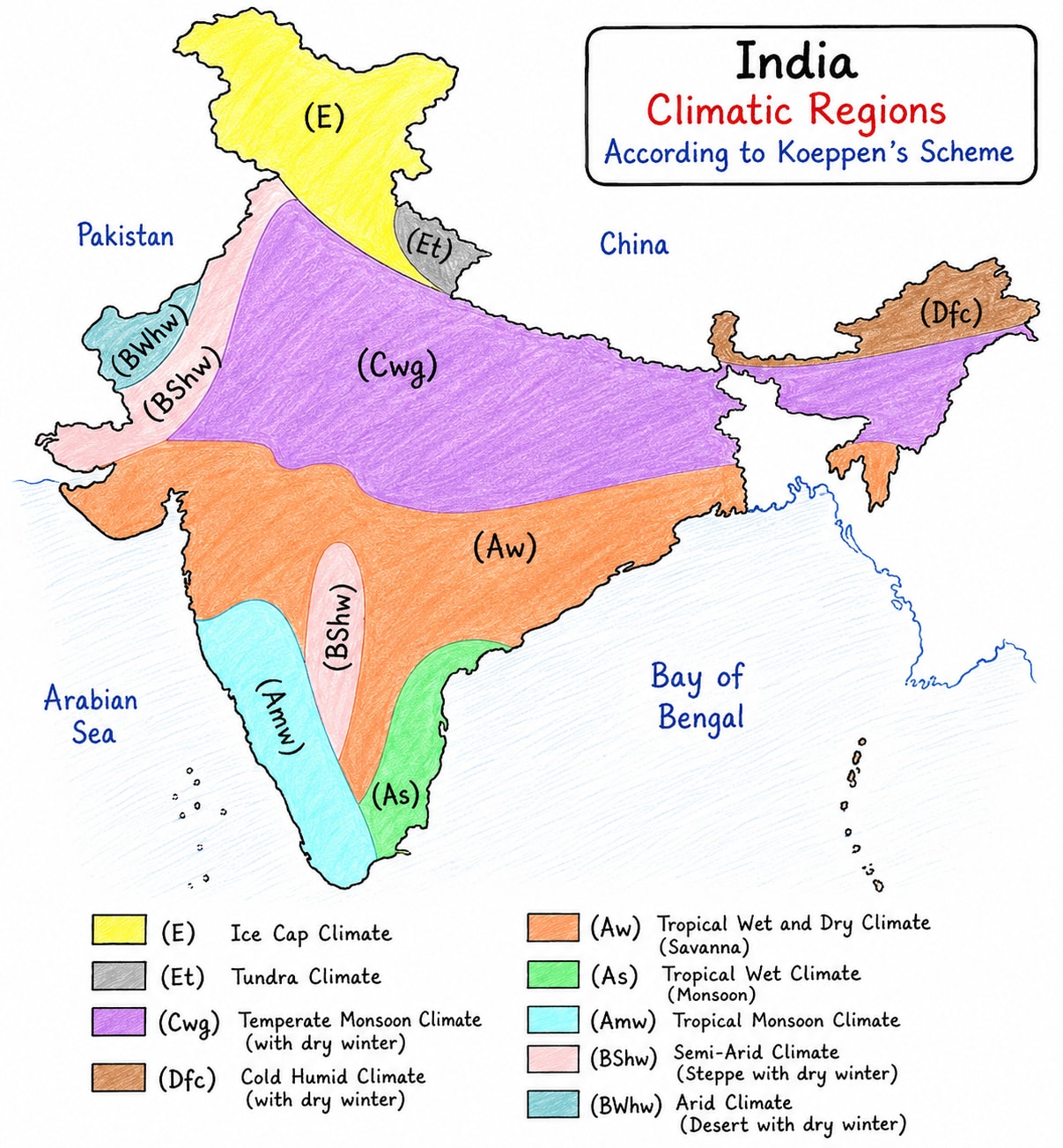
Thus as per Koepen classification India has variety of climatic regions which include Am, Aw, Cwg, BSh, Dfc, Et, etc.
Vegetation Cover
As per data more than 23% area is under forest cover. Forest provide good amount of humus and also control soil erosion.
Time
It is very dominant factor because to make only one centimetre thick soil it take more than thousand year.
Soil Types in India
Alluvial Soil
Alluvial soil is the most widespread and agriculturally important soil. It is formed by the deposition of sediments brought by rivers. It is categorized into
It is found in North-Indian plain, peninsular river valleys and the costal plains of India.
Physical characteristics are
Its texture is sandy to clay.
It is highly porous thus excellent moisture retention.
Mineral composition are
It is rich in lime, phosphoric acid, silica, potash and iron.
It is deficient in nitrogen, humus, phosphorous, zinc, boron and sulfur.
It is suitable for all crops.
Black Soil
It is formed mainly from weathering of Deccan trap Basaltic lava.
It if famous as cotton soil or regur soil.
Its black colour is due to presence of titaniferous magnetite.
Its particle size is very fine because it was formed out of weathering basaltic lava that's why water retention capacity is very high.
It become sticky when wet and hard when dry. This process is called self blowing effect also.
It is found in Maharashtra, Madhya Pradesh, Gujrat, Andhra Pradesh, Karnataka, Telangana, Chhattisgarh.
Physical characteristics are
Its texture is clayed and fine grain.
It is rich montmorillonite clay minerals that's why it swell up and shrinks when it is wet and dry respectively.
Mineral composition are
It is rich in lime, iron, magnesium, aluminium and potash.
It is deficient in nitrogen, phosphorous, organic matter (humus), sulfur, zinc and boron.
It is used for cotton, sugarcane, soyabean, tobacco, sunflower, maze, wheat, jawar, bajara, tur, gram, etc. oilseeds, horticulture, etc.
Wherever intensive agriculture is done soil faces deficiency of zinc and boron
Red soil
It derived its red colour from ferric oxide as well as high diffusion of red colour.
In those areas where rainfall is relatively high its colour become yellow.
It is found in Tamil Naidu, Andhra Pradesh, Karnataka, Telangana, Odisha, Chhattisgarh, Jharkhand, Madhya Pradesh, Southern Rajasthan, Northern West Bengal.
Physical characteristics are
Its texture is sandy to clay.
Porosity is high that's why its water holding capacity is low.
Mineral composition are
It is rich in iron, potash and silica.
It is deficient in nitrogen, phosphorus, humus, lime, magnesium, zinc.
In this depending upon availability of water all types of crops are grown like rice, millet, maze, pluses, oilseeds, cotton, tobacco, sugarcane and horticulture,
Laterite Soil
Laterite soil is a residual soil formed under high temperature and heavy rainfall through the process of laterization.
It is end product of intense weathering in tropical humid conditions where rainfall is more than 200 cm, temperature is high.
It is found in Western Ghats, Eastern Ghats, North-East India, parts of Chhattisgarh and Jharkhand.
Mineral composition
It is rich in iron oxide and aluminium oxide.
It is deficient in nitrogen, potassium, phosphorus and silica.
It is mostly used for plantation crops like tea, coffee, rubber, coconut, cashew, species like pepper, cardamom, horticulture like pineapple, banana, etc.
On pH scale it is acidic
It has poor moisture retention capacity.
Sandy Soil
Sandy soil is outcome of the mechanical weathering in rocks specially in hot deserts and cold deserts where rainfall is less than 50 cm per annum and rate of evaporation is high.
It is found in Thar desert of Rajasthan, Kutch and Saurashtra region of Gujrat, western Haryana and south-west Punjab.
Its colour are light brown to yellowish. It is brown where water is less and yellowish where water is more.
It permeability is very high that is why water holding capacity is very low.
Mineral composition.
Soluble salts, lime, phosphates
It is deficient in nitrogen, humus, zinc and iron.
It is suitable for wheat, mustard, cotton, horticulture like bear, dateplam, kinnow.
Mountain Soil
It develop in hilly and mountainous regions under the influence of altitude.
These are generally sallow and acidic on pH scale.
These are found in Himalayan region, Western Ghats and Eastern Ghats.
Its colour is dark to dark brown.
It is rich in humus but highly susceptible to erosion.
It is rich in organic matter and nitrogen and deficient in phosphorous, potash and lime.
It is mostly used for forests, plantation crops like Tea, coffee, rubber, horticulture like apple, peach, kiwi, cherry, walnut, spices like cardamom, black prepper and food crops like maze, barley, potato, etc.
Bog soil / Peaty and Marshy soil
These are formed in water logged conditions where oxygen is deficient.
The dead plant remains are decomposed only partially that's why organic matter accumulates.
These are found in high rainfall areas where there is poor drainage, water logging.
Distribution is lake areas, swampy areas, wet lands, etc.
Their colour is dark brown to black and acidic on pH scale.
These are rich in organic carbon, humus and nitrogen.
These are deficient in potash, phosphorous and lime/calcium.
These have high biological importance however rice, jute are grown in feasible areas.
Saline and Alkaline Soil
These are problem soils characterized by accumulation of soluble salts or sodium in the root zone.
In India it covers about 6 to 7 million hectors.
Naturally such soil occurs in low rainfall areas but present human induced causes are major concern which includes excessive irrigation, water logging and poor drainage.
It is found Punjab, Haryana, Western Uttar Pradesh, Tamil Naidu, Andhra, etc.
In north India it also called Reh, Kallar, Usar, Tuher, etc.
The top layer of the soil becomes hard and dry which does not allow infiltration of water easily.
On pH scale these are sometime more than 8.5
These are rich in sodium chloride, sodium sulphate, sodium carbonate and calcium and magnesium salts.
These are deficient in nitrogen, organic matter, iron and zinc and phosphorous.
After reclamation it is used for rice, barley, wheat, oilseeds, fodder (All salt tolerant crops.)
Gypsum application is done to treat soil
Soil Profile
Soil profile is a vertical section of soil that shows it different layers called soil horizon, from the surface down to the bed rock. It includes:-
O Horizon
It contains dead leaf, plant remain and humus. However, this organic layer is not necessarily found in every soil.
A Horizon
It is top soil. It is rich in organic matters and minerals. Most plants roots and soil organisms found here.
E Horizon
It is eluviation layer. It is light coloured layer where clay, iron and alluvial have be leased down.
B Horizon
Layer of sub-soil. It is zone of illuviation. In this iron and other minerals which were washed down from upper layers are accumulated.
C Horizon
It is parent material. It is partially weathered rocks and mineral fragments.
R Horizon
It is parent rock or bed rock which is still hard and un-weathered.
A soil profile helps in understanding soil formation, fertility, drainage and suitability for the agriculture and construction.
Soil Erosion
Soil erosion is the detachment, transportation and removal of fertile rock soil by natural agents such as water, wind, sea waves, glaciers or by human activities.
It reduces soil fertility, agriculture productivity and ecological stability. India looses million of tons of top soil every year making soil erosion a major environmental challenge.
Causes of Soil Erosion
Natural Causes
Water Erosion
Water erosion is done by heavy rain, flash flood, river bank erosion or cloud burst.
Wind erosion
It is very effective in arid and semi arid regions e.g. Thar desert.
Glacier erosion
In high altitude or in high latitudes.
Sea wave erosion
In coastal areas e.g. Odisha and Kerala coast.
Human causes
Deforestation
Over grazing
Shifting agriculture
Mining and Quarrying
Unscientific agriculture practices
Over irrigation
Urbanization and infrastructure development.
Types of Erosion
Water Erosion
Splash erosion
Raindrops dislodge soil particles. High terminal velocity causes high splash erosion.
Sheet erosion
Uniform removal of thin layer of top soil over large area.
Rill erosion
Small channels/rills are formed by running water.
Gully erosion
Rill enlarges into deep gullies and gradually in ravines e.g. Chambal ravine in Madhya Pradesh, Uttar Pradesh and Rajasthan.
Wind Erosion
Suspension
Fine dust carried over long distances.
Saltation
Medium size particles bounce along the ground.
Surface creep
Large particles rolls along the surface.
Impact of Soil erosion
Loss of fertile top soil
Decline in crop productivity
Siltation of rivers and reservoirs.
Floods and landslides.
Desertification
Loss of biodiversity
Reduce groundwater recharge.
Global warming (due to released of trapped carbon dioxide).
Conservation agriculture and sustainable agriculture
Dryland farming.
Initiatives taken by GoI to check soil erosion
Integrated Watershed Management Program
Soil and water conservation through check dams, contour bunding, farm bonds and gully ploughing.
Now it is integrated under watershed development component of Pradhan Mantri Krishi Sinchayee Yojana (PMKSY).
Pradhan Mantri Krishi Sinchayee Yojana (PMKSY)
Promote per drop more crop.
Encourage micro irrigation and reduces runoff soil erosion.
National Mission for Sustainable Agriculture
Promotes conservation agriculture, agro-forestry and climate resilient farming.
National Afforestation Program and Green Indian Mission
Afforestation and restoration of degraded forest to stabilize slopes and reduce erosion.
VB–G RAM G
Construction of check dams, contour trenches, fields bunds and water harvesting structures.
Deforestation
National Action Program under the UN convection to combat desertification (UNCCT).
India has committed to achieving Land Degradation Neutrality (LDN) by 2030.
Soil Health card Scheme
Promotes balance fertilizers use and improves soil quality.
National Mission for clean Ganga
River bank protection, afforestation and flood plain management to reduce river bank erosion.
Monsoon
Monsoon is periodic wind system which reverses its direction after certain time. In India its direction south-west to north-east for 90 days and from north-east to south-west for 90 days. The word "monsoon" is derived from Arabic "Mausin".
Classical theory of Origin of Monsoon
The classical theory of Indian monsoon also known as thermal theory was proposed by Edmund Hally in 1688. It explains monsoon as a seasonal reversal of winds caused by the differential heating and cooling of land and sea.
Basic Principles
Land heats up and cools down faster than the ocean due to difference in specific heat.
This creates seasonal pressure differences.
Wind always blows from high pressure to low pressure area.
Mechanism of Summer Monsson (June to September)
Formation of low pressure over land
During summer the Indian landmass becomes intensely heated.
A low pressure area develops over north-western India and adjoining Pakistan.
High pressure over Indian Ocean
The Indian oceans remains comparatively cooler.
A high pressure area develop over Indian Ocean.
Moisture loden wind
Wind blows from ocean towards the land.
While crossing Indian Ocean they absorb large amount of moisture.
Heavy Rainfall
On reaching India these moisture loden wind rise due to Western Ghats and Himalayas orographic rain and conduction rain due to high surface heating. This result in widespread rainfall.
Mechanism of Winter Monsoon (October to February)
During winter lands cools rapidly.
A high pressure area form over northern India.
The ocean remains relatively warmer and crating low pressure area.
Wind reverses direction and blow from land to sea.
These are dry winds thud do not cause rainfall by enlarge but wind blowing over Bay of Bengal cause rainfall over Tamil Naidu.
Limitations of this theory
Doesn't explain role of ITCZ.
Unable to explain monsoon burst, monsoon break, failure of monsoon.
Ignore the influence of Tibet plateau.
Ignore the variation in the distribution of rainfall, etc.
However, it helps understand basic mechanism of summer and winter monsoon that's why it forms the foundation for the later monsoon theories.
Dynamic theory of Monsoon
Dynamic theory of monsoon is also known as Modern theory of monsoon. It explained Indian monsoon as global atmospheric circulation of atmospheric rather than differential heating of land and sea as suggested by classical theory.
It highlights the role of ITCZ, Tibet Plateau, jet streams and ocean atmosphere interaction.
Basic Theory
The Indian monsoon is part of global wind circulation system.
Its onset, intensity and withdrawal are controlled by seasonal migration of pressure belts and upper air circulation.
Role of ITCZ
During summers the ITCZ shifts northward to the Indo-Gangetic plains.
It creates a low pressure belt over North-Indian plain.
Moisture loden wind from southern Indian Ocean cross the equator and turn rightward due to Coriolis force and reach the Indian Subcontinent as south-west monsoon and stays over India between June to first week of September.
North-East Monsoon
With the onset of winter season or with apparent equatorward movement of sun from Tropic of Cancer and thereafter its movement towards Tropic of Capricorn ITCZ is also started shifting equatorward thus the direction of wind reverses and first week of September it starts moving/blowing from Indian Subcontinent to the ocean and the direction of wind is north-east to south-west that's why it is called North-East Monsoon.
Factors responsible for strengthening of Indian South-West Monsoon
Heating of Tibet Plateau
Strengthening of Mascarene High
Tropical Easterly Jet (TEJ)
Somali Jet
Positive Indian Ocean Dipole
Active phase of Madden Julian Oscillation (MJO) on Indian Ocean during South-West Monsoon
La-Nina phase of ENSO
Factors responsible for weakening of South-West Monsoon
Poor heating of Tiber Plateau
Delayed northward (north to Himalayas) shifting sub-tropical westerly Jetstream
Negative Indian Ocean Dipole
Passive phase of Madden Julian Oscillation over Indian South-West Monsoon
El-Nino phase of ENSO
EN-Nino phase of
Role of Tibet Plateau heating in Indian Monsoon
Tibet Plateau with an average elevation of 4500 to 5000m is often called the heat engine or elevated heat source of Asia. During summers its intense heating plays a crucial role in strengthening the South-West Monsoon by influencing both surface pressure and upper air circulation.
Mechanism
Intense Heating of the Plateau
During May to June Tibet Plateau receives intense solar radiation.
Being at high altitude it heats the surrounding atmosphere efficiently.
Warm air rises, creating a deep thermal low over the plateau.
Formation of upper air low pressure
Rising warm air causes low pressure over Tibet.
This creates strong upward motion over Tibet
Strengthening of Indian low pressure System
The thermal low over Tibet combines with the surface low over north-west India.
This intensifies the continental low pressure system increasing the land-sea pressure gradient.
Strong cross equatorial flow
The increased pressure gradient draws strong south-east trade winds across the equator (Trade winds of southern hemisphere).
After crossing the equator these are deflected rightward by the Coriolis force and become the south-west monsoon winds.
Development of Tropical Easterly Jet
The heating of Tibet Plateau contributes to the Tropical Easterly Jet in upper atmosphere between 10° to 15° N latitude and between south-east Asia to Africa.
The TEJ enhances upper layer divergence which supports strong convection and monsoon rainfall.
Strengthening of Mascarene High
Although the Mascarene High is not created by Tibet Plateau but it strengthening is done by the descending air which comes form Tibet.
In the higher troposphere of Tibet anti-cyclonic condition are develop from where wind diverges toward equator and after crossing the equator it descends over southern Indian Ocean, Mascarene High.
Strengthening of Mascarene High further intensifies PGF (pressure gradient force) between Indian Subcontinent and sea.
Surface wind blows towards equator and thereafter towards Indian Subcontinent and it creates a positive feedback and this cellular motion of the wind is called Koteswaram Cell.
What if Tibet Plateau not heated properly?
It leads to poor monsoon because
PGF between land and sea is poor
Weak Mascarene High
Weak Tropical Easterly Jet
Weak Somali Jet as it is outcome of strong Mascarene High
Sometime northward shifting of sub-tropical Westerly Jetstream is also delayed.
Somali Jet
It is a strong low level Jetstream at the altitude of 1 to 1.5km. It blows along with eastern coat of Africa and after crossing equator it turns rightward to reach Indian Subcontinent.
Mechanism of formation
Strong Pressure Gradient
Mascarene High develops strong high pressure.
At the same time there is thermal low over north-west India and Tibet plateau.
Cross Equatorial Flow
Air naturally moves from high pressure to low pressure.
South-East Trade winds cross the equator.
Coriolis Force
After crossing into northern hemisphere the winds are deflected to the right.
The south-east trade become south-west trade wind or south-west monsoon.
Channelling along Somalia
The east African highlands guide and accelerates these winds along the Somalia coast.
This produces a narrow fast moving air current called Somali Jet.
The powerful Somali Jet blowing at the altitude of 1 to 1.5km blows over Arabian Sea to reach over Indian Subcontinent and influences the winds to absorb more moisture and cause good rain over India.
Indian Ocean Dipole
Indian Ocean Dipole is an ocean atmosphere coupled phenomena characterized by the difference in sea surface temperature between the western equatorial Indian Ocean near east Africa and eastern equatorial Indian Ocean near Indonesia. It was first described by NH Saji and independently by Toshio Yamagata in 1999.
Mechanism of IOD
Normal Condition
SST (sea-surface temperature) is warmer near Indonesia than near east Africa. Warm water causes low pressure and rising air over Indonesia whereas cooler western Indian Ocean has relatively high pressure. The surface wind blows from west to east maintain the warm pool of water in eastern Indian Ocean.
Positive IOD
SST becomes warmer in the western Indian Ocean
SST becomes cooler near Indonesia due to strong upwelling.
Low pressure shift towards east Africa.
Rising air occurs over the western Indian Ocean.
Sinking air develops over Indonesia.
Surface winds weakens along the equator.
Impact on India
Stronger southwest monsoon because it absorb more moisture. It receives normal to above normal rainfall in many parts.
Negative IOD
Eastern Indian Ocean becomes warmer than normal.
Western Indian Ocean become cooler.
Strong convection develops near Indonesia.
Air sinks over the western Indian Ocean
Moisture transported towards India is weakened.
Impact on India
Weak southwest monsoon reduce rainfall and increase risk of drought.
It mostly associated with El-Nino
Madden Julian Oscillation
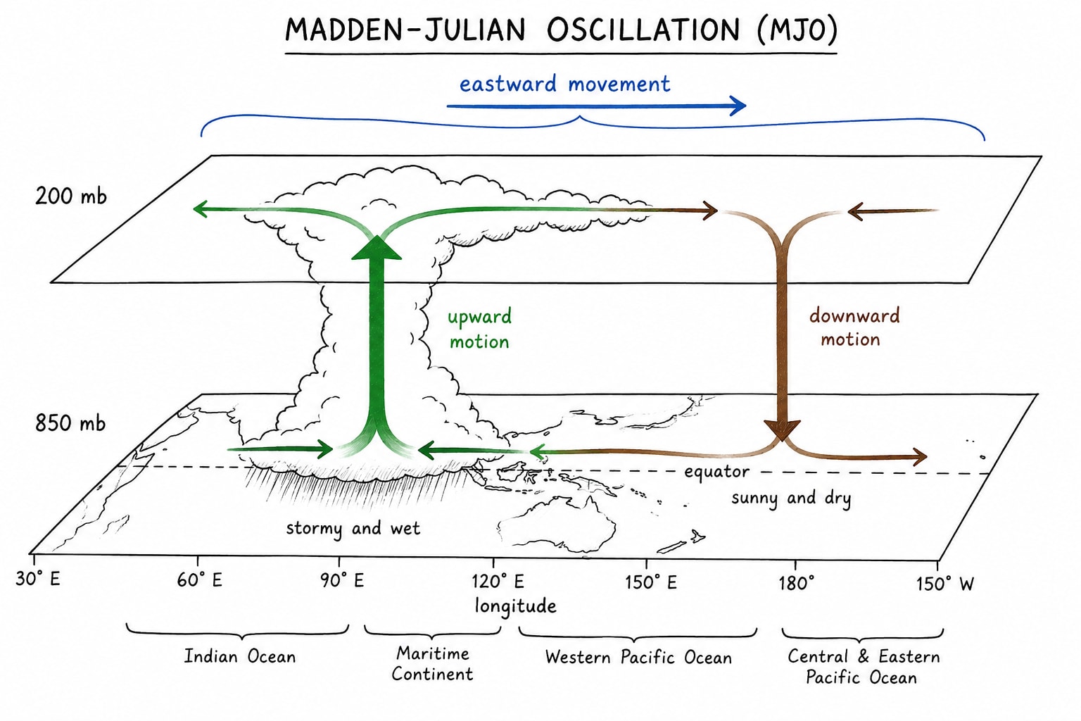
MJO is important circulation which is found over equator. It is eastward moving disturbance of tropical clouds, rainfall, winds and pressure that travel around the Globe near equator. It was discovered by Rolt Madden and Paul Julian in 1971.
Basic Structure of MJO
MJO consists of two parts:-
Active Phase/Convection
Warm and moist air rises
Deep cumulonimbus clouds develop
Heavy rainfall occurs
Strong convection
Suppressed Phase
Air sinks/subsides
High pressure develop
Cloud formation decreases
Dry weather prevails
Mechanism of MJO
Warm Ocean Surface
Tropical ocean receives intense solar heating.
Sea surface temperature exceeds about 28°C, supplying abundant moisture.
Formation of Deep Convection
Moist air rises up
Condensation releases latent heat
A large convection cloud cluster develops
Upper Level Divergence
Rising air spreads outward in upper troposphere
It strengthens the convection
Eastward Movement
Atmospheric waves and wind interaction shift the convection system eastward across the tropics
Suppresses Phase Follows
Behind every active phase there is suppressed phase.
Cloud formation decreases rainfall decreases.
How does MJO influence Southwest Monsoon?
MJO control active and break in monsoon
Active phase over Indian Ocean causes strong convection and strengthening of low pressure thus moisture transfer increases and widespread rainfall occurs across India.
While, suppressed phase over Indian Ocean is dominated by descending air thus poor rainfall. It causes "Break Monsoon" conditions.
During the active phase Northern Indian phase become highly convective specially Bay of Bengal thus more low pressure system thus monsoon depression are formed. We know that monsoon rain in India is directly proportional to number of depression.
Active phase of MJO strengthens cross equatorial winds, intensifies Somali Jet and increases moisture transport to the Northern Indian Ocean.
Active phase of MJO pushes monsoon winds to reach India in advance/before date. e.g. 2025 monsoon reached India (Kerala) in May 6 days in advance.
If in the suppress phase during onset of monsoon over Indian Ocean then the onset of monsoon is delayed.
Southern Oscillation
The southern oscillation is see-saw pattern of atmosphere pressure between Eastern Pacific (Tahiti) and Western Pacific (Darwin of Australia). It is one of two components of ENSO i.e. EL-Niño Southern Oscillation phenomenon and the other begin changes in the sea surface temperature (El-Nino and La-Nina).
Mechanism
Normal condition
Pressure over Tahiti is high
Pressure over Darwin is low
Strong trade wind blows from east to west
Warm water accumulates near Indonesia and northern Australia.
Strong convection and rainfall occur over Western Pacific.
Cold water upwelling occurs off Peru and Ecuador result normal and good monsoon.
Positive Southern Oscillation (La-Nina)
Pressure over Tahiti increases
Pressure over Darwin decreases
Trade wind become much stronger
Warm water is pushed further west
Strong convection over Indonesia and nearby regions.
Impact on India
Generally stronger and more than normal rainfall
Sometime it become excess rainfall.
Negative Southern Oscillation (El-Nino)
Pressure over Tahiti decreases
Pressure over Darwin increases
Trade winds become weak
Warm water shifts eastward toward Peru
Convection moves to eastern Pacific (sometimes up to Central Pacific)
Impact on India
Weak Southwest Monsoon
High probability of drought
Reduce agricultural production
Increased heatwaves
El-Nino Modoki
El-Nino Modoki is type of El-Nino in which the maximum sea surface temperature warming occurs in the North Central Pacific instead of Equatorial Pacific near Peru or Ecuador which happen in the typical classical El-Nino.
The word "Modoki" is a Japanese word which means "Similar but different". It was introduced by Japanese meteorologist and climatologist Toshio Yamagata in 2007
Mechanism
Warm sea surface temperature in the Central Equatorial Pacific.
The Eastern Pacific remains relatively cool.
Rising air and deep convection shifts to the Central Pacific instead of the Eastern Pacific. It creates tripolar sea surface temperature patter:-
Cool temperature in the Western Pacific
Cool temperature in the Eastern Pacific
Warm temperature in the Central Pacific
Thus water circulation become spilt into two circulation cell i.e. convection rises from Central Pacific down on the Western and Eastern Pacific.
Impact on India
It weakens Southwest Monsoon but not always
The impact depends strongly on the behaviour of IOD and MJO.
Southwest Monsoon
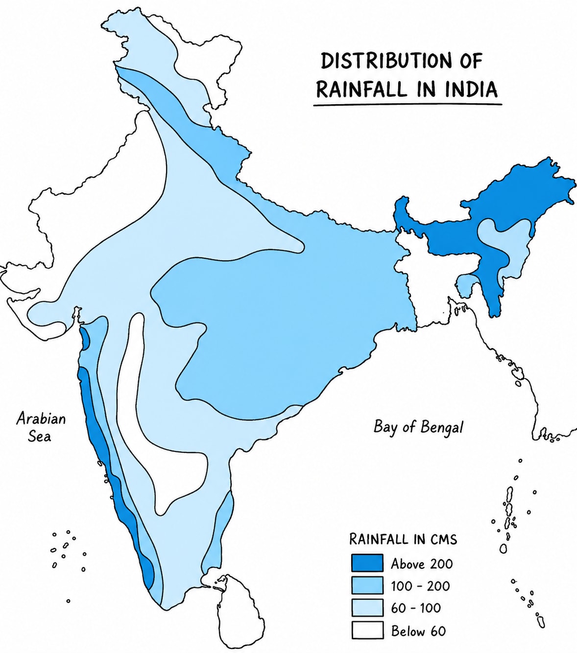
The southwest monsoon is a large scale seasonal wind system that brings about 75 to 80% India's annual rainfall during June to September. It is governed by the interaction of land-sea thermal contrast, seasonal migration of pressure belts, shifting of ITCZ, heating of Tibet Plateau, Jetstream, ENSO, IOD and MJO.
Mechanism of Origin
During summer season strong low pressure area develop over Northwest India where atmosphere pressure falls up to 994 to 996 mb whereas, high pressure remains over Southern Indian Ocean i.e. 1020 to 1025 mb or hPa.
Besides this due to apparent northward shifting of sun ITCZ also shifted northward as monsoon trough. This ITCZ attracts trade winds of southern hemisphere to cross equator. After crossing the equator it is deflected rightward by Coriolis forces and reaches over Indian Subcontinent.
However while blowing over Northern Indian Ocean it is divided into two branches
Arabian Sea Branch
Bay of Bengal Branch
Arabian Sea Branch
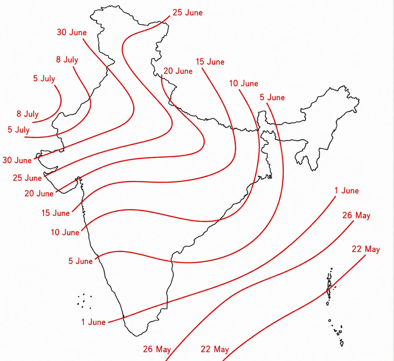
Arabian sea branch reaches to Kerala first and make first monsoon rain over there on 1st June.
Rain occurs along with western slope of western Ghats. The eastern slope falls in rain shadow area.
By 5th June it reaches to coastal Karnataka and by 10th June to Mumbai. This way entire western coast receives good rainfall by 10th June.
Thereafter, this monsoon branch enter in Narmada and Tapi rift valley and goes deep inside to Madhya Pradesh.
By 15th June it rains entire Gujrat and moves northward to rain over Rajasthan.
In Rajasthan eastern part receives good rain but western part does not because:-
Monsoon wind blow parallel to Aravalli
Condition of temperate inversion prevailing over Western Rajasthan, deserts.
By 20thJune it reaches to Delhi, Haryana plain where it joined by Bay of Bengal branch by 15thJuly entire India covered.
Bay of Bengal Branch
Bay of Bengal branch is stronger than Arabian Sea branch because
Average temperature of Bay of Bengal is higher than Arabian Sea
Monsoon winds blow for a longer duration over Bay of Bengal before they hit continents thus have high amount of moisture.
Bay of Bengal branch brings first monsoon rain India between 20th to 25th May on Andaman and Nicobar island.
By 5thJune it covers Northeast India.
By 10th June covers Telangana, Odisha, West Bengal and Andhra Pradesh.
By 15th June Chhattisgarh, Bihar, Jharkhand, Eastern Uttar Pradesh.
By 20thJune Central India, Madhya Pradesh, Jharkhand, Western Uttar Pradesh.
By 25thJune it joins Arabian Sea branch in Delhi-Haryana-Punjab plains.
By 15thJuly entire India is covered.
It keep raining over India up to first week of September. Thereafter, it start retracting.
Northeast Monsoon
Northeast monsoon also called retracting monsoon is a seasonal reversal of winds that occurs from September to December first week. It blows from land to the sea thus it does not rain except Tamil Naidu where it rains because moisture it absorb from Bay of Bengal.
Mechanism
By late September, the sun appears to move south to equator.
The Indian landmass begin to cool rapidly. At the same time Arabian sea and Bay of Bengal start getting warmer.
ITCZ start shifting southward thus wind direction become northeast to southwest and it blows from land to the sea.
Only some par to the northeast wind which blows over Bay of Bengal receives good amount of moisture and rains over Tamil Naidu and some parts of Andhra Pradesh like Nellore, Tirupati, etc.
By the first week of December northeast monsoon leaves India.
Rainfall Distribution in India
The distribution of rainfall in India is mainly influenced by Southwest Monsoon i.e. June to September, Northeast Monsoon specially in Tamil Naidu, westerly disturbances and tropical cyclones which occur mainly in coastal areas. The average rainfall in India is 110 cm per annum. However, the rainfall distribution in India has high spatial and temporal variations.
Distribution of Rainfall
Volume
Region
Very Heavy Rainfall
above 200 cm annually
Western Ghats - Kerala, Karnataka, Goa, Maharashtra (costal areas)
Northeast states (Meghalaya, Assam, Arunachal Pradesh, Sikkim) and West Bengal
Foothills of Himalaya
Moderate Rainfall
100 to 200 cm
Eastern India - West Bengal, Odisha, parts of Bihar, Jharkhand, Chhattisgarh
Eastern Coastal Plain
Low Rainfall
50 to 100 cm
Central India (Madhya Pradesh), interior of Maharashtra (eastern part), Telangana, Karnataka, Andhra and Tamil Naidu
Scanty Rainfall
below 50 cm
Thar Desert, Western Rajasthan, parts of Gujrat (Kutch region)
Cold desert areas of Ladakh
Mawsynram receives the highest annual rainfall in India. Basically two places or region receives rainfall more than 300 cm per annum other is Meghalaya (Khasi Hills)
Factors Affecting Rainfall distribution
Direction and strength of monsoon winds.
Relief features such as Himalayas and Western Ghats.
Large geographical area of country which strongly creates effect of continentality.
Variation in the local temperature and local pressure gradient.
Besides this regional/ spatial variation there is temporal variation also in the distribution of rainfall because India receives its 70 to 80% rain between June to September only.
Westerly disturbances remain confined to the winter season and only North Indian Plain.
Pre and Post Monsoon tropical cyclones effect only coastal areas.
Rainfall Variability
Rainfall variability refers to year to year fluctuations in the amount of rainfall receives at a place compared with its long term average. It is expressed as coefficient variability or CV
CV =
If the value of CV is low it means rainfall is reliable and uniform.
If the value of CV is high rainfall is erratic and uncertain.
Spatial Pattern of Rainfall Variability in India
Region
Variability(%)
Western Rajasthan, Kutch of Gujrat, Ladakh
40 to 60
Interior Deccan Plateau (Maharashtra, Karnataka, Telangana, Western Andhra)
20 to 40
Indo-Gangetic Plains
15 to 25
Western Ghats and Northeast India
Below 15
Why Does Rainfall Variability Differ?
Amount of Rainfall
Areas with high average rainfall generally have low variability e.g. Northeast India.
Areas with low average rainfall generally have high variability e.g. Western Rajasthan.
Monsoon Dependence
Regions depending on few monsoon events show greater fluctuations e.g. Western Rajasthan and Punjab.
Relief
Region with high relief receives consistent orographic rainfall e.g. Western Ghats and Himalayas.
Dependency of monsoon on various climatic phenomena like IOD, MJO, El-Nino, etc.
Importance of Rainfall Variability
High variability increases the risk of droughts and crop failure.
It affects food security.
It exerts heavy pressure on groundwater resources.
It highlights the need for irrigation, crop diversification, watershed management and climate resilient agriculture.
Koppen's Classification of Climate of India
The Koppen climate classification classifies climate based on the relationship between temperature, precipitation, natural vegetation. It is one of the most widely used climate classification system and it is important to understand India's climatic diversity. The major Koopen types in India are
Koppen Classification
Features
Region
Amw
Tropical monsoon with rainfall in summer season (winter dry)
Western Ghats western coast
As
Tropical summer dry, rainfall during winters
Tamil Naidu
Bshw
Warm and semi arid (steppe)
Rain shadow area of Western Ghats and Western Rajasthan
Aw
Tropical Monsoon
Rest of the Peninsular India
Cwg
Humid sub-tropical dry winter
Gangetic Plain
Bwhw
Hot desert
Thar Desert
E
Cold region
Ladakh
ET/Et
Tundra
Uttarakhand
Dfc
Temperate with high rain
Sikkim, Arunachal, Mizoram, Tripura
Merits of Koepen's Classification
Objective and scientific classification based on measurable climate data.
Useful for studying vegetation, agriculture, and climate change.
Enable comparison of climates across different regions of the world.
Limitations of Koepen's Classification
Does not adequately explain India's monsoon dynamics.
Local influences such as altitude aspect and western disturbances are not fully captured.
Climatic transition are gradual whereas the classification uses fixed boundaries where which not realistic.