Comprehensive Oceanography notes for UPSC Geography. Detailed study of ocean bottom topography, continental shelf, salinity, ocean currents, and tides.
Ocean Bottom Topography
Continental Shelf
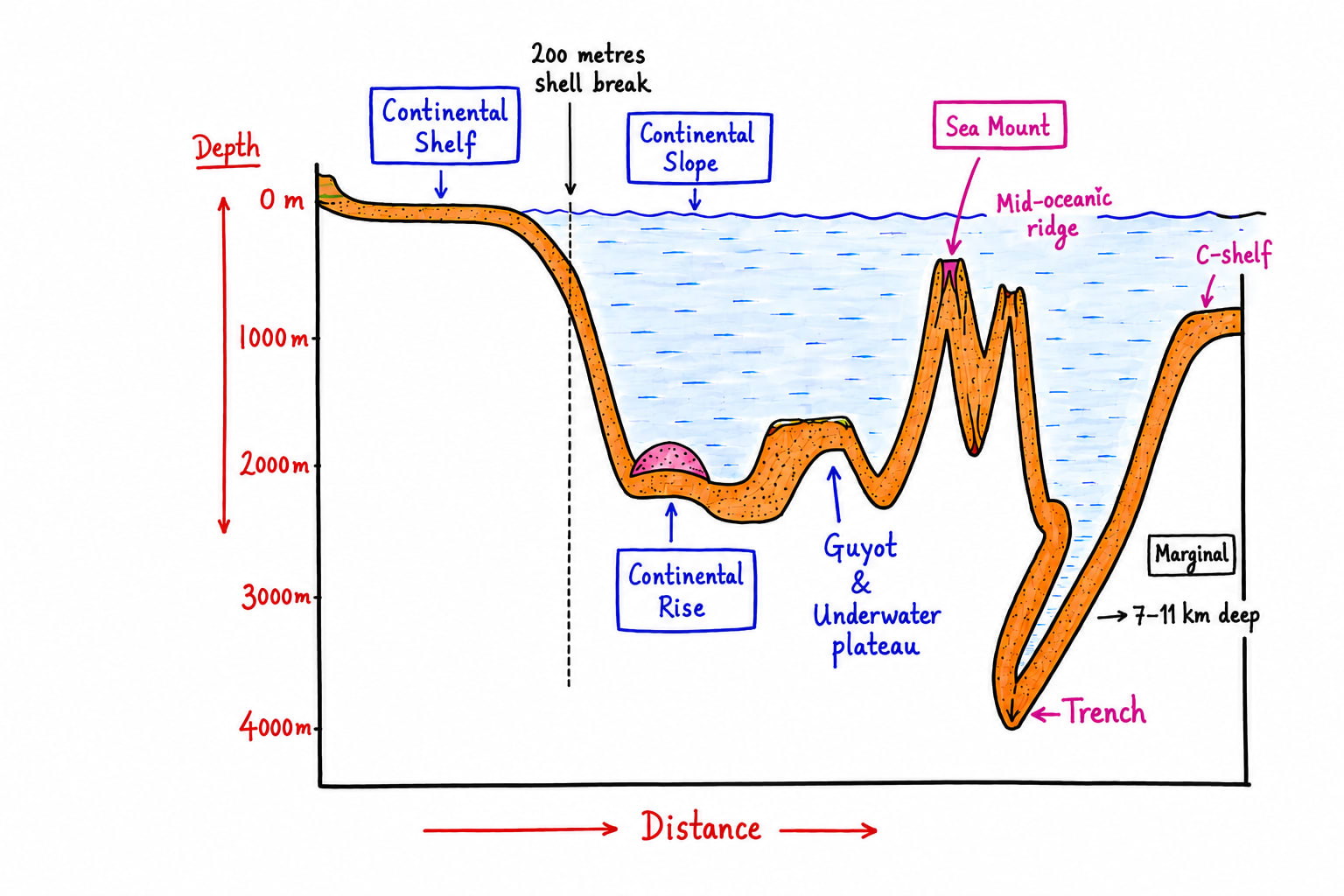
Continental shelf are extension of continents into the sea. It extends up to the depth of 200m. Its last limit is shelf break.
Importance
Rich in biotic resources like fisheries. It is because
Due to sallow depth, it absorbs abundant sunlight
Photosynthesis take place up to the depth of 200m.
It is abundant amount of dissolved oxygen.
It is important region where cold and warm ocean currents meet, which makes the temperature ideal for the growth of phytoplankton's which make the base of marine food chain.
Rich in fossil fuel resources.
The larger concentration of fossil fuel resources in the world is concentrated on continental shelf either of present or of geological past.
The West Asia which has largest oil reserves like in Saudi Arabia, UAE, Quat, Iran, Iraq are on continental shelf. Venezuela of South America (Lake Maracaibo), Libya and Nigeria in Africa, South China Sea in East Asia, Okhotsk Sea in Eastern Russia, Northern Black Sea of Russia and Ukraine, North Sea in West Europe between Norway and UK are prime examples.
Rich in metallic minerals
These are deposited by rivers during their delta and estuary formation.
Very rich in biological diversity
e.g. Mangroves and Corals
Strategic Significance
The sovereignty of a country extends up to 12 nautical miles from the base, contiguous zone up to 12 (24) nautical nautical miles and exclusive economic zone extends up to 200 nautical miles from the base line.
It contributes in maintaining coastal ecosystem like coastal erosion, protection from Tsunami, tropical cyclones, etc.
Growing Importance of Artic Continental Shelf
Because of the growing importance of Artic Continental shelf various resource sharing issues have emerged between the northern countries, countries sharing their coast with Artic. However, for peaceful negotiation and cooperation, execution UNCLOS (United Nation Convection on the Laws of the Seas) Artic Council has formed and India has also been given the status of observer.
Importance of Artic CS
Huge potential of oil and gas
Russia and Norway are engaged in exploration.
Huge potential of rare earth minerals as well as metallic minerals like nickel, cobalt, cooper, etc.
Various high fishing grounds
Melting of glaciers will open new trade routes which will connect Asia, Europe and North America more efficiently.
It is important to study the heat balance of earth.
Why India is interested in Artic CS
To meets its energy security
Import oil and gas from Artic region in future
To study impact of climate change.
To take benefits of new trade routes.
To avail the benefits of geopolitics of the Artic Region.
To make optimum use of blue economy of Artic.
Continental Slope
It extends beyond shelf break towards the seaward side. It is the region of step slop thus the depth could be 3000-4000m
Importance
It makes boundary between continents and the oceans.
It has gad hydrate and other mineral resources.
Influences ocean currents
Many at times epicentre of earthquakes.
Continental Rise
It extends next to continental slope. It is formed due to deposition of the sediments which slide down along with continental slope.
Importance
Great possibility of oil and gas.
Support important marine ecosystem.
These are found mostly along with the coast which has exposure to constructive plate margin.
Ocean Trenches
These are deepest part of the ocean which are formed due to plate convergence. e.g.
Trenches of Pacific Ocean
Mariana Trench
It is situated east to Philippines in North-Western Pacific.
It is deepest trench in the world, has depth of more than 11kms.
Mindanao Trench
It is situated between Philippines and Mariana Trench.
Japan Trench
East to Japan
Kuril Trench
East to Russia
Peru-Chile Trench
West to South America in South-Eastern Pacific.
Tonga Trench
North-east to Austrailia
Trenches of Indian Ocean
Java/Sunda Trench
Deepest of Indian Ocean, depth is more than 7000m.
Trenches of Atlantic Ocean
Puerto Rico Trench
Romanche Trench
These are found along with destructive plate margin
Guyot
These are underwater plateaus, altitude less than 1000m, formed due to the erosion of sea mounts usually. Rich in biodiversity and minerals specially metallic ferrous and non-ferrous.
Sea Mounts
These are volcanic peaks, altitude more than 1000m. These are rich in biodiversity like coral, fishery. It affects ocean currents.
Mid-Oceanic Ridge
These are formed along with divergent plate boundary.
Ocean Temperature
Sources of Temperature
Sun (most important)
Underwater volcanism
Organisms metabolism
Pressure
Water Movement (frictional heat)
Horizontal Distribution of Temperature
It refers to the variation of temperature from one place to another across the earth surface at the same latitude or between different regions.
Factors Affecting Horizontal Distribution of Temperature
Latitude
Temperature generally decreases from equator towards pole.
Land and Water distribution
Open areas have moderate temperature whereas coastal areas have relatively extreme temperature because of the influence of landmass.
Size of the water bodies
In tropical areas small waterbodies have higher temperature than the large water bodies. e.g. Red Sea has high temperature than the Arabian Sea.
Whereas, in high latitudes/ polar region small water bodies have lower temperature than the large water bodies. e.g. Baltic Sea has lower temperature than the North Sea.
Direction of Wind
Offshore winds decrease temperature near the coast and onshore wind increase temperature near the coast due to upwelling and downwelling respectively.
Ocean Currents
Warm Ocean Current Increase temperature and cold ocean current decrease temperature. e.g. Norwegian Current, warm current makes Norway habitable but Labrador Current and East Greenland Current make Greenland example of cold desert.
Vertical Distribution of Temperature
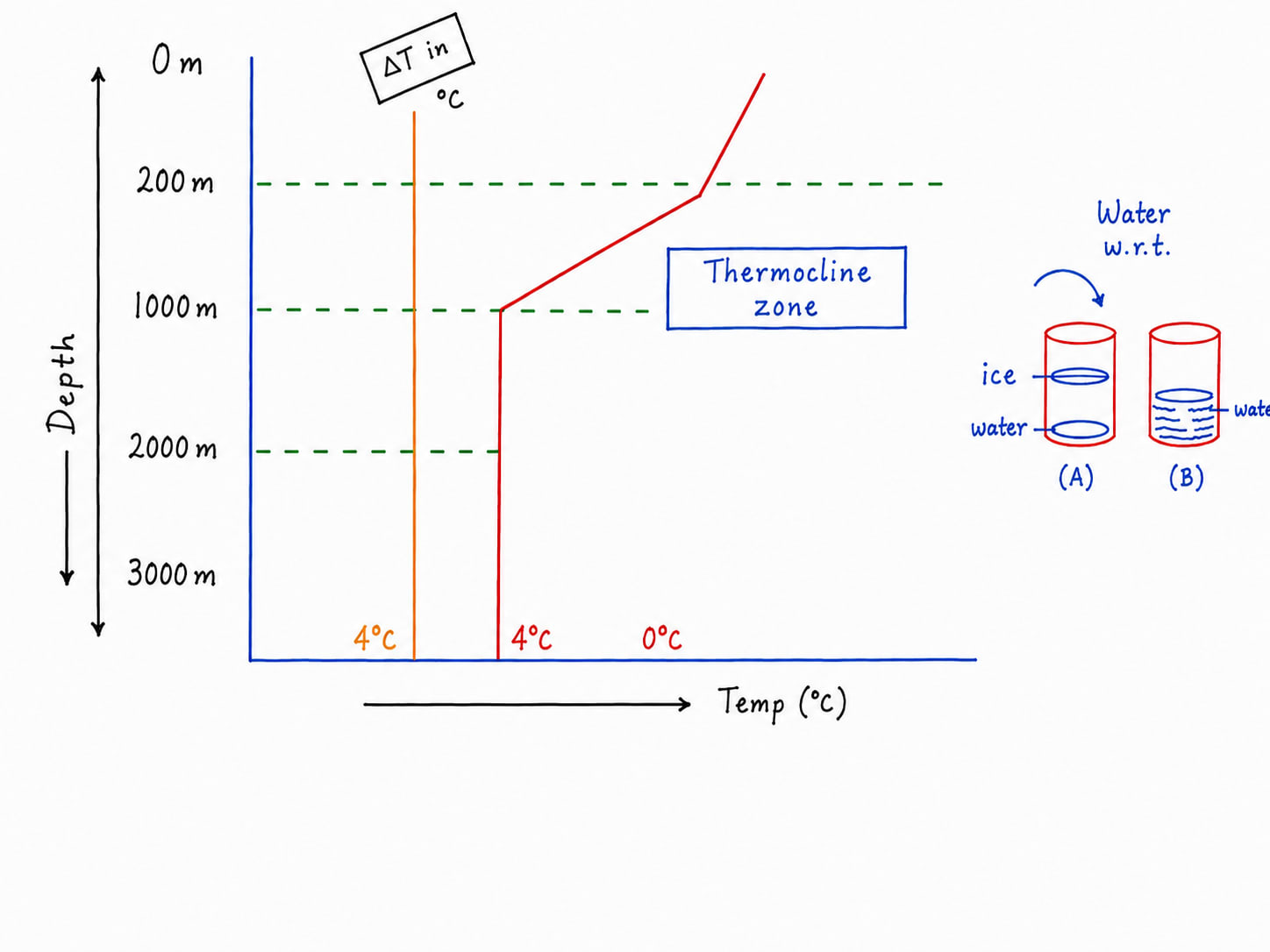
With increasing depth temperature decreases in ocean water but the rate of decrease in temperature is not uniform.
In general, ocean water is broadly divided into three thermal zones.
Surface Mixed layer
It extends up to 200m depth on an average. Here temperature remains high but relatively uniform due to mixing of water caused by wind, waves and currents.
Thermocline Zone
It extends between to 200-1000m in open sea. In this temperature falls with steepest rate.
Deep and Bottom Zone
It extends below 1000m and extends up to bottom. Temperature usually remains 4°C.
Isotherms on Ocean
Ocean Salinity
Ocean salinity is the amount of salts dissolved in given value of water in the ocean. Source of minerals is soil, which is taken into ocean by rivers, glaciers, wind, coastal waves, etc. Salinity of ocean is expressed in amount of salt/minerals per thousand gram of sea/ocean water. Average salinity of ocean is 35 g/1000 or 35°%.
Ocean salinity is the amount of dissolved salt present in the sea water, usually expressed in parts per thousand. The average salinity of worlds ocean is about 35 g/1000 or 35°% i.e. 35of salt per kilogram of seawater.
Major Salts in Seawater
Sodium Chloride
Magnesium Chloride
Magnesium Sulphate
Calcium Sulphate
Potassium Sulphate, etc.
Sources of Salinity in the Ocean
Soil
Soil come from the continents and from the weathering and erosion of ocean bottom.
From the continents it is taken into the sea by rivers (largest source)
Winds
Most effective in coastal deserts
Glaciers
Most effective in high latitudes like Greenland, Russia, Norway, Canada, Antarctica, etc.
Coastal waves.
Factors Affecting Ocean Salinity
Evaporation
Salinity is directly proportional to temperature/rate of evaporation.
Most saline lake in the world is in Antarctica.
Precipitation
It supplies freshwater to the sea because of this lesser salinity is recorded on the equator.
Salinity is inversely proportional to availability of freshwater that includes precipitation, river and melting of glaciers.
River discharge
River water has salinity less than 5 per thousand usually thus, it is discharge of freshwater. That's why near the delta of Ganga, Brahmaputra, Amazon salinity is recorded less.
Melting of glaciers
This is why higher latitudes salinity is less e.g. Baltic Sea.
Direction of Wind
Offshore winds decrease salinity near the coast and support upwelling.
Whereas, onshore wind increase salinity and support downwelling.
Relatively lower salinity is recorded near the equator due to high precipitation.
Maximum salinity is recorded between 20°-30° N and S.
Thereafter salinity keep on decreasing gradually towards the pole.
However, there are some regional variations in the distribution of salinity e.g. Relatively small water bodies in tropical areas have higher salinity than the large water bodies. e.g. Red Sea has high salinity than the Arabian Sea.
Similarly there are various small water bodies which have maximum salinity in the world, which includes
Dongguan Pond Antarctica - 440 per thousand
Gatel Pond Ethiopia - 433 per thousand
Lake Rabeta Senegal - 400 per thousand
Lake Vanda Antarctica - 350 per thousand
Garabogazköl Turkmenistan - 350 per thousand
Dead Sea
Dead sea is situated Israel and Jordan
It has salinity 340 per thousand.
Lake Won Türkiye - 350 per thousand
Great Salt Lake USA - 270 per thousand
Sambhar Lake India - 35 per thousand
Vertical Distribution of Salinity
Vertically ocean water is divided into three layers on the basis of salinity
Surface Layer
It is region of high variability of salinity due to evaporation, precipitation, river discharge, ice formation, melting, etc.
In this salinity starts decreasing gradually with increasing depth in the tropics and temperate region. However, in the polar region salinity increases gradually with increasing depth.
Halocline Zone
In the zone salinity changes rapidly with the depth.
It is a zone of transition between high salinity above and low salinity beneath.
It extends between 200-1000m.
Deep Ocean
Salinity remains uniform beyond 1000m to the sea bottom.
Ocean Dynamics
Waves
Waves are rhythmic rise and fall in the sea water mainly caused by wind. In this water does not move horizontally, it oscillates on its place. In this only energy transfer is done between the water molecules not the displacement. The source of energy is wind. It has two other types Tidal wave and Tsunami Waves.
Tides
Tides are rhythmic or periodic rise and fall of sea level relative to the coast, mainly caused by the gravitational attraction of moon and sun together with earth's rotation. Every place on earth/ocean experiences two tides in a day at the interval of 12 hours 26 minutes.
Forces Responsible for Tide
Gravitational force of moon
It is most important force because gravity is inversely proportional to square of distance.
Sun has maximum gravity but moon is far nearer to earth.
Sun's gravity
Sun has maximum mass and gravity is directly proportional to mass.
Earth's rotation
Because of earth's rotation different parts of the ocean moves through the tidal budge, causing the apparent periodic rise and fall of sea level.
Other local Factors
Shape of coastline
Depth of ocean
Coriolis force, etc.
Types of Tide
Spring tide or High tide
It occurs when sun moon and earth are on 180° plane. This position is called Syzygy position
Neap tide or low tide
It occurs when sun moon and earth are on quadrature position.
Highest tide on occur in Bay of Fundy, Canada.
Tidal bore: A tidal bore is wave or surge of incoming tidal water that travels upstream into the river from the sea. e.g. in Hooghly River, Amazon River, etc.
Importance of Tides
Navigation
e.g. Hooghly Port of India
Tidal Energy
e.g. France, Canada, South Korea, etc. produce amount of tidal energy.
India has maximum tidal energy potential in Gulf of Khambhat.
Fishing
It influences fish migration, benefiting coastal fisheries.
Supports coastal ecosystem e.g. Mangroves.
Tsunami Waves
Tsunami is a high coastal wave with very long wavelength and long ocean period generated by sudden displacement of large volume of seawaters.
Why tsunami become so dangerous near the coast?
In the deep ocean when tsunami waves are formed, the wave height relatively very low that's why a tsunami may passed beneath ship without being notice as a huge wall of water. But when approached close to the coast wave height increases and that might go up to 30m and above. It happens because of the decreasing depth of the oceanwater. It speed could be 700-800km/h that is why hydraulic pressure per unit area becomes massive and this is the root cause of destruction. The other cause of disaster is flood.
Tsunami 2004, where the epicentre was near Indonesia, caused the most sharp destruction and hundreds of km away India and Sri Lanka were badly affected.
Ocean Current
Causes of Ocean Current
Ocean currents are formed due to
Density difference between two places in the ocean water
Temperature difference
Salinity difference
Direction of planetary winds
Coriolis force
Configuration of the coast
Ocean Bottom Relief act as a modifier
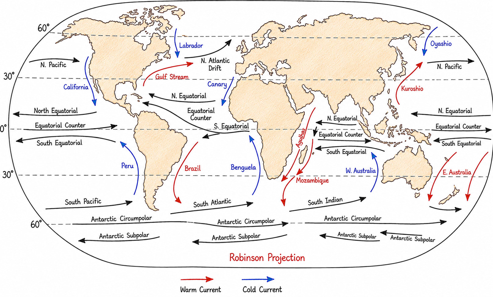
Types of Ocean Current
Warm Ocean Current
Cold Ocean Current
Importance of Ocean Current
Global heat redistribution from tropics to pole and from poles to tropics.
Influence on Rainfall
Warm current support rainfall and cold current negatively affect rainfall.
Fisheries
Whenever warm and cold currents meet, it creates ideal conditions for fisheries growth.
Cold currents are rich in minerals and warm currents make the temperature moderate by mixing with cold water.
This ideal condition supports the growth of phytoplankton, which makes the base of the food chain.
Offshore wind helps in upwelling, which helps in the creation of a cold current.
Onshore wind has been downwelling, which helps in the formation of warm currents. The upwelling region is nutrient rich, thus ideal for fisheries.
Navigation
Climate Variabilities like El Nino, La Nina, etc.
Thermohaline Circulation
Thermohaline circulation is a global slow-moving system of deep and surface ocean currents driven primarily by differences in seawater density caused by temperature and salinity. It is called Global Ocean Conveyor Belt because water continuously circulates between surface and deep ocean and between different ocean basins.
Usually it starts from the Northern Atlantic and from there it flows southward along the bottom towards Antarctica. From there it enters into the Indian Ocean and circulates. From there it enters into the Pacific Ocean and circulates and thereafter enters into the Atlantic Ocean again and flows towards the Arctic and finally upwells in the Northern Atlantic. It takes about 1,000 years to complete one circulation.
Importance of Thermohaline Circulation
Climate regulation
Nutrient circulation
Carbon storage
Oxygen supply
Ocean water connectivity
This study guide requires sign-in.
Unlock this full article plus 500+ structured UPSC study notes & instant PDF exports.