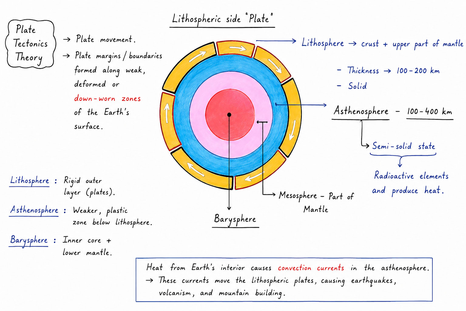
Plate tectonics is the theory which studies plates and various tectonic activities which take place along with plate margin. This theory was given in 1960s by Tuzo Wilson who coined the term Plate, Dan McKenzie, W. Jason Morgan, Arthur Holmes, Harry Hess. According to this theory, earth's outer rigid layer called lithosphere is broken into several large and small slabs which are called plates. These plates float and move slowly over the semi-molten layer beneath them called the asthenosphere. Due to this plate movement, several plate margins are formed along with various tectonic activities like earthquakes, volcanism, mountain building, ocean trenches, and mid-oceanic ridges.
Plate Tectonics
Types of Plates
On the basis of their constituents
Continental Plate
Oceanic Plate
Oceanic cum Continental Plate
On the basis of their size
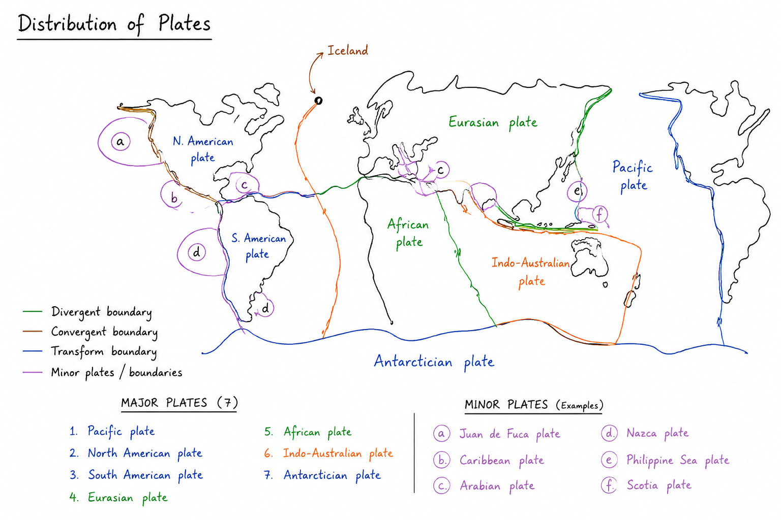
7 Major Plates are
North American Plate
South American Plate
African Plate
European Plate
Indo-Australian Plate
Antarctic Plate
Pacific Plate
20+ Minor Plates
Juan de Fuca
Cocos Plate
Caribbean Plate
Nazca Plate
Scotia Plate
Somalian Plate
Arabian Plate
Turkish Plate
Burma Plate
Philippine Plate
Bismarck Plate
Distribution of Plates
Plate Margin
There are three types of plate margins
Constructive Plate Margin
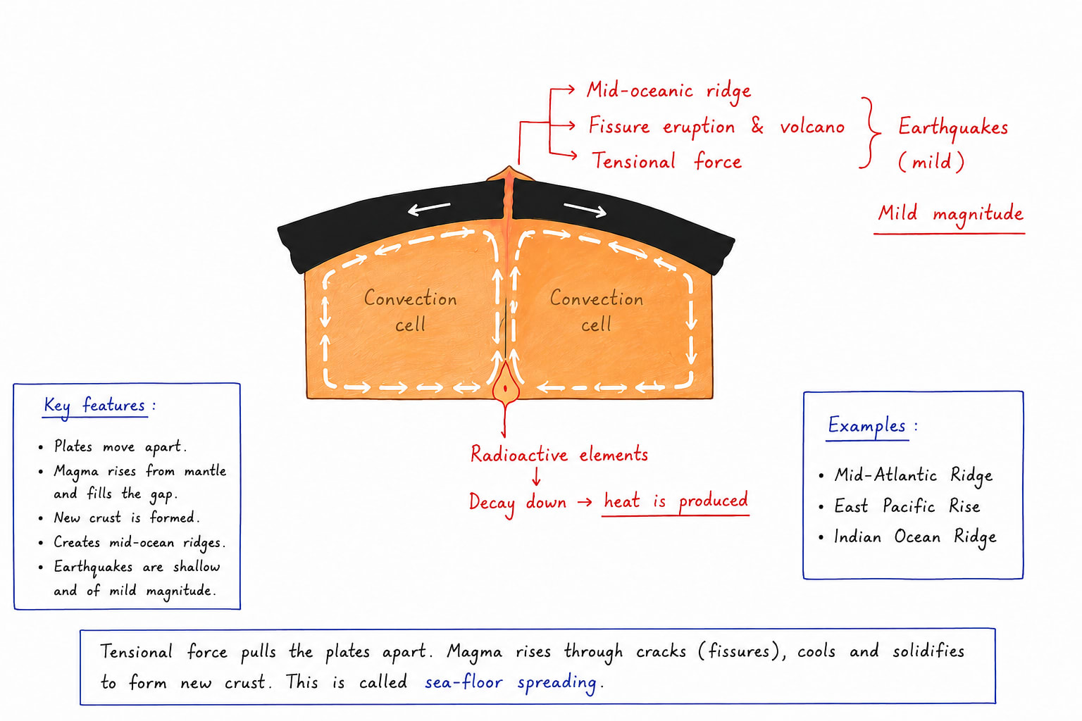
It is formed when two plates move apart due to divergence. Two convection currents operating beneath the lithosphere in the asthenosphere; due to this:
1. Fissure eruption of volcano occurs
2. Mid oceanic ridges are formed e.g. MOR of Atlantic
3. Earthquakes of mild magnitude occur
Conservative Plate Margin
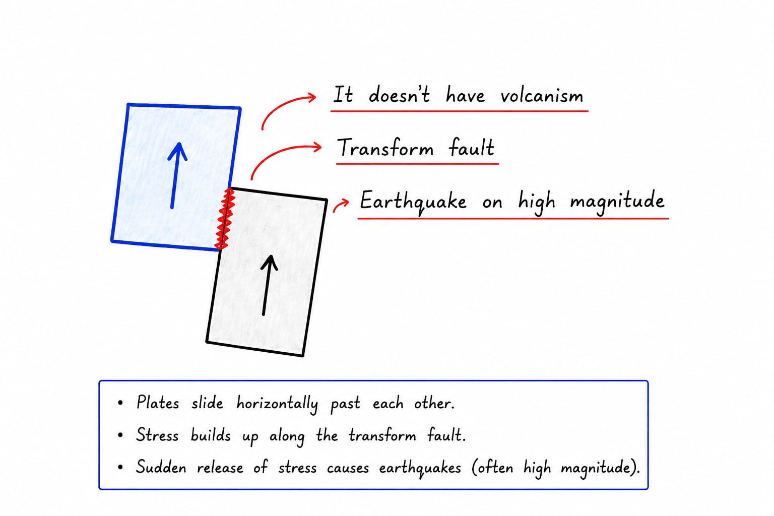
Conservative plate margins are those where two plates neither converge nor diverge. The two plates simply slide past each other, which is why there is no construction or destruction of crust. It only develops:
Transform faults
High Magnitude earthquakes
No volcanism
e.g. San Andreas fault of North America.
Destructive/Convergent Plate Margin
A destructive plate margin or convergent plate boundary develops when two plates move towards each other; in this case, there are three possibilities:
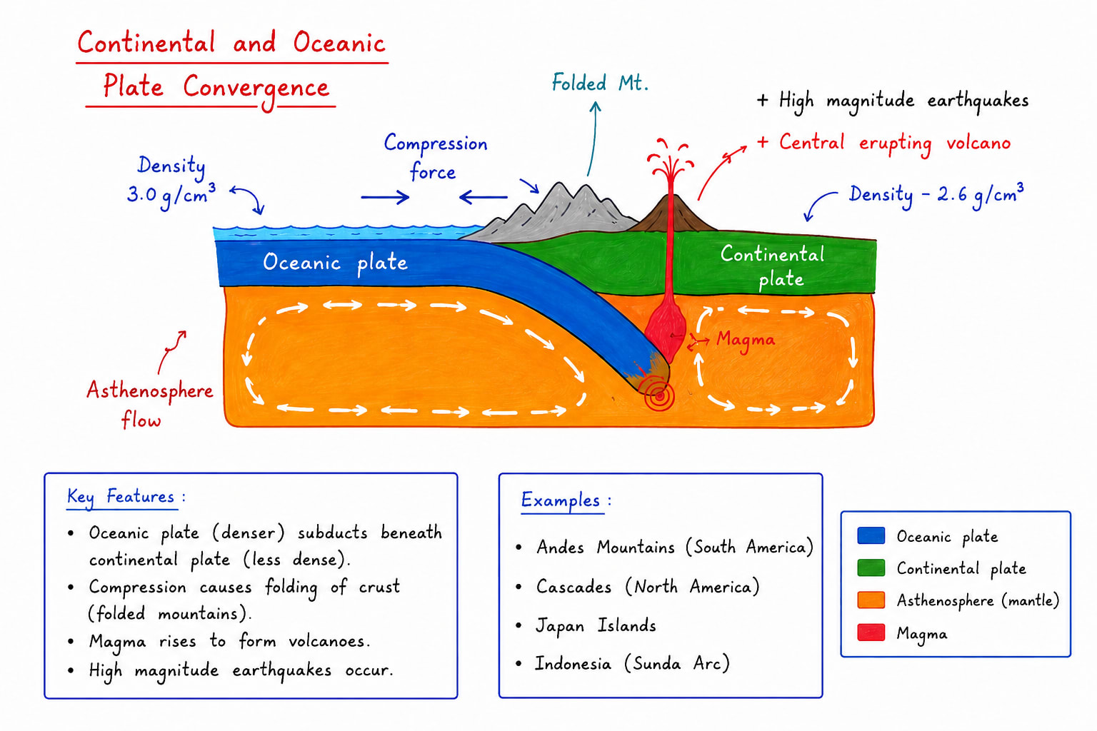
Continental and Oceanic Plate Convergence
In this case
central eruption of volcanoes develop, e.g., Mt. Stromboli of Italy.
folded mountains are formed e.g. the Andes mountains were formed due to plate convergence between the South American plate and the Nazca plate.
high-magnitude earthquakess
Oceanic and Oceanic Plate Convergence
When two oceanic plates converge, the relatively heavier plate subducts under the lighter plate; due to this:
Island arcs are formed and sometimes festoons also.
Central eruption of volcanoes, e.g., Mt. Fuji of Japan, Mt. Mayon and Mount Taal in the Philippines, Mt. Krakatoa of Indonesia.
High Magnitude earthquakes and Tsunami e.g. the 2004 tsunami was near Indonesia, 2011 tsunami was due to Japan
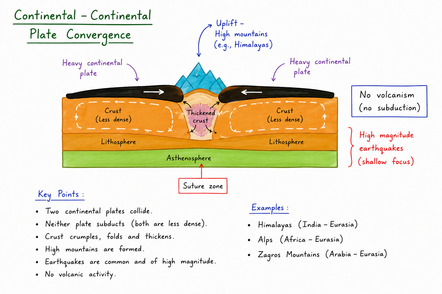
Continental and Continental Plate Convergence
When two continental plates converge, the relatively heavier plate subducts beneath the lighter plate due to this
High mountain ranges are formed, e.g., the Himalayas.
No volcanic eruption because
Thickness of the lithosphere becomes almost double due to subduction / under thrusting
Due to lack of water steam support to rising magma is very weak.
Rising magma is very viscous.
High-magnitude earthquakes.
An island arc is Curved chain of volcanic islands formed at a convergent plate boundary where one oceanic subducts beneath another oceanic plate. The subducted plate melts in the mantle magma rises through cracks. Repeated volcanic eruptions form a chain of islands parallel to the ocean trenches; due to Earth's curvature and plate movement, the chain generally develops a crescent or arc shape. e.g. Japan, Philippines, Indonesia, etc.Festoons are highly curved, chain-like curved arcs that represent the most pronounced form of island arcs, resembling a garland or necklace. They are formed by intense subduction and strong compressional forces. The differential plate movement causes the arc to bend more sharply. These are often associated with deep ocean trenches and active volcanoes. Indonesia and the Philippines are examples of island arcs and festoons.
Indonesia
Indonesia is located where several plates meet such as the Indo-Australian Plate, Eurasian plate, the Pacific Plate and the Philippine Plate.
Formation Process of Indonesia
Stage 1- Subduction of Indo-Australian Plate: The oceanic part of the Indo-Australian plate moves northward. It subducts beneath the Eurasian plateStage 2 - Formation of Ocean Trenches e.g. Java Trench and Sunda TrenchStage 3 - Magma generation: Subduction of the plate in the asthenosphere leads to its melting and formation of magmaStage 4 - Development of Volcanic arc: Magma rose to the surface and formed Volcanic islands like Sumatra, Java, Bali, Lombok, etc.
Indonesia is the world's largest archipelago. It has about 17,000+ islands, over 120 active volcanoes and experiences frequent earthquakes and tsunami due to active subduction.
Formation Process of Philippines
Philippines lies at the junction of Philippine plate, Eurasian plate and Sunda plateStage 1 - Oceanic plate convergence: The The Philippine Sea plate and parts of the Eurasian plate moved toward each other. One heavier oceanic plate began subducting beneath the other.Stage 2 - Formation of deep Trenches: Subduction created deep ocean trenches such as Mariana trench, Mindanao trench.Stage 3 - Magma Generation: The descending plate released water into mantle partial melting occurred. Magma rose through volcanoes.Stage 4 - Volcanic Islands are formed: These islands merge and grew into larger islands such as Luzon.Philippines has more than 7000 island and numerous active volcanoeses.
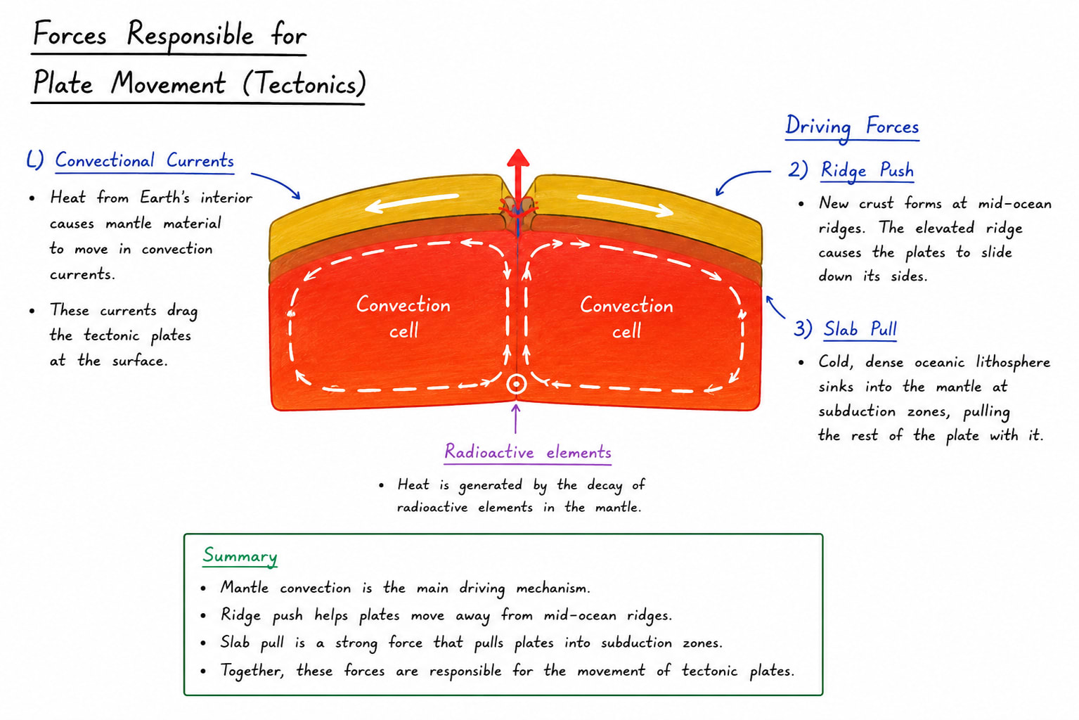
Force responsible for plate Tectonics
According to geoscientists, the most important force responsible for plate movement is the flow of convection currents operating in the asthenosphere. These convection currents are formed due to the decay of radioactive elements, which produces a huge amount of heat and melts the surrounding rock. These molten rocks form convection currents. When two convection cells converge or diverge, the overlying plates converge or diverge, respectively.
There are two secondary forces also responsible for plate movement:
Ridge push force: This force is applied by the magma rising through the divergent plate boundary
Slab Pull: When a subducting plate enters into asthenosphere it pulls rest of the plate inside.
Evidence of Plate Tectonics Theory
Evidence of Plate Tectonics Theory include:
Sea Floor spreading
Palaeomagnetism
Hot spots (Volcanos)
Sea Floor Spreading and its support to Plate Tectonics Theory
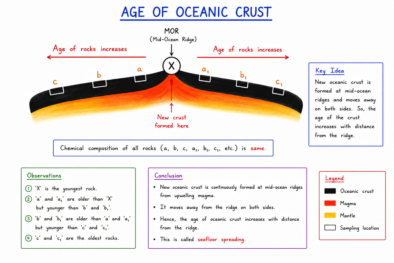
The idea of sea floor spreading refers to the process by which new oceanic crust is formed at mid oceanic ridges and gradually moves away on either side. The concept was proposed by Harry Hess in the 1960s and became a crucial foundation for the theory of plate tectonics.
According to this theory, molten magma rises from the mantle through fissures at divergent plate boundaries, especially along mid oceanic ridges such as mid Atlantic ridge. As the magma cools and solidifies, it forms new basaltic crust. Continuous addition of new material pushes the older crust away from the ridge, causing the ocean floor to spread.
Mechanism of sea floor spreading
Upwelling of magma occurs due to convection currents in the mantle.
New oceanic crust is created at the mid oceanic ridge.
Older crust moves outward symmetrically.
Oceanic crust is eventually destroyed at subduction zones or ocean trenches.
Evidence supporting Sea floor Spreading.
Age of Oceanic Crust:- Rocks near the mid-oceanic ridges are younger while those farther away are older.
It clearly suggests that gradual spreading of the sea floor is a reality.
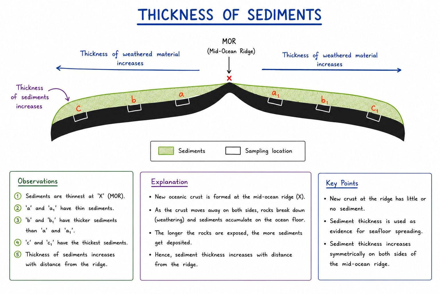
Thickness of Sediments:- Marine sediments are thinner near mid-oceanic ridge and thicker away from them because older crust has had more time to accumulate sediments.
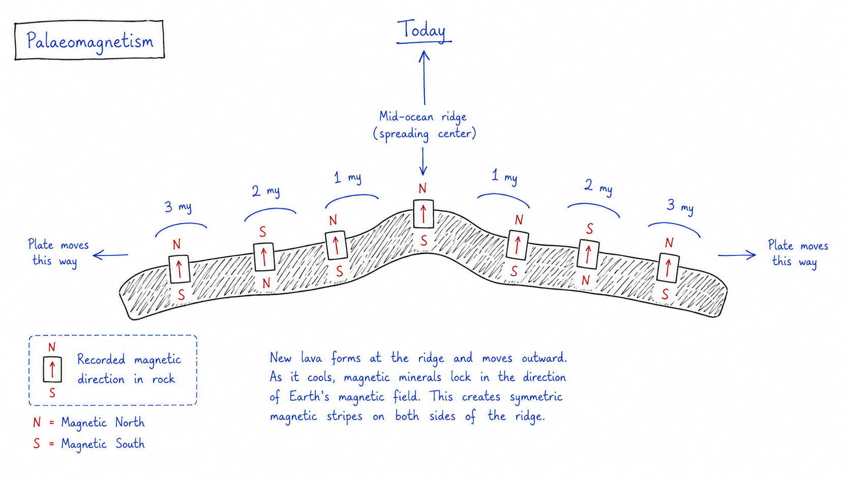
Palaeomagnetism:- Alternating magnetic bands on either side of ocean ridges record periodic reversals in earth's magnetic field. The symmetrical arrangement proves continuous creation and outward movement of oceanic crust.
Sea floor spreading provided the physical mechanism for continental drift proposed by Wegener. It demonstrated that the lithosphere is not stationary but moves continuously over the asthenosphere. The creation of crust at divergent boundaries explains the continental movement, plate movement, mountain building, earthquake, ocean trench formation and volcanism.
Palaeomagnetism
Palaeomagnetism refers to the study of the the record of the Earth's ancient magnetic field preserved in rocks. When volcanic rocks solidify magnetic materials such as magnetite align themselves according to the direction of earth's magnetic field at that time. These magnetic signatures remain locked within the rocks and provide valuable evidence about past movements of continents and ocean floor.
The concept of Palaeomagnetism became a major breakthrough in validating the theory of plate tectonics during the mid 20th Century.
Process of Palaeomagnetism
Earth behaves like a giant magnet with north and south magnetic poles.
Molten rocks containing magnetic minerals align with earth's magnetic fields during cooling.
Once solidified after getting magnetic polarity, the magnetic orientation is preserved permanently. It does not change unless the rock is exposed to higher temperature beyond 600°C (Curie Point).
Over geological time reversals in the Earth's magnetic field create distinct magnetic patterns in rocks.
Evidence from Palaeomagnetism
Magnetic Reversal:- Geological studies revealed alternating bands of normal and reversed polarity on the ocean floor. These magnetic stripes occur symmetrically on both sides of mid-oceanic ridges, providing proof of the continuous formation and outward movement of oceanic crust.
Age and Magnetic Pattern correlation:- The age of rocks increases with distance from mid-oceanic ridges while magnetic patterns remain symmetrical. These confirms sea floor spreading and movement of plates.
Evidence of Continental movement:- Palaeomagnetic data showed that continents such as South America and Africa were once joined and later drifted apart.
Role in supporting Plate Tectonic Theory
Palaeomagnetism provides strong quantitative evidence for both continental drift and sea floor spreading. It demonstrated that lithospheric plates move over time and that oceanic crust is continuously created and displaced.
The discovery of symmetrical magnetic stripes around mid-Atlantic ridge became one of the strongest proofs of plate tectonics. It also explained the dynamic nature of earth's crust including earthquake, volcanism, and mountain building.
Hot spots and their role in supporting plate tectonics
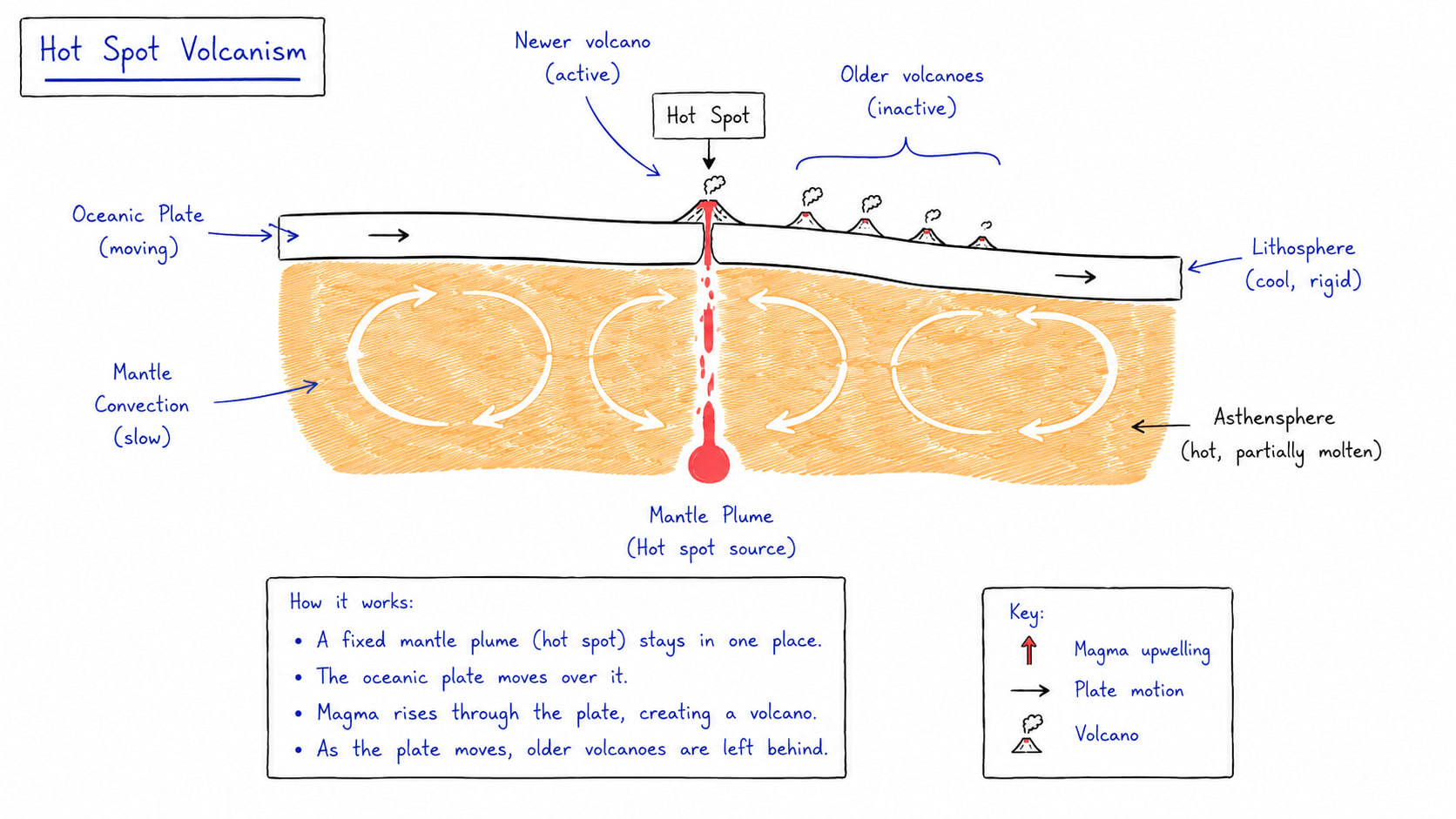
Hot spots are localized zones of intense volcanic activity caused by rising plumes of hot magma from deep within core-mantle boundary and this is called mantle plume.
Unlike ordinary volcanos formed at plate boundaries, hot spots may occur in the interior of a tectonic plate. This concept was explained by Tuzo Wilson and became important evidence for plate tectonics.
A hot spot remains relatively stationary while the tectonic plate moves over it. As the plate shifts, successive volcanoes are formed, creating chains of volcanic islands and seamounts (volcanic mountains formed underwater).
Mechanism for hot spot activity
The mantle plume rises from deep inside earth due to high temperature and low density.
Magma reaches the surface through weak zones in the lithosphere.
Volcanic eruptions create island or volcanic mountains.
As the tectonic plate moves, older volcanoes become inactive and new volcanoes form above the hot spots.
Evidence from hot spots
Volcanic island chains:- Chains of volcanic islands show a clear age progression. The youngest volcano lies above the active hot spot, while older volcanoes are farther away.
Direction and speed of plate movement:- The orientation and age of volcanic chains help scientists determine the direction and rate of tectonic plate movement.
Evidence independent of plate boundary:- Hot spots occur even within the plates proving the plate themselves are moving rather than volcanic zone shifting.
Good example of hot spot are Hawaii hot spot of Pacific, Reunion hot spot of Indian Ocean, Icelandic hot spot of Atlantic ocean, Yellowstone park hot spot of US.
This study guide requires sign-in.
Unlock this full article plus 500+ structured UPSC study notes & instant PDF exports.